
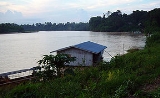
Kelantan River
Encyclopedia
Kelantan
Kelantan is a state of Malaysia. The capital and royal seat is Kota Bharu. The Arabic honorific of the state is Darul Naim, ....
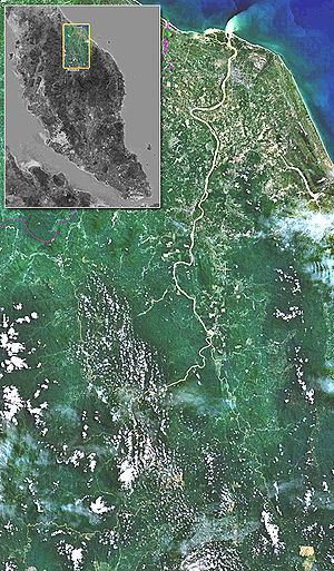
, Malaysia. It drains a catchment area of about 11900 km²
in north-east Malaysia including part of the Taman Negara National Park
Taman Negara National Park
Taman Negara was established in Malaysia in 1938/1939 as the King George V National Park. It was renamed to Taman Negara after independence, which literally means "national park" in Malay...
, and flows northwards into the South China Sea
South China Sea
The South China Sea is a marginal sea that is part of the Pacific Ocean, encompassing an area from the Singapore and Malacca Straits to the Strait of Taiwan of around...
. The rainfall over the area varies between 0 mm in the dry season (March-May) to 1750 mm in the monsoon
Monsoon
Monsoon is traditionally defined as a seasonal reversing wind accompanied by corresponding changes in precipitation, but is now used to describe seasonal changes in atmospheric circulation and precipitation associated with the asymmetric heating of land and sea...
season (November-January). The average runoff
Surface runoff
Surface runoff is the water flow that occurs when soil is infiltrated to full capacity and excess water from rain, meltwater, or other sources flows over the land. This is a major component of the water cycle. Runoff that occurs on surfaces before reaching a channel is also called a nonpoint source...
from the area is about 500 m³/s.
Name and extent
The description of the river is complicated by the local naming convention: instead of using the name Kelantan river from estuary to source, the name is only used for the section from the estuary to the confluence of its two main tributaries, the Galas River and the Lebir River, near the town of Kuala KraiKuala Krai
Kuala Krai is a territory and town in the interior of the State of Kelantan in the north-east of Malaysia.-Kuala Krai territory:...
. The same naming convention applies to these tributaries. Thus to describe the main river from source to mouth involves four names: the River Betis (first 20 miles from the source), then the River Nenggiri, then the River Galas, and finally the Kelantan River.
Route
The river tributaries rise in the forested mountains where many Orang AsliOrang Asli
Orang Asli , is a generic Malaysian term used for people indigenous to Peninsular Malaysia...
tribes live. The area is known for its limestone
Limestone
Limestone is a sedimentary rock composed largely of the minerals calcite and aragonite, which are different crystal forms of calcium carbonate . Many limestones are composed from skeletal fragments of marine organisms such as coral or foraminifera....
outcrops and caves. Along the River Nenggeri section some cave systems show evidence of habitation going back 9000 years, such as Gua Cha near Kuala Betis.
Lower down, Malay villages dot the banks of the river which passes through one of the most densely populated flood plains on the Malay Peninsula
Peninsular Malaysia
Peninsular Malaysia , also known as West Malaysia , is the part of Malaysia which lies on the Malay Peninsula. Its area is . It shares a land border with Thailand in the north. To the south is the island of Singapore. Across the Strait of Malacca to the west lies the island of Sumatra...
whose padi fields
Paddy field
A paddy field is a flooded parcel of arable land used for growing rice and other semiaquatic crops. Paddy fields are a typical feature of rice farming in east, south and southeast Asia. Paddies can be built into steep hillsides as terraces and adjacent to depressed or steeply sloped features such...
produce around 12% of Malaysian rice production.
The river flows past four important towns: Pasir Mas
Pasir Mas
-Geography:The district of Pasir Mas covers an area of 577 square kilometers and is bordered by the districts of Tumpat to the north, Tanah Merah to the south, Kota Bahru to the east, and the Thai district of Su-ngai Kolok to the west...
, Tumpat
Tumpat
Tumpat is a town and a district in Kelantan, Malaysia. Tumpat is situated at the end of the East Coast Line train line operated by Keretapi Tanah Melayu which links Kelantan to the western part of Peninsular Malaysia. This strategic location makes it the transportation hub of Kelantan...
, Kuala Krai
Kuala Krai
Kuala Krai is a territory and town in the interior of the State of Kelantan in the north-east of Malaysia.-Kuala Krai territory:...
and the state capital Kota Bharu
Kota Bharu
Kota Bharu is a city in Malaysia, is the state capital and Royal City of Kelantan. It is also the name of the territory in which Kota Bharu City is situated. The name means 'new city' or 'new castle/fort' in Malay. Kota Bharu is situated in the northeastern part of Peninsular Malaysia, and lies...
, which lies near the mouth of the river. Towards the estuary there are several islands in the river.
The area around the actual estuary, known as Kuala Besar, is dotted with picturesque fishing villages, which are also well-known for the production of batik
Batik
Batik is a cloth that traditionally uses a manual wax-resist dyeing technique. Batik or fabrics with the traditional batik patterns are found in Indonesia, Malaysia, Japan, China, Azerbaijan, India, Sri Lanka, Egypt, Nigeria, Senegal, and Singapore.Javanese traditional batik, especially from...
(a local patterned material produced by waxing and dyeing cloth) for which the State of Kelantan is famous.
Flooding
The Kelantan River regularly overspills its banks during the months of November to February because of the northeast monsoonMonsoon
Monsoon is traditionally defined as a seasonal reversing wind accompanied by corresponding changes in precipitation, but is now used to describe seasonal changes in atmospheric circulation and precipitation associated with the asymmetric heating of land and sea...
season. The estimate flood volume under the 50 year flood condition at Kusial Bridge is about 6 billion m3. Severe flooding occurred in 1926 and 1967. In the 1967 floods 84% of the Kelantan population (537,000 people) were badly affected. Some 125,000 people were evacuated and 38 drowned.
More recently a telemetric flood forecasting
Flood forecasting
Flood forecasting is the use of real-time precipitation and streamflow data in rainfall-runoff and streamflow routing models to forecast flow rates and water levels for periods ranging from a few hours to days ahead, depending on the size of the watershed or river basin. Flood forecasting can also...
system has been installed to give warning of high river levels. Some of the worst floods in recent years have been:
| Year | Evacuees | Deaths | Damage (US$1000) |
|---|---|---|---|
| 2004 | 10476 | 12 | 3767 |
| 2003 | 2228 | 2 | 1461 |
| 2001 | 5800 | 0 | 2227 |
| 1993 | 13587 | 0 | 398 |
| 1988 | 41059 | 0 | ? |
| 1986 | 7963 | 0 | 1603 |
| 1983 | 33815 | 0 | ? |
External links
- Kelantan online river level data - click Sg.Kelantan for current week's river level readings taken every hour - or click the number in the Station id column to plot a graph.
- Taman Negara Taman Negara
- http://dikelantan.com Kelantan