

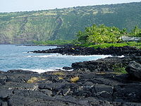
Kealakekua, Hawai'i
Encyclopedia
Kealakekua is a census-designated place
(CDP) in Hawaii County, Hawaii
, United States
. The population was 1,645 at the 2000 census.
It was the subject of the 1933 popular song, "My Little Grass Shack in Kealakekua, Hawaii
" by Bill Cogswell, Tommy Harrison and Johnny Noble
which became a Hawaiian Music standard.
See also: Kealakekua Bay
, where the British explorer Capt. James Cook
was killed.
According to the United States Census Bureau
, the CDP has a total area of 7.5 square miles (19.4 km²), all of it land.
of 2000, there were 1,645 people, 639 households, and 423 families residing in the CDP. The population density
was 218.1 people per square mile (84.2/km²). There were 692 housing units at an average density of 91.7 per square mile (35.4/km²). The racial makeup of the CDP was 24.74% White, 0.73% African American, 0.67% Native American, 36.84% Asian, 7.23% Pacific Islander, 2.07% from other races
, and 27.72% from two or more races. Hispanic or Latino of any race were 9.18% of the population.
 There were 639 households out of which 25.5% had children under the age of 18 living with them, 49.0% were married couples
living together, 12.2% had a female householder with no husband present, and 33.8% were non-families. 26.9% of all households were made up of individuals and 9.2% had someone living alone who was 65 years of age or older. The average household size was 2.57 and the average family size was 3.10.
In the CDP the population was spread out with 22.1% under the age of 18, 7.7% from 18 to 24, 25.3% from 25 to 44, 27.5% from 45 to 64, and 17.3% who were 65 years of age or older. The median age was 42 years. For every 100 females there were 91.5 males. For every 100 females age 18 and over, there were 89.2 males.
The median income for a household in the CDP was $38,026, and the median income for a family was $45,192. Males had a median income of $29,333 versus $25,000 for females. The per capita income
for the CDP was $21,495. About 9.2% of families and 13.7% of the population were below the poverty line, including 17.1% of those under age 18 and 6.3% of those age 65 or over.
are located in the CDP.
Census-designated place
A census-designated place is a concentration of population identified by the United States Census Bureau for statistical purposes. CDPs are delineated for each decennial census as the statistical counterparts of incorporated places such as cities, towns and villages...
(CDP) in Hawaii County, Hawaii
Hawaii County, Hawaii
Hawaii County is a county located in the U.S. state of Hawaii in the Hawaiian Islands. It is coterminous with the Island of Hawaii, often called the "Big Island" to distinguish it from the state as a whole. As of the 2010 Census the population was 185,079. The county seat is Hilo. There are no...
, United States
United States
The United States of America is a federal constitutional republic comprising fifty states and a federal district...
. The population was 1,645 at the 2000 census.
It was the subject of the 1933 popular song, "My Little Grass Shack in Kealakekua, Hawaii
My Little Grass Shack in Kealakekua, Hawaii
My Little Grass Shack in Kealakekua, Hawaii was a popular song written for the July 4th canoe races in Kona in 1933. Tommy Harrison gave the song to Johnny Noble to publish, who revised the music to give it a new melody without changing Bill Cogswell's words. Once published, the song became a major...
" by Bill Cogswell, Tommy Harrison and Johnny Noble
Johnny Noble
-Further reading:...
which became a Hawaiian Music standard.
See also: Kealakekua Bay
Kealakekua Bay
Kealakekua Bay is located on the Kona coast of the island of Hawaii about south of Kailua-Kona.Settled over a thousand years ago, the surrounding area contains many archeological and historical sites such as religious temples, and was listed in the National Register of Historic Places listings on...
, where the British explorer Capt. James Cook
James Cook
Captain James Cook, FRS, RN was a British explorer, navigator and cartographer who ultimately rose to the rank of captain in the Royal Navy...
was killed.
Geography
Kealakekua is located at 19°31′35"N 155°55′22"W (19.526436, -155.922891).According to the United States Census Bureau
United States Census Bureau
The United States Census Bureau is the government agency that is responsible for the United States Census. It also gathers other national demographic and economic data...
, the CDP has a total area of 7.5 square miles (19.4 km²), all of it land.
Demographics
As of the censusCensus
A census is the procedure of systematically acquiring and recording information about the members of a given population. It is a regularly occurring and official count of a particular population. The term is used mostly in connection with national population and housing censuses; other common...
of 2000, there were 1,645 people, 639 households, and 423 families residing in the CDP. The population density
Population density
Population density is a measurement of population per unit area or unit volume. It is frequently applied to living organisms, and particularly to humans...
was 218.1 people per square mile (84.2/km²). There were 692 housing units at an average density of 91.7 per square mile (35.4/km²). The racial makeup of the CDP was 24.74% White, 0.73% African American, 0.67% Native American, 36.84% Asian, 7.23% Pacific Islander, 2.07% from other races
Race (United States Census)
Race and ethnicity in the United States Census, as defined by the Federal Office of Management and Budget and the United States Census Bureau, are self-identification data items in which residents choose the race or races with which they most closely identify, and indicate whether or not they are...
, and 27.72% from two or more races. Hispanic or Latino of any race were 9.18% of the population.
Marriage
Marriage is a social union or legal contract between people that creates kinship. It is an institution in which interpersonal relationships, usually intimate and sexual, are acknowledged in a variety of ways, depending on the culture or subculture in which it is found...
living together, 12.2% had a female householder with no husband present, and 33.8% were non-families. 26.9% of all households were made up of individuals and 9.2% had someone living alone who was 65 years of age or older. The average household size was 2.57 and the average family size was 3.10.
In the CDP the population was spread out with 22.1% under the age of 18, 7.7% from 18 to 24, 25.3% from 25 to 44, 27.5% from 45 to 64, and 17.3% who were 65 years of age or older. The median age was 42 years. For every 100 females there were 91.5 males. For every 100 females age 18 and over, there were 89.2 males.
The median income for a household in the CDP was $38,026, and the median income for a family was $45,192. Males had a median income of $29,333 versus $25,000 for females. The per capita income
Per capita income
Per capita income or income per person is a measure of mean income within an economic aggregate, such as a country or city. It is calculated by taking a measure of all sources of income in the aggregate and dividing it by the total population...
for the CDP was $21,495. About 9.2% of families and 13.7% of the population were below the poverty line, including 17.1% of those under age 18 and 6.3% of those age 65 or over.
Education
Hawaii Department of Education operates public schools. Konawaena Middle School and Konawaena High SchoolKonawaena High School
Konawaena High School is a public school located in the community of Kealakekua, Kona District, Hawaii County, Hawaii, United States. Konawaena means "the center of the leeward side" in the Hawaiian Language.-History:...
are located in the CDP.