
Kay Moor
Encyclopedia
Kay Moor, also known as Kaymoor, is the site of an abandoned coal mine, coal processing plant and company town
near Fayetteville
, West Virginia
. The town site is located in the New River Gorge at Kaymoor Bottom (38°03′00"N 81°03′17"W). It is linked to the mine portal 560 feet (170.7 m) above on Sewell Bench (38°02′52"N 81°03′58"W) in the wall of the Gorge by conveyors. The mine exploited the New River Coalfield
's Sewell Seam of "smokeless" low-volatile bituminous coal
, while the town site was accessible only by the Chesapeake and Ohio Railroad's mainline in the Gorge. The last portion of the Kay Moor complex, Kaymoor Top (38°02′48"N 81°04′09"W) was located at the Gorge rim and served as the terminus for the mountain haulage.
, managing director of the Low Moor Iron Company in Low Moor, Virginia
, which was to be the mine's chief client. The property was kept in reserve until 1899, when the Kay Moor mine was opened to supply coal and coke
to the company's blast furnace
s. In 1925 the mine was sold to the New River and Pocahontas Consolidated Coal Company, a subsidiary of the Berwind-White Corporation of Philadelphia.
The town was named for James Kay, a Low Moor Iron Company employee who was in charge of building the town. Fifty houses were built in 1901, followed by 45 in 1902 and 17 in 1905. A suburb, called New Camp, was built in 1918-1919 with another 19-24 houses, and represents the only extant town site remaining. Kay Moor town's public facilities were spartan, with no churches, saloons, banks or town hall, only pairs of segregated schools at top and bottom, company stores, a pool hall and a ball field. By 1952 Kaymoor Bottom had been abandoned, and in 1960 most of its structures were destroyed by fire.
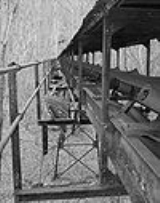
The mine was connected to the town by a single-track incline which lifted workers and equipment up a 1000 feet (304.8 m) slope at a thirty-degree incline. Coal was moved along a similar double-track incline, which lowered coal to the processing plant and the coke ovens, with the cars or monitors moving in opposite directions and partially counterbalancing each other. Both inclines operated until 1962. Initial operations included 120 coking ovens, which were increased to 202 ovens during World War I
. All of the beehive ovens closed in the 1930s, as they had become obsolete.
 The mine itself was a room and pillar
mine that was first worked with mule
-drawn railcars. Locomotives later supplanted the mules.
The entire Kay Moor site is now located within the boundaries of New River Gorge National River
.
Company town
A company town is a town or city in which much or all real estate, buildings , utilities, hospitals, small businesses such as grocery stores and gas stations, and other necessities or luxuries of life within its borders are owned by a single company...
near Fayetteville
Fayetteville, West Virginia
Fayetteville is a town in and the county seat of Fayette County, West Virginia, United States. The population was 2,754 at the 2000 census.Fayetteville was listed as one of the 2006 "Top 10 Coolest Small Towns in America" by Budget Travel Magazine ....
, West Virginia
West Virginia
West Virginia is a state in the Appalachian and Southeastern regions of the United States, bordered by Virginia to the southeast, Kentucky to the southwest, Ohio to the northwest, Pennsylvania to the northeast and Maryland to the east...
. The town site is located in the New River Gorge at Kaymoor Bottom (38°03′00"N 81°03′17"W). It is linked to the mine portal 560 feet (170.7 m) above on Sewell Bench (38°02′52"N 81°03′58"W) in the wall of the Gorge by conveyors. The mine exploited the New River Coalfield
New River Coalfield
The New River Coalfield is located in northeastern Raleigh County and southern Fayette County, West Virginia. Commercial mining of coal began in the 1870s and thrived into the 20th century. The coal in this field is a low volatile coal, and the seams of coal that have been mined include Sewell,...
's Sewell Seam of "smokeless" low-volatile bituminous coal
Bituminous coal
Bituminous coal or black coal is a relatively soft coal containing a tarlike substance called bitumen. It is of higher quality than lignite coal but of poorer quality than Anthracite...
, while the town site was accessible only by the Chesapeake and Ohio Railroad's mainline in the Gorge. The last portion of the Kay Moor complex, Kaymoor Top (38°02′48"N 81°04′09"W) was located at the Gorge rim and served as the terminus for the mountain haulage.
History
The mine property was purchased in 1873 by Abiel Abbot LowAbiel Abbot Low
Abiel Abbot Low was an American entrepreneur, businessman, trader and philanthropist who gained most of his fortune from the China trade, importing teas, porcelains, and silk, and building and operating a fleet of reputable clipper ships.- Early life :Abiel Abbot Low was one of twelve children of...
, managing director of the Low Moor Iron Company in Low Moor, Virginia
Low Moor, Virginia
Low Moor is a census-designated place in Alleghany County, Virginia, in the United States. The population was 367 at the 2000 census.Low Moor was the birthplace of World War II Medal of Honor recipient Jimmie Monteith, for whom Camp Monteith, located in Kosovo, was named.-Geography:Low Moor is...
, which was to be the mine's chief client. The property was kept in reserve until 1899, when the Kay Moor mine was opened to supply coal and coke
Coke (fuel)
Coke is the solid carbonaceous material derived from destructive distillation of low-ash, low-sulfur bituminous coal. Cokes from coal are grey, hard, and porous. While coke can be formed naturally, the commonly used form is man-made.- History :...
to the company's blast furnace
Blast furnace
A blast furnace is a type of metallurgical furnace used for smelting to produce industrial metals, generally iron.In a blast furnace, fuel and ore and flux are continuously supplied through the top of the furnace, while air is blown into the bottom of the chamber, so that the chemical reactions...
s. In 1925 the mine was sold to the New River and Pocahontas Consolidated Coal Company, a subsidiary of the Berwind-White Corporation of Philadelphia.
The town was named for James Kay, a Low Moor Iron Company employee who was in charge of building the town. Fifty houses were built in 1901, followed by 45 in 1902 and 17 in 1905. A suburb, called New Camp, was built in 1918-1919 with another 19-24 houses, and represents the only extant town site remaining. Kay Moor town's public facilities were spartan, with no churches, saloons, banks or town hall, only pairs of segregated schools at top and bottom, company stores, a pool hall and a ball field. By 1952 Kaymoor Bottom had been abandoned, and in 1960 most of its structures were destroyed by fire.
The mine was connected to the town by a single-track incline which lifted workers and equipment up a 1000 feet (304.8 m) slope at a thirty-degree incline. Coal was moved along a similar double-track incline, which lowered coal to the processing plant and the coke ovens, with the cars or monitors moving in opposite directions and partially counterbalancing each other. Both inclines operated until 1962. Initial operations included 120 coking ovens, which were increased to 202 ovens during World War I
World War I
World War I , which was predominantly called the World War or the Great War from its occurrence until 1939, and the First World War or World War I thereafter, was a major war centred in Europe that began on 28 July 1914 and lasted until 11 November 1918...
. All of the beehive ovens closed in the 1930s, as they had become obsolete.
Room and pillar
Room and pillar is a mining system in which the mined material is extracted across a horizontal plane while leaving "pillars" of untouched material to support the roof overburden leaving open areas or "rooms" underground...
mine that was first worked with mule
Mule
A mule is the offspring of a male donkey and a female horse. Horses and donkeys are different species, with different numbers of chromosomes. Of the two F1 hybrids between these two species, a mule is easier to obtain than a hinny...
-drawn railcars. Locomotives later supplanted the mules.
Kay Moor today
The site is now extensively overgrown and obscured by foliage. Structures and machinery have deteriorated due to the corrosive interaction of coal dust and rainwater, while the bench level was salvaged in 1980-81. Despite this, the site retains significant amounts of mining machinery and is considered one of the most complete examples of an integrated coal mine and company town in West Virginia.The entire Kay Moor site is now located within the boundaries of New River Gorge National River
New River Gorge National River
The New River Gorge National River is a unit of the United States National Park Service designed to protect and maintain the New River Gorge in southern West Virginia. Established in 1978, the NPS-protected area stretches for from just downstream of Hinton to Hawks Nest State Park near Ansted.New...
.
Visiting Kay Moor
Kaymoor Top is accessible from Kaymoor No. 1 Road (County Route 9/2). At Kaymoor Top is a trailhead for the Kaymoor Miners Trail, which provides the most direct access to the Kaymoor Mine level (via stairs and switchbacks), and then to Kaymoor Bottom via stairs.. The Kaymoor Mine level is also accessible via the 2 miles (3.2 km) long, relatively flat, Kaymoor Trail; a trailhead is located on County Route 82.See also
- Nuttallburg Coal Mining Complex and Town Historic DistrictNuttallburg Coal Mining Complex and Town Historic DistrictThe Nuttallburg Coal Mining Complex and Town Historic District is located near Fayetteville, West Virginia in New River Gorge National River. The townsite is almost directly across from the Kay Moor mine and townsite, now abandoned...
, a similar town across the New River, listed on the National Register of Historic Places - Thurmond Historic District, a railroad town in the New River Gorge that is still nominally inhabited
External links
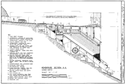
- Kaymoor Coal Mine, South side of New River, upstream of New River Gorge, Fayetteville vicinity, Fayette County, WV: 20 drawings, 76 photos, 34 data pages, 5 photo caption pages, 3 color transparencies, at Historic American Engineering Record
- Kaymoor at New River Gorge National River
- Kaymoor Ruins at coalcampusa.com