
Kaumakani, Hawaii
Encyclopedia
Kaumakani is a census-designated place
(CDP) in Kauai County
, Hawaii
, United States
. The population was 607 at the 2000 census.
) for over forty years; Makaweli was an ancient land division (ahupuaa).
In 1914, the Board on Geographic Names
ruled that the community was to be named Makaweli, and only in 1956 did it name the CDP Kaumakani. Kaumakani has its own post office, with the ZIP code
of 96747.
In 2008, a small settlement to the west at 21°55′59"N 159°38′51"W known as Pakala Village
was designated its own CDP,
and has its own post office with code 96769.
Makaweli Landing at Pākala was called Robinson's Landing, since the family of Aubrey Robinson
ran a private ferry to their island of Niihau
.
Pākala means "the sun shines" in Hawaiian.
at 21°55′13"N 159°37′27"W (21.920292, -159.624281). The main road is Kaumualii Highway, Route 50
.
According to the United States Census Bureau
, the CDP has a total area of 1 square miles (2.6 km²), of which, 0.9 square miles (2.3 km²) of it is land and 0.1 square mile (0.258998811 km²) of it (8.57%) is water.
of 2000, there were 607 people, 207 households, and 162 families residing in the CDP. The population density
was 635.7 people per square mile (246.7/km²). There were 234 housing units at an average density of 245.1 per square mile (95.1/km²). The racial makeup of the CDP was 4% White, 77% Asian, 2% Pacific Islander, <1% from other races
, and 16% from two or more races. Hispanic or Latino of any race were 5% of the population.
There were 207 households out of which 33% had children under the age of 18 living with them, 60% were married couples
living together, 9% had a female householder with no husband present, and 21% were non-families. 18% of all households were made up of individuals and 9% had someone living alone who was 65 years of age or older. The average household size was 2.93 and the average family size was 3.34.
In the CDP the population was spread out with 26% under the age of 18, 6% from 18 to 24, 28% from 25 to 44, 20% from 45 to 64, and 20% who were 65 years of age or older. The median age was 40 years. For every 100 females there were 104.4 males. For every 100 females age 18 and over, there were 102.7 males.
The median income for a household in the CDP was $34,583, and the median income for a family was $41,250. Males had a median income of $26,429 versus $23,654 for females. The per capita income
for the CDP was $14,024. About 9% of families and 11% of the population were below the poverty line, including 11% of those under age 18 and 8% of those age 65 or over.
Census-designated place
A census-designated place is a concentration of population identified by the United States Census Bureau for statistical purposes. CDPs are delineated for each decennial census as the statistical counterparts of incorporated places such as cities, towns and villages...
(CDP) in Kauai County
Kauai County, Hawaii
Kauai County is a county located in the U.S. state of Hawaii. It consists of the islands of Kauai, Niihau, Lehua, and Kaula, in the state of Hawaii. As of 2000 Census the population was 58,463...
, Hawaii
Hawaii
Hawaii is the newest of the 50 U.S. states , and is the only U.S. state made up entirely of islands. It is the northernmost island group in Polynesia, occupying most of an archipelago in the central Pacific Ocean, southwest of the continental United States, southeast of Japan, and northeast of...
, United States
United States
The United States of America is a federal constitutional republic comprising fifty states and a federal district...
. The population was 607 at the 2000 census.
History
Kaumakani was officially known as Makaweli (which means "fearful features" in the Hawaiian LanguageHawaiian language
The Hawaiian language is a Polynesian language that takes its name from Hawaii, the largest island in the tropical North Pacific archipelago where it developed. Hawaiian, along with English, is an official language of the state of Hawaii...
) for over forty years; Makaweli was an ancient land division (ahupuaa).
In 1914, the Board on Geographic Names
United States Board on Geographic Names
The United States Board on Geographic Names is a United States federal body whose purpose is to establish and maintain uniform usage of geographic names throughout the U.S. government.-Overview:...
ruled that the community was to be named Makaweli, and only in 1956 did it name the CDP Kaumakani. Kaumakani has its own post office, with the ZIP code
ZIP Code
ZIP codes are a system of postal codes used by the United States Postal Service since 1963. The term ZIP, an acronym for Zone Improvement Plan, is properly written in capital letters and was chosen to suggest that the mail travels more efficiently, and therefore more quickly, when senders use the...
of 96747.
In 2008, a small settlement to the west at 21°55′59"N 159°38′51"W known as Pakala Village
Pakala Village, Hawaii
Pākalā Village is a census-designated place in Kauai County, Hawaii, United States. The population was 478 at the 2000 census.-History:...
was designated its own CDP,
and has its own post office with code 96769.
Makaweli Landing at Pākala was called Robinson's Landing, since the family of Aubrey Robinson
Aubrey Robinson (Hawaii)
Aubrey Robinson was an owner of a sugarcane plantation and a ranch consisting of an entire island in the Hawaiian Islands.-Life:...
ran a private ferry to their island of Niihau
Niihau
Niihau or Niihau is the seventh largest of the inhabited Hawaiian Islands in the U.S. state of Hawaii, having an area of . Niihau lies southwest of Kauai across the Kaulakahi Channel. Several intermittent playa lakes provide wetland habitats for the Hawaiian Coot, the Black-winged Stilt, and the...
.
Pākala means "the sun shines" in Hawaiian.
Geography
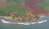
Kaumakani is located on the southern shore of Kauai islandKauai
Kauai or Kauai, known as Tauai in the ancient Kaua'i dialect, is geologically the oldest of the main Hawaiian Islands. With an area of , it is the fourth largest of the main islands in the Hawaiian archipelago, and the 21st largest island in the United States. Known also as the "Garden Isle",...
at 21°55′13"N 159°37′27"W (21.920292, -159.624281). The main road is Kaumualii Highway, Route 50
Hawaii Route 50
Route 50 is a road that stretches from Route 56 at the junction of Rice Street in Lihue to a point approximately 1/5 mile north of the northernmost entrance of the Pacific Missile Range Facility on the western shore of Kauai. It is the longest numbered road on the island of Kauai is named...
.
According to the United States Census Bureau
United States Census Bureau
The United States Census Bureau is the government agency that is responsible for the United States Census. It also gathers other national demographic and economic data...
, the CDP has a total area of 1 square miles (2.6 km²), of which, 0.9 square miles (2.3 km²) of it is land and 0.1 square mile (0.258998811 km²) of it (8.57%) is water.
Demographics
As of the censusCensus
A census is the procedure of systematically acquiring and recording information about the members of a given population. It is a regularly occurring and official count of a particular population. The term is used mostly in connection with national population and housing censuses; other common...
of 2000, there were 607 people, 207 households, and 162 families residing in the CDP. The population density
Population density
Population density is a measurement of population per unit area or unit volume. It is frequently applied to living organisms, and particularly to humans...
was 635.7 people per square mile (246.7/km²). There were 234 housing units at an average density of 245.1 per square mile (95.1/km²). The racial makeup of the CDP was 4% White, 77% Asian, 2% Pacific Islander, <1% from other races
Race (United States Census)
Race and ethnicity in the United States Census, as defined by the Federal Office of Management and Budget and the United States Census Bureau, are self-identification data items in which residents choose the race or races with which they most closely identify, and indicate whether or not they are...
, and 16% from two or more races. Hispanic or Latino of any race were 5% of the population.
There were 207 households out of which 33% had children under the age of 18 living with them, 60% were married couples
Marriage
Marriage is a social union or legal contract between people that creates kinship. It is an institution in which interpersonal relationships, usually intimate and sexual, are acknowledged in a variety of ways, depending on the culture or subculture in which it is found...
living together, 9% had a female householder with no husband present, and 21% were non-families. 18% of all households were made up of individuals and 9% had someone living alone who was 65 years of age or older. The average household size was 2.93 and the average family size was 3.34.
In the CDP the population was spread out with 26% under the age of 18, 6% from 18 to 24, 28% from 25 to 44, 20% from 45 to 64, and 20% who were 65 years of age or older. The median age was 40 years. For every 100 females there were 104.4 males. For every 100 females age 18 and over, there were 102.7 males.
The median income for a household in the CDP was $34,583, and the median income for a family was $41,250. Males had a median income of $26,429 versus $23,654 for females. The per capita income
Per capita income
Per capita income or income per person is a measure of mean income within an economic aggregate, such as a country or city. It is calculated by taking a measure of all sources of income in the aggregate and dividing it by the total population...
for the CDP was $14,024. About 9% of families and 11% of the population were below the poverty line, including 11% of those under age 18 and 8% of those age 65 or over.