
Kasur District
Encyclopedia
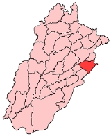
Kasur District or Qasur District is one of the districts in the province of Punjab
, Pakistan
It came into existence on 1 July 1976. Earlier it was part of Lahore District
.
The district capital is Kasur
city, the birth city of the Sufi poet Bulleh Shah
, well known in that region as well as in the whole of Pakistan
. The total area of the district is 3,995 square kilometres.
Before the 1947 Partition The countryside of Kasur was predominantly Sikh, though the town of Kasur itself had a large Muslim majority.
:
in the north-west and river Sutlej
in the south-east. Whereas the old course of Beas River
bifurcates the district into two equal parts locally known as Hither and Uthar or Mithan Majh. Both of the areas have a height differential of approximately 5.5 meters. The natural surface elevation of the district is 198 meters above the sea level, having a general slope from north-east to south- west. Whereas the east and west ends of the district comprise the flood plains of the rivers Satluj and Ravi
, characterized by breaching of looping river Channels braided around meander bars.
which flows its boundary with Sheikhupura District
. The districts may be divided into two parts, a low lying or riverine area along the two bordering rivers and upland, away from the rivers. The riverine area is generally inundates during monsoon
season. The water level in this area is higher than in the upland. The soil is sandy. The upland is flat plains sloping from north-west to south-west. The general height of the area is from 150 to 200 meters above the sea level.
of the district has been greatly modified by human agency of the old open forests of small trees and shrubs; there remains only a few Rakhs or portions of forest which are kept as gazing ground for cattle etc. Amongst trees the most important are Kikar (Acacia arbica), Shisham or Tahli (Dalbergia sissoo), Beri (Zizyphus jajaba), Toot (Morus marlaccae), Sharin (Albizzia lebbek, Dharek (Malia azerdaracb), Phulahi (Acacia modesta), and Nim (Melia indica), Piple (Ficus indica) are planted for shade.The growth in Rakhs is composed mainly of three kinds of trees Jand (Prosopis spicigera), Karril (Capparis aphylla), and van or Jal (Salvadora obeoides). Occasionally pelu (acacia Loucophhloea) and Farash (Tamarix articulate) are also found. Pilchi (Tamarix gallio) is found on moist sandy soil along the rivers and is used for wicker-work, basket making etc.
Tehsil but jackal are found every where. Changa Manga
reserve a thick forest is the only area in which a few Nelgai, pig, peafowl and here are found.
Punjab (Pakistan)
Punjab is the most populous province of Pakistan, with approximately 45% of the country's total population. Forming most of the Punjab region, the province is bordered by Kashmir to the north-east, the Indian states of Punjab and Rajasthan to the east, the Pakistani province of Sindh to the...
, Pakistan
Pakistan
Pakistan , officially the Islamic Republic of Pakistan is a sovereign state in South Asia. It has a coastline along the Arabian Sea and the Gulf of Oman in the south and is bordered by Afghanistan and Iran in the west, India in the east and China in the far northeast. In the north, Tajikistan...
It came into existence on 1 July 1976. Earlier it was part of Lahore District
Lahore District
Lahore District is a district in the Punjab province of Pakistan that contains the city of Lahore, the district and provincial capital. The total area is...
.
The district capital is Kasur
Kasur
Kasur , the capital of Kasur District in Pakistan. Kasur is located adjacent to the border of Ganda Singh Wala between Pakistan and India, and is a tourist attraction because of the daily occurring Flags lowering ceremony...
city, the birth city of the Sufi poet Bulleh Shah
Bulleh Shah
Bulleh Shah was a Punjabi Sufi poet, a humanist and philosopher.-Early life:Bulleh Shah is believed to have been born in 1680, in the small village of Uch, Bahawalpur, Punjab, in present day Pakistan. His father, Shah Muhammad Darwaish, was a teacher and preacher in a village mosque...
, well known in that region as well as in the whole of Pakistan
Pakistan
Pakistan , officially the Islamic Republic of Pakistan is a sovereign state in South Asia. It has a coastline along the Arabian Sea and the Gulf of Oman in the south and is bordered by Afghanistan and Iran in the west, India in the east and China in the far northeast. In the north, Tajikistan...
. The total area of the district is 3,995 square kilometres.
Population
According to the 1998 census, the total population of the district is 2,376,000. Of this 95.4% are Muslims, 4.4% are Christians while the rest are Ahmadis, Hindus and scheduled castes. 22.78% of them lived in the urban areas.Before the 1947 Partition The countryside of Kasur was predominantly Sikh, though the town of Kasur itself had a large Muslim majority.
Administration
The district is administratively subdivided into 4 tehsils and 141 Union CouncilsUnion Councils of Pakistan
A sherwan or village council in Pakistan is an elected local government body consisting of 21 councillors, and headed by a nazim and a naib nazim...
:
| Name of Tehsil | Number of Unions | ||
|---|---|---|---|
| Chunian Chunian Chunian is an historic city of Punjab, Pakistan. It is located at 30° 58' 0N 73° 58' 60E. The is located at an elevations of 177 metres , and lies about 70 km south of Lahore, the Punjab capital. It is the headquarters of a tehsil or revenue sub-division of the same name in Kasur District... |
27 | ||
| Kasur Kasur Kasur , the capital of Kasur District in Pakistan. Kasur is located adjacent to the border of Ganda Singh Wala between Pakistan and India, and is a tourist attraction because of the daily occurring Flags lowering ceremony... |
55 | ||
| Pattoki Pattoki Pattoki is a town in the Kasur District of the Punjab province of Pakistan. It is the headquarters of Pattoki Tehsil, an administrative subdivision of the district, and is located at 31°1'0N 73°50'60E with an altitude of 186 metres .... |
31 | ||
| Kot Radha Kishen | 28 | Total | 141 |
Physical features
The district is bounded by the Ravi RiverRavi River
The Ravi is a trans-boundary river flowing through Northwestern India and eastern Pakistan. It is one of the six rivers of the Indus System in Punjab region ....
in the north-west and river Sutlej
Sutlej
The Sutlej River is the longest of the five rivers that flow through the historic crossroad region of Punjab in northern India and Pakistan. It is located north of the Vindhya Range, south of the Hindu Kush segment of the Himalayas, and east of the Central Sulaiman Range in Pakistan.The Sutlej...
in the south-east. Whereas the old course of Beas River
Beas River
The Beas River is a river in the northern part of India. The river rises in the Himalayas in central Himachal Pradesh, India, and flows for some 470 km to the Sutlej River in the Indian state of Punjab....
bifurcates the district into two equal parts locally known as Hither and Uthar or Mithan Majh. Both of the areas have a height differential of approximately 5.5 meters. The natural surface elevation of the district is 198 meters above the sea level, having a general slope from north-east to south- west. Whereas the east and west ends of the district comprise the flood plains of the rivers Satluj and Ravi
Ravi River
The Ravi is a trans-boundary river flowing through Northwestern India and eastern Pakistan. It is one of the six rivers of the Indus System in Punjab region ....
, characterized by breaching of looping river Channels braided around meander bars.
Topography
Topographically speaking, Kasur District lies between the river Satluj which flows along its boundaries with India and river RaviRavi River
The Ravi is a trans-boundary river flowing through Northwestern India and eastern Pakistan. It is one of the six rivers of the Indus System in Punjab region ....
which flows its boundary with Sheikhupura District
Sheikhupura District
Sheikhupura District is a district of Punjab province, Pakistan. Sheikhupura is the headquarters of Sheikhupura District. According to the 1998 census of Pakistan, the district had a population of 3,321,029 of which 25.45% were urban....
. The districts may be divided into two parts, a low lying or riverine area along the two bordering rivers and upland, away from the rivers. The riverine area is generally inundates during monsoon
Monsoon
Monsoon is traditionally defined as a seasonal reversing wind accompanied by corresponding changes in precipitation, but is now used to describe seasonal changes in atmospheric circulation and precipitation associated with the asymmetric heating of land and sea...
season. The water level in this area is higher than in the upland. The soil is sandy. The upland is flat plains sloping from north-west to south-west. The general height of the area is from 150 to 200 meters above the sea level.
Flora
FloraFlora
Flora is the plant life occurring in a particular region or time, generally the naturally occurring or indigenous—native plant life. The corresponding term for animals is fauna.-Etymology:...
of the district has been greatly modified by human agency of the old open forests of small trees and shrubs; there remains only a few Rakhs or portions of forest which are kept as gazing ground for cattle etc. Amongst trees the most important are Kikar (Acacia arbica), Shisham or Tahli (Dalbergia sissoo), Beri (Zizyphus jajaba), Toot (Morus marlaccae), Sharin (Albizzia lebbek, Dharek (Malia azerdaracb), Phulahi (Acacia modesta), and Nim (Melia indica), Piple (Ficus indica) are planted for shade.The growth in Rakhs is composed mainly of three kinds of trees Jand (Prosopis spicigera), Karril (Capparis aphylla), and van or Jal (Salvadora obeoides). Occasionally pelu (acacia Loucophhloea) and Farash (Tamarix articulate) are also found. Pilchi (Tamarix gallio) is found on moist sandy soil along the rivers and is used for wicker-work, basket making etc.
Fauna
Wolf and jackal are the only wild animals of any importance. The former being met with occasionally in the low land wastes of ChunianChunian
Chunian is an historic city of Punjab, Pakistan. It is located at 30° 58' 0N 73° 58' 60E. The is located at an elevations of 177 metres , and lies about 70 km south of Lahore, the Punjab capital. It is the headquarters of a tehsil or revenue sub-division of the same name in Kasur District...
Tehsil but jackal are found every where. Changa Manga
Changa Manga
The Changa Manga is a planted forest and a wildlife park in Lahore District, Punjab, Pakistan.-Forestry:The forest is entered from a road from off the N-5 Highway near Bhai Pheru. The forest covers an area of and is one of the largest man-made forests on the planet...
reserve a thick forest is the only area in which a few Nelgai, pig, peafowl and here are found.
Places of interest
- Shrine of Baba Bulleh ShahBulleh ShahBulleh Shah was a Punjabi Sufi poet, a humanist and philosopher.-Early life:Bulleh Shah is believed to have been born in 1680, in the small village of Uch, Bahawalpur, Punjab, in present day Pakistan. His father, Shah Muhammad Darwaish, was a teacher and preacher in a village mosque...
, KasurKasurKasur , the capital of Kasur District in Pakistan. Kasur is located adjacent to the border of Ganda Singh Wala between Pakistan and India, and is a tourist attraction because of the daily occurring Flags lowering ceremony...
City - Ganda Singh WalaGanda Singh Walathumb|alt=Full-length It is the snapshot of Ganda sing border kasur where the flag lowering ceremony is underway in feb 2010|Ganda Singh Wala Border, Flag Lowering CeremonyAbout=...
Border, Pakistan-India Border. - Balloki Headworks
- Changa Manga Forest, near ChunianChunianChunian is an historic city of Punjab, Pakistan. It is located at 30° 58' 0N 73° 58' 60E. The is located at an elevations of 177 metres , and lies about 70 km south of Lahore, the Punjab capital. It is the headquarters of a tehsil or revenue sub-division of the same name in Kasur District...
Town - Shrine of Hazrat Abdullah Shah Bukhari(Baba Sha Jhanda), near Pattoki city
External links
Additional references
- District Census Report of Kasur, Population Census Organisation, Statistics Division, Government of Pakistan, Islamabad, August 2000.