
Kangsabati River
Encyclopedia
- For river in AfricaAfricaAfrica is the world's second largest and second most populous continent, after Asia. At about 30.2 million km² including adjacent islands, it covers 6% of the Earth's total surface area and 20.4% of the total land area...
see Kasai RiverKasai RiverThe Kasai River is a tributary of the Congo River, located in central Africa. The river begins in Angola and serves as the border between Angola and the Democratic Republic of the Congo , then flows into the DRC, where it joins the Congo northeast of Kinshasa. The Kasai's tributaries include the...
Kangsabati River (also variously known as the Kasai and Cossye) rises from the Chota Nagpur
Chota Nagpur
Chota Nagpur may refer to*Chota Nagpur Plateau*Chhotanagpur*Chota Nagpur Division, a division of British India *Chota Nagpur States, a collection of princely states of British India...
plateau
Plateau
In geology and earth science, a plateau , also called a high plain or tableland, is an area of highland, usually consisting of relatively flat terrain. A highly eroded plateau is called a dissected plateau...
in the state of Jharkhand
Jharkhand
Jharkhand is a state in eastern India. It was carved out of the southern part of Bihar on 15 November 2000. Jharkhand shares its border with the states of Bihar to the north, Uttar Pradesh and Chhattisgarh to the west, Orissa to the south, and West Bengal to the east...
, India
India
India , officially the Republic of India , is a country in South Asia. It is the seventh-largest country by geographical area, the second-most populous country with over 1.2 billion people, and the most populous democracy in the world...
and passes through the districts of Purulia
Purulia
Purulia , also spelled Puruliya, also known as "Manbhum City", is a city located in West Bengal state, India, and was constituted in 1876. It is the location of the district headquarters of Purulia district. Purulia is located on the north of the Kasai river and is a major road and railway...
, Bankura
Bankura
Bankura is a city and a municipality in Bankura District in the state of West Bengal, India. It is the headquarters of the Bankura District.-Etymology:...
and Paschim Medinipur
Paschim Medinipur
Paschim Medinipur district or West Midnapore district is the districts of the state of West Bengal, India. It was formed on January 1, 2002 after the Partition of Midnapore into Paschim Medinipur and Purba Medinipur. The district has 4 sub-divisions: Kharagpur, Medinipur Sadar, Ghatal and Jhargram...
in West Bengal
West Bengal
West Bengal is a state in the eastern region of India and is the nation's fourth-most populous. It is also the seventh-most populous sub-national entity in the world, with over 91 million inhabitants. A major agricultural producer, West Bengal is the sixth-largest contributor to India's GDP...
before draining in the Hooghly River.
Course
After rising near JhaldaJhalda
'Jhalda is a city and a municipality in Purulia District in the Indian state of West Bengal. GeographyJhalda is located at . It has an average elevation of ....
in the Chota Nagpur plateau in Purulia district
Purulia District
Purulia district is one of the nineteen districts of West Bengal state in eastern India. The town of Purulia is the administrative headquarters of the district.-History:...
, it passes by Khatra
Khatra
Khatra is headquarters of a sub-division of Bankura District, in the state of West Bengal, India.-Geography:Khatra is in the south-west of Bankura District, which is itself to the west of the southern part of West Bengal...
and Ranibandh in Bankura district
Bankura District
Bankura district is one of the seven districts of Burdwan Division in the Indian state of West Bengal. The district has been described as the “connecting link between the plains of Bengal on the east and Chota Nagpur plateau on the west.” The areas to the east and north-east are low lying alluvial...
, and then enters Paschim Medinipur in the Binpur area. It is joined by Bhairabbanki. At Keshpur the river splits into two. The northern branch flows through the Daspur area as Palarpai and joins the Rupnarayan River
Rupnarayan River
The Rupnarayan River is a river in India. It begins as the Dhaleswari in the Chhota Nagpur plateau foothills northeast of the town of Purulia. It then follows a tortuous southeasterly course past the town of Bankura, where it is known as the Dwarakeswar river. Near the town of Ghatal it is...
. The other branch f;ows in a south-easterly direction and on joining the Kaliaghai River forms the Haldi River, which flows in to the Hooghly River at Haldia
Haldia
Haldia has a typical moderate climate with winter temperatures ranging from a low of around 7 degrees Celsius to a high of 22 degrees Celsius. Winters are chilly and is when the residents hold the Haldia Utsav festival. Summers can be very hot and humid. Usual summer temperatures in May, the...
.
Mukutmanipur
Mukutmanipur
Mukutmanipur is a town in Bankura district of West Bengal, India. It is located at the confluence of the Kangsabati and Kumari rivers close to the Jharkhand border.- Kangsabati project :...
, Midnapore
Midnapore
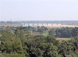
Midnapore is the district headquarters of Paschim Medinipur district of West Bengal. It is situated on the banks of the Kangsabati River . This area had taken a pioneering role in India's freedom struggle...
, and Kharagpur
Kharagpur
Kharagpur is an industrial city in India. It is located in the Midnapore West district of the state of West Bengal.Kharagpur was chosen as the location of the first campus of the prestigious Indian Institutes of Technology . The IITs are the premier technical education institutes in India and...
are towns on or near the banks of this river.
Kangsabati Project
The Kangsabati ProjectKangsabati Project
The Kangsabati Project , also often referred to as the Kangsabati Irrigation Project and The Kangsabati Reservoir Project, is a project started in the Indian state of West Bengal in 1956 as part of the Indian Second Five-year Plan to provide water to 3,484.77 km² of land in the districts of Paschim...
was started in 1956 as part of the Indian Second Five-year Plan to provide water to 3,484.77 km² of land in the districts of Paschim Medinipur, Purba Medinipur
Purba Medinipur
Purba Medinipur district , or East Midnapore district is an administrative unit in the Indian state of West Bengal. It is the southernmost district of Burdwan division – one of the three administrative divisions of West Bengal. The headquarter is located at Tamluk...
, Bankura
Bankura District
Bankura district is one of the seven districts of Burdwan Division in the Indian state of West Bengal. The district has been described as the “connecting link between the plains of Bengal on the east and Chota Nagpur plateau on the west.” The areas to the east and north-east are low lying alluvial...
, and Hooghly
Hooghly District
Hooghly district is one of the districts of the state of West Bengal in India. It can alternatively be spelt Hoogli or Hugli. The district is named after the Hooghly River.The headquarters of the district are at Chinsura...
. It involves irrigation land using water from the Kangsabati River, as well as the Shilabati
Shilabati River
The Shilabati River originates in the terrain of the Chhota Nagpur Plateau in the Purulia district of the state of West Bengal in eastern India. It flows in an almost southeasterly direction through the districts of Bankura and West Midnapore. The Shilabati joins the Dwarakeswar near Ghatal and...
and the Bhoirobbanki rivers.
As part of the Project, a 38 m high and 10,098 m long dam
Dam
A dam is a barrier that impounds water or underground streams. Dams generally serve the primary purpose of retaining water, while other structures such as floodgates or levees are used to manage or prevent water flow into specific land regions. Hydropower and pumped-storage hydroelectricity are...
was constructed at Khatra
Khatra
Khatra is headquarters of a sub-division of Bankura District, in the state of West Bengal, India.-Geography:Khatra is in the south-west of Bankura District, which is itself to the west of the southern part of West Bengal...
. A anicut dam built on the Kangsabati River near Midnapore
Midnapore
Midnapore is the district headquarters of Paschim Medinipur district of West Bengal. It is situated on the banks of the Kangsabati River . This area had taken a pioneering role in India's freedom struggle...
in 1872 was also added to the operations of the project.