
Kangaroo Valley, New South Wales
Encyclopedia
Kangaroo Valley is a valley along the Kangaroo River in the Illawarra
region of New South Wales, Australia, located west of the seaside in the City of Shoalhaven
. It is also the name of the small township within it, formerly known as Osborne, with a population of 319 in the 2006 census
.
Kangaroo Valley has a bus service to Nowra and Moss Vale. Priors Scenic Express also provides a long distance coach service to Bowral, Mittagong, and Greater Sydney as well as to the Shoalhaven and South Coast (as far as Narooma).
 The first inhabitants of Kangaroo Valley were the Wodi-Wodi Aboriginals, who had reportedly occupied the land for around 20,000 years before the European settlement of Australia in 1788. An 1826 census indicated 79 Aborigines lived in the valley in five separate encampments.
The first recorded European sighting of the valley was in April 1812, when surveyor-explorer George Evans
passed through the area as he travelled north from his exploration of Jervis Bay
. Evans reportedly claimed that the valley offered a view that "no painter could beautify."
The area was first settled in 1817 when Charles Throsby
, an explorer and Captain Richard Brooks
, a cattleman, opened the area for white settlement. The felling and exporting of cedar trees quickly became the valley's main industry. By the mid 1840s, the valley also became home to a number of dairy farmers, who specialized in the production of butter as other dairy products such as milk couldn't be exported as they would often curdle long before they had completed the treacherous journey out of the valley to neighboring settlements.
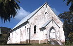
By the 1870s activity had begun to focus in the area that is now the village, as other centers in the valley, such as Trendally, died with the valley's dairy industry. Both the Church of the Good Shepherd (built in 1870–72) and rectory (built in 1879 by John Tanner) were designed by John Horbury Hunt
, and are listed on the Register of the National Estate
.
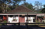
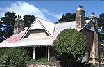
The local public school was built in 1884 of local stone. Further additions constructed of weatherboard and brick were made later. The local court house was built circa 1910, also of local stone. The design is asymmetrical and features a sloping buttress and arch. The main buildings include a residence and lock-up as well as the court house itself. Alterations and extensions have taken place over the years. The local school and the court house are both listed on the Register of the National Estate.
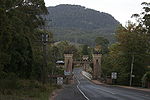
The valley has changed very little in the past 130 years with reminders such as the historical Hampden Bridge
(the oldest suspension bridge in Australia, completed in May 1898) and old Barrengarry School serving as a testimony to the past when the valley was home to a flourishing dairy industry. Agriculture still exists in the valley today though other industries such as tourism and outdoor recreation have since taken over as the valley's primary source of income.
, approximately two hours drive south-west of Sydney and about two hours north of Canberra. Flying Fox Pass
looks over the valley.
has an outdoor education campus for year nine students in the valley, with the name of Glengarry. The Glengarry campus itself consists of four 20-boy dorms, six classrooms, a gymnasium and a theaterette. Glengarry itself spans over 200 acre (0.809372 km²).
Illawarra
Illawarra is a region in the Australian state of New South Wales. It is a coastal region situated immediately south of Sydney and north of the Shoalhaven or South Coast region. It encompasses the cities of Wollongong, Shellharbour, Shoalhaven and the town of Kiama. The central region contains Lake...
region of New South Wales, Australia, located west of the seaside in the City of Shoalhaven
Shoalhaven
The City of Shoalhaven is a Local Government Area in south-eastern New South Wales , Australia, two hours south of Sydney. It is more or less conterminous with an area referred to as The Shoalhaven. It is on the Pacific Ocean and the Princes Highway and is the terminus of the South Coast line...
. It is also the name of the small township within it, formerly known as Osborne, with a population of 319 in the 2006 census
Census in Australia
The Australian census is administered once every five years by the Australian Bureau of Statistics. The most recent census was conducted on 9 August 2011; the next will be conducted in 2016. Prior to the introduction of regular censuses in 1961, they had also been run in 1901, 1911, 1921, 1933,...
.
General
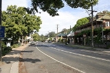
The small town has several arts and craft shops and galleries, several restaurants and cafes, a hotel and licensed bowling club, one post office, one grocery store and two real estate agents. Notably, while there are two real estate agents who always open on weekends, there is currently a doctor practising fulltime and a pharmacy nearby and there is also an ambulance station where a doctor visits once a week.Kangaroo Valley has a bus service to Nowra and Moss Vale. Priors Scenic Express also provides a long distance coach service to Bowral, Mittagong, and Greater Sydney as well as to the Shoalhaven and South Coast (as far as Narooma).
History
The first recorded European sighting of the valley was in April 1812, when surveyor-explorer George Evans
George Evans (explorer)
George William Evans was a surveyor and early explorer in the colony of New South Wales. Evans was born in Warwick, England, migrating to Australia in October 1802.-Early Career:...
passed through the area as he travelled north from his exploration of Jervis Bay
Jervis Bay
Jervis Bay is a large bay bounded by the state of New South Wales, the Jervis Bay Territory, and a detached enclave of the Australian Capital Territory. HMAS Creswell is located between Jervis Bay Village and Greenpatch in the Jervis Bay Territory.-History:...
. Evans reportedly claimed that the valley offered a view that "no painter could beautify."
The area was first settled in 1817 when Charles Throsby
Charles Throsby
Charles Throsby was an Australian explorer, pioneer and parliamentarian. He opened up much new land beyond the Blue Mountains for colonial settlement. He was a grazier, and became a prominent member of New South Wales society.- Early life :...
, an explorer and Captain Richard Brooks
Captain Richard Brooks
Richard Brooks , pioneer New South Wales settler, was born in Devon, England, the son of Henry Brooks, a clergyman of Salcombe Regis and Honoria Hall .-Pedigree:...
, a cattleman, opened the area for white settlement. The felling and exporting of cedar trees quickly became the valley's main industry. By the mid 1840s, the valley also became home to a number of dairy farmers, who specialized in the production of butter as other dairy products such as milk couldn't be exported as they would often curdle long before they had completed the treacherous journey out of the valley to neighboring settlements.
By the 1870s activity had begun to focus in the area that is now the village, as other centers in the valley, such as Trendally, died with the valley's dairy industry. Both the Church of the Good Shepherd (built in 1870–72) and rectory (built in 1879 by John Tanner) were designed by John Horbury Hunt
John Horbury Hunt
John Horbury Hunt was a Canadian-born architect who worked in Sydney, Australia and rural New South Wales from 1863.-Life and career:...
, and are listed on the Register of the National Estate
Register of the National Estate
The Register of the National Estate is a listing of natural and cultural heritage places in Australia. The listing was initially compiled between 1976 and 2003 by the Australian Heritage Commission. The register is now maintained by the Australian Heritage Council...
.
The local public school was built in 1884 of local stone. Further additions constructed of weatherboard and brick were made later. The local court house was built circa 1910, also of local stone. The design is asymmetrical and features a sloping buttress and arch. The main buildings include a residence and lock-up as well as the court house itself. Alterations and extensions have taken place over the years. The local school and the court house are both listed on the Register of the National Estate.
The valley has changed very little in the past 130 years with reminders such as the historical Hampden Bridge
Hampden Bridge (Kangaroo Valley)
Hampden Bridge is a suspension bridge across the Kangaroo River, located in the town of Kangaroo Valley, New South Wales, Australia. It is named after Lord Hampden, Governor of New South Wales from 1895 to 1899.- History :...
(the oldest suspension bridge in Australia, completed in May 1898) and old Barrengarry School serving as a testimony to the past when the valley was home to a flourishing dairy industry. Agriculture still exists in the valley today though other industries such as tourism and outdoor recreation have since taken over as the valley's primary source of income.
Geography
Kangaroo Valley is a gently sloping wide valley surrounded on its sides by high mountains of the NSW Southern HighlandsSouthern Highlands, New South Wales
The Southern Highlands, also locally referred to as the Highlands, is a geographical region and district in New South Wales, Australia and is 110 km south-west of Sydney. The entire region is under the local government area of the Wingecarribee Shire...
, approximately two hours drive south-west of Sydney and about two hours north of Canberra. Flying Fox Pass
Flying Fox Pass
Flying Fox Pass is a locality in the Barren Grounds Nature Reserve, in New South Wales, Australia. Overlooking the Kangaroo Valley, Flying Fox Pass is so named as it was the site of a Flying Fox cablecar used to transport valuable timber from the valley to the roads and rail to the north...
looks over the valley.
Education
The Scots CollegeThe Scots College
For other schools with a similar name see Scots College.The Scots College is an independent Presbyterian day and boarding school for boys, located in Bellevue Hill, an eastern suburb of Sydney, New South Wales, Australia....
has an outdoor education campus for year nine students in the valley, with the name of Glengarry. The Glengarry campus itself consists of four 20-boy dorms, six classrooms, a gymnasium and a theaterette. Glengarry itself spans over 200 acre (0.809372 km²).