

Kanagawa-juku
Encyclopedia
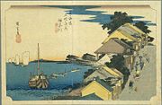
53 Stations of the Tokaido
The are the rest areas along the Tōkaidō, which was a coastal route that ran from Nihonbashi in Edo to Sanjō Ōhashi in Kyoto.-Stations of the Tōkaidō:...
of the Tōkaidō
Tokaido (road)
The ' was the most important of the Five Routes of the Edo period, connecting Edo to Kyoto in Japan. Unlike the inland and less heavily travelled Nakasendō, the Tōkaidō travelled along the sea coast of eastern Honshū, hence the route's name....
. It is located in Kanagawa-ku
Kanagawa-ku, Yokohama
is one of the 18 wards of the city of Yokohama in Kanagawa Prefecture, Japan. As of 2010, the ward had an estimated population of 230,401 and a density of 9,650 persons per km²...
in the present-day city of Yokohama, Kanagawa Prefecture
Kanagawa Prefecture
is a prefecture located in the southern Kantō region of Japan. The capital is Yokohama. Kanagawa is part of the Greater Tokyo Area.-History:The prefecture has some archaeological sites going back to the Jōmon period...
, Japan
Japan
Japan is an island nation in East Asia. Located in the Pacific Ocean, it lies to the east of the Sea of Japan, China, North Korea, South Korea and Russia, stretching from the Sea of Okhotsk in the north to the East China Sea and Taiwan in the south...
. It is close to Kanagawa Port. Many of its historical artifacts were destroyed by the Great Kantō Earthquake
1923 Great Kanto earthquake
The struck the Kantō plain on the Japanese main island of Honshū at 11:58:44 am JST on September 1, 1923. Varied accounts hold that the duration of the earthquake was between 4 and 10 minutes...
and bombings during World War II
World War II
World War II, or the Second World War , was a global conflict lasting from 1939 to 1945, involving most of the world's nations—including all of the great powers—eventually forming two opposing military alliances: the Allies and the Axis...
.
History
Kanagawa-juku was established parallel to Kanagawa Port and it flourished as part of the route that goods traveled on the way to Sagami ProvinceSagami Province
was an old province in the area that is today the central and western Kanagawa prefecture. It was sometimes called . Sagami bordered on Izu, Musashi, Suruga provinces; and had access to the Pacific Ocean through Sagami Bay...
. Though the area had officially been designated as the place for the port to be opened, it was actually opened on the opposite shore in what is now Naka-ku
Naka-ku, Yokohama
is one of the 18 wards of the city of Yokohama in Kanagawa Prefecture, Japan. As of 2010, the ward had an estimated population of 146,563and a density of 7,080 persons per km². The total area was 20.86 km².-Geography:...
, Yokohama.
After the country was opened to international trade
International trade
International trade is the exchange of capital, goods, and services across international borders or territories. In most countries, such trade represents a significant share of gross domestic product...
, the center of commerce was moved to the opposite shore as well. In 1889, the town of Kanagawa was established, and it eventually merged into Yokohama in 1901.