
Kamloops Lake
Encyclopedia

British Columbia
British Columbia is the westernmost of Canada's provinces and is known for its natural beauty, as reflected in its Latin motto, Splendor sine occasu . Its name was chosen by Queen Victoria in 1858...
, Canada
Canada
Canada is a North American country consisting of ten provinces and three territories. Located in the northern part of the continent, it extends from the Atlantic Ocean in the east to the Pacific Ocean in the west, and northward into the Arctic Ocean...
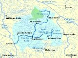
is situated on the Thompson River
Thompson River
The Thompson River is the largest tributary of the Fraser River, flowing through the south-central portion of British Columbia, Canada. The Thompson River has two main branches called the South Thompson and the North Thompson...
just west of Kamloops. The lake is 1.6 km wide, 29 km long, and up to 152 m deep. The community of Savona
Savona, British Columbia
Savona is a small community located at the west end of Kamloops Lake, where the Thompson River exits it. It is approximately halfway between Kamloops and Cache Creek along the Trans-Canada Highway...
is located at the west end of the lake, with the city of Kamloops located a few miles east of the head of the lake at the confluence of the North and South Thompson Rivers.
The lake is bounded on all sides by steep embankments with level areas only near creek deltas and around the inlet and outlet. The surrounding land is mostly uninhabited and within the dry belt interior grasslands composed of bunchgrass and sagebrush
Sagebrush
Sagebrush is a common name of a number of shrubby plant species in the genus Artemisia native to western North America;Or, the sagebrush steppe ecoregion, having one or more kinds of sagebrush, bunchgrasses and others;...
with pockets of Douglas fir, Ponderosa pine
Ponderosa Pine
Pinus ponderosa, commonly known as the Ponderosa Pine, Bull Pine, Blackjack Pine, or Western Yellow Pine, is a widespread and variable pine native to western North America. It was first described by David Douglas in 1826, from eastern Washington near present-day Spokane...
and spruce
Spruce
A spruce is a tree of the genus Picea , a genus of about 35 species of coniferous evergreen trees in the Family Pinaceae, found in the northern temperate and boreal regions of the earth. Spruces are large trees, from tall when mature, and can be distinguished by their whorled branches and conical...
.
Kamloops Lake is also a widening and deepening of the Thompson River which enters at the east end and exits at the west end. The limnology of the lake is controlled by the Thompson River which has large fluctuations in annual flow with over 60% occurring in the early summer during freshet
Freshet
A freshet can refer to one of two things:* A flood resulting from heavy rain or a spring thaw. Whereas heavy rain often causes a flash flood, a spring thaw event is generally a more incremental process, depending upon local climate and topography...
(May to July). Lake levels rise naturally as much as 30 feet (9.1 m) from high season in June to low season, and beach areas expand by as much as 200 feet (61 m) in the summer as lake levels recede after freshet.
Bulk residence times are very short (the time it takes for the water in the lake to be replaced with new water), ranging from 20 days to 340 days with a mean of 60 days. The water of Kamloops Lake meets or exceeds Canadian Drinking Water Standards. Because Kamloops Lake is fed by both the North Thompson River and the South Thompson River (the South Thompson River drains from the very warm Shuswap Lakes), Kamloops Lake is a very warm lake and is quickly becoming a popular boating and recreational area. On the north side of the lake is Fredrick and on the south side of the lake are residential subdivisions such as Cherry Creek and also the Tobiano resort community. A boat launch, trestle and gas dock has been built at Tobiano making it the only location on Kamloops Lake with these facilities. Boat launches also exist in Savona and Kamloops but their operational use is limited in the months of low water.
Physical dimensions
- Water level: Unregulated
- Normal range of annual water level fluctuation: 5 m