

K-58 (Kansas highway)
Encyclopedia
State highway
State highway, state road or state route can refer to one of three related concepts, two of them related to a state or provincial government in a country that is divided into states or provinces :#A...
in the U.S. state
U.S. state
A U.S. state is any one of the 50 federated states of the United States of America that share sovereignty with the federal government. Because of this shared sovereignty, an American is a citizen both of the federal entity and of his or her state of domicile. Four states use the official title of...
of Kansas
Kansas
Kansas is a US state located in the Midwestern United States. It is named after the Kansas River which flows through it, which in turn was named after the Kansa Native American tribe, which inhabited the area. The tribe's name is often said to mean "people of the wind" or "people of the south...
.
It is one of the newer state highways in Kansas formed by 2005 when K-57 was truncated at K-4
K-4 (Kansas highway)
K-4 is the longest designated state highway in Kansas traversing from north of Scott City at US-83 to US-59 near Nortonville in northeast Kansas. A segment of the highway in McPherson County overlaps Interstate 135, and a section in Topeka runs concurrent with Interstate 70.-Western Kansas:K-4...
in Dwight
Dwight, Kansas
Dwight is a city in Morris County, Kansas, United States. As of the 2010 census, the city population was 272.-History:In 1887, the Chicago, Kansas and Nebraska Railway built a main line from Topeka through Dwight to Herington...
.
The route changes were made because of K-57's long concurrencies with K-4, K-177
K-177 (Kansas highway)
K-177 is a state highway in central Kansas. It runs from US-54 near El Dorado to Manhattan, passing through the Flint Hills. It is part of the Flint Hills Scenic Byway and the Prairie Parkway.-Route description:...
, US-50 and K-99
K-99 (Kansas highway)
K-99 is a Kansas state highway that runs north–south through the eastern part of the state.K-99 has its northern terminus near Summerfield at the Nebraska state line and its southern end south of Chautauqua where it crosses the Oklahoma border and becomes State Highway 99...
.
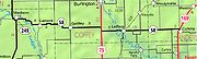
K-58 begins at K-99 in Madison and runs east through Lamont
Lamont, Kansas
Lamont is an unincorporated community in northeastern Greenwood County, Kansas, United States. It lies along K-58 northeast of the city of Eureka, the county seat of Greenwood County. Its elevation is 1,125 feet , and it is located at...
and Gridley
Gridley, Kansas
Gridley is a city in Coffey County, Kansas, United States. The population was 372 at the 2000 census.-Geography:Gridley is located at ....
. After a short concurrency with US-75, it goes through LeRoy before ending at US-169 near Colony
Colony, Kansas
Colony is a city in Anderson County, Kansas, United States. As of the 2010 census, the city population was 408.-Geography:Colony is located at . According to the United States Census Bureau, the city has a total area of , all of it land.-Demographics:As of the census of 2000, there were 397...
.
Former designation
K-58 originally was formed in 1927, with its western terminus at US-50 northeast of LenexaLenexa, Kansas
Lenexa is a city in the central part of Johnson County, located in northeast Kansas, in the central United States of America. As of the 2010 census, the city population was 48,190. As a satellite city of Kansas City, Kansas, Lenexa is included in the Kansas City Metropolitan Area...
, and its eastern terminus at US-73E, or Metcalf Avenue.
By 1936, US-73E was renumbered as US-69, and K-58 was realigned. It began at US-50 near Lenexa, Kansas
Lenexa, Kansas
Lenexa is a city in the central part of Johnson County, located in northeast Kansas, in the central United States of America. As of the 2010 census, the city population was 48,190. As a satellite city of Kansas City, Kansas, Lenexa is included in the Kansas City Metropolitan Area...
, and followed Metcalf Avenue/US-69 north to Southwest Boulevard (now Merriam Drive). It turned east to Antone Road (now 34th Street) near the Argentine
Argentine, Kansas
Argentine is a community of Kansas City, Kansas, located in the southern part of Wyandotte County. It is bordered on the west by the Turner community, on the east by the Rosedale community, on the south by Johnson County, and on the north by Armourdale community and by the Kansas River. Argentine...
neighborhood of Kansas City, Kansas
Kansas City, Kansas
Kansas City is the third-largest city in the state of Kansas and is the county seat of Wyandotte County. It is a suburb of Kansas City, Missouri, and is the third largest city in the Kansas City Metropolitan Area. The city is part of a consolidated city-county government known as the "Unified...
, where it headed north to Strong Avenue. It turned east on Strong, and headed north on (what is today) the Goddard Viaduct. It then headed east on Argentine Boulevard, crossed the Kansas River
Kansas River
The Kansas River is a river in northeastern Kansas in the United States. It is the southwestern-most part of the Missouri River drainage, which is in turn the northwestern-most portion of the extensive Mississippi River drainage. Its name come from the Kanza people who once inhabited the area...
on the Argentine Bridge
Argentine Bridge
The Argentine Bridge was a one lane, thru-truss bridge over the Kansas River in Kansas City, Kansas.It was built in 1908, and removed in 1959, after the 18th Street Expressway Bridge was built to the east of it....
, and headed north on 18th Street to K-5
K-5 (Kansas highway)
K-5 is a state highway in northeastern Kansas. Remaining completely in the Kansas City metropolitan area, it connects Leavenworth to Kansas City.-Route description:...
, the Quindaro Boulevard, where it ended.
In 1956, the 18th Street Expressway
18th Street Expressway
The 18th Street Expressway is a freeway in Kansas City, Kansas that runs from Interstate 35 north to Interstate 70/U.S. Route 40. It carries the U.S...
was completed, allowing a rerouting of US-69 off of then Southwest Boulevard. A new toll bridge over the Kansas River
Kansas River
The Kansas River is a river in northeastern Kansas in the United States. It is the southwestern-most part of the Missouri River drainage, which is in turn the northwestern-most portion of the extensive Mississippi River drainage. Its name come from the Kanza people who once inhabited the area...
was built for the expressway, and the Argentine Bridge bridge was demolished. K-58 then was rerouted to leave Metcalf and follow east on Shawnee Mission Parkway
Shawnee Mission Parkway
Shawnee Mission Parkway is a stretch of roadway in Johnson County, Kansas and Jackson County, Missouri . Its western terminus at K-7 in Shawnee, Kansas and its eastern terminus at Ward Parkway in Kansas City, Missouri...
, then follow north on the 18th Street Expressway to K-5.
Due to the rerouting of US-50 out of downtown Mission, Kansas
Mission, Kansas
Mission is a city in Johnson County, Kansas, United States. The population was 9,727 at the 2000 census. The city is a first-tier suburb in the Kansas City Metro. In 2003, Mission absorbed the neighboring city of Countryside.- History :...
, K-158
K-158 (Kansas highway)
K-158 was a Kansas highway that ran entirely through Mission, Kansas. It was turned back to the local authorities in 1979.K-158 was created when US-50 was rerouted on to the newly-built Shawnee Mission Parkway in the 1950s...
was created. It ran on Johnson Drive from 18th Street Expressway to Metcalf.
In 1979, K-58 and K-158 were given to the cities of Roeland Park
Roeland Park, Kansas
Roeland Park is a city in Johnson County, Kansas, United States. The population was 6,817 at the 2000 census.-History:The City of Roeland Park was originally named after John Roe, an immigrant from Ireland who settled on in 1883, part of which Roeland Park now stands...
, Overland Park, and Mission, Kansas
Mission, Kansas
Mission is a city in Johnson County, Kansas, United States. The population was 9,727 at the 2000 census. The city is a first-tier suburb in the Kansas City Metro. In 2003, Mission absorbed the neighboring city of Countryside.- History :...
. K-58 became the first of several highways to be turned back, shortened, or realigned in Kansas City, as the Interstate highways were being completed.
In 1996, extensive reconstruction was completed in Roeland Park, Kansas
Roeland Park, Kansas
Roeland Park is a city in Johnson County, Kansas, United States. The population was 6,817 at the 2000 census.-History:The City of Roeland Park was originally named after John Roe, an immigrant from Ireland who settled on in 1883, part of which Roeland Park now stands...
, where K-58 formerly traveled. As a result, the former Skyline Drive interchange was transformed into an at-grade intersection, also eliminating the Skyline tunnel underneath the expressway. When this was completed, Johnson County, Kansas
Johnson County, Kansas
Johnson County is a county located in northeast Kansas, in the central United States. The county is largely suburban, being part of the Kansas City metropolitan area, and containing many of its affluent southwestern suburbs. As of the 2010 census, the county population was 544,179. Its county...
renamed the segment from Shawnee Mission Parkway
Shawnee Mission Parkway
Shawnee Mission Parkway is a stretch of roadway in Johnson County, Kansas and Jackson County, Missouri . Its western terminus at K-7 in Shawnee, Kansas and its eastern terminus at Ward Parkway in Kansas City, Missouri...
to I-35 as "Roe Boulevard", a continuation of "Roe Avenue" from Fairway, Kansas
Fairway, Kansas
Fairway is a city in Johnson County, Kansas, United States. It is a suburb of Kansas City, Missouri. The population was 3,952 at the 2000 census.-Geography:Fairway is located at...
to I-35.
Junction list
{|class=wikitable!County
!Location
!Mile
!Destination
!Notes
|-
|Greenwood County
Greenwood County, Kansas
Greenwood County is a county located in Southeast Kansas, in the Central United States. As of the 2010 census, the county population was 6,689...
|
|0.000
|
|Western terminus
|-
|Coffey
Coffey County, Kansas
Coffey County is a county located in East Central Kansas, in the Central United States. As of the 2010 census, the county population was 8,601...
|
|13.182
|
|
|-
|Anderson
Anderson County, Kansas
Anderson County is a county located in East Central Kansas, in the Central United States. As of the 2010 census, the county population was 8,102...
|
|8.109
|
|Eastern terminus