
Joondalup railway station, Perth
Encyclopedia
Joondalup Station is a Transperth
train and bus interchange located 26 kilometres (16.2 mi) north-northwest of Perth railway station
in Western Australia
, on the Joondalup Line.
( ) and Grand Boulevard, making it the first station on the Joondalup Line heading north that is not located in the central reservation of the Mitchell Freeway
( ). The Lakeside Joondalup Shopping City
adjoins the station to the northwest and features a number of major world-wide retailers. Lake Joondalup
is about a .75 km walk from the station.
network, a hybrid metro-commuter rail system with five lines in metropolitan Perth. As such, it hosts trains travelling southbound to central Perth
and northbound to Clarkson
station. Two stopping patterns serve Joondalup station: all stations and C.
In the inbound direction, all stations trains take about 29 minutes, averaging 53.8 km/h (33.4 mph), to travel from Joondalup to Perth. C-pattern trains make all stops to Stirling and then express to Perth, taking 27 minutes at an average of 57.8 km/h (35.9 mph).
In the outbound direction, an all stations train takes about seven minutes, averaging 51.4 km/h (31.9 mph), to travel from Joondalup to Clarkson. C-pattern trains stop at all stations except Leederville and Glendalough; this has no effect for passengers travelling northbound.
precinct.
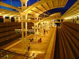
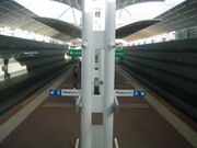
Joondalup station lies in an open cut north of Collier Place with a busway surrounding the east, west, and northern sides of the station. The majority of parking available at the station is adjacent to the western side of the busway, but some is available to the east. Access to the station is provided by concourses on the northern and southern ends of the platform at street level; as Joondalup is a closed station, there are SmartRider
faregates at these locations. Upon passing through the faregates, passengers are able to descend to track level using escalators, staircases, or lifts. At track level, Joondalup utilises a simple island platform layout with two tracks, one on each side. Platform 1 is used by trains heading towards central Perth whilst platform 2 is used by trains bound for Clarkson.
Transperth
Transperth is the brand name of the public transport system in Perth, Western Australia. It is operated by the Public Transport Authority.-History:...
train and bus interchange located 26 kilometres (16.2 mi) north-northwest of Perth railway station
Perth railway station
Perth Station including Perth Underground is the largest railway station in Perth, Western Australia, and functions as an interchange between the Transperth Trains Armadale / Thornlie, Fremantle, Joondalup, Mandurah and Midland railway lines, as well as the Transwa Australind.-History:The Victorian...
in Western Australia
Western Australia
Western Australia is a state of Australia, occupying the entire western third of the Australian continent. It is bounded by the Indian Ocean to the north and west, the Great Australian Bight and Indian Ocean to the south, the Northern Territory to the north-east and South Australia to the south-east...
, on the Joondalup Line.
Location
Joondalup station is located in downtown Joondalup between two major thoroughfares, Joondalup DriveJoondalup Drive
Joondalup Drive is a main road in the city of Perth, Western Australia. The road cuts through the City of Joondalup's central business district and extends for a few kilometres out towards neighbouring residential suburbs...
(
) and Grand Boulevard, making it the first station on the Joondalup Line heading north that is not located in the central reservation of the Mitchell FreewayMitchell Freeway
Mitchell Freeway is a long freeway in Perth, Western Australia, linking Perth's central business district with its outer northern suburbs. It is allocated Route 2 for its entire length and is named after former state Premier and Governor Sir James Mitchell....
(
). The Lakeside Joondalup Shopping CityLakeside Joondalup Shopping City
Lakeside Joondalup Shopping City is a major shopping centre, located in Joondalup, a northern suburb of Perth. It is located next to Grand Boulevard, approximately from Joondalup railway station.-History and development:...
adjoins the station to the northwest and features a number of major world-wide retailers. Lake Joondalup
Lake Joondalup
Lake Joondalup is a medium sized lake in Perth, Western Australia. It is located in the Perth northern suburbs of Joondalup, Wanneroo, and Edgewater. It is a nature reserve and part of the Yellagonga Regional Park.-Features:...
is about a .75 km walk from the station.
History
The station was built in 1990-1992 for the original opening of the Joondalup Line. Prior to the construction of Currambine station in March 1993, Joondalup was the end of the line.Service
Joondalup is on the Joondalup Line of the Transperth TrainsTransperth Trains
Transperth Trains is a division of the Public Transport Authority of Western Australia. It is responsible for operating Perth’s urban passenger rail system, as part of the Transperth network.- Lines :...
network, a hybrid metro-commuter rail system with five lines in metropolitan Perth. As such, it hosts trains travelling southbound to central Perth
Perth railway station
Perth Station including Perth Underground is the largest railway station in Perth, Western Australia, and functions as an interchange between the Transperth Trains Armadale / Thornlie, Fremantle, Joondalup, Mandurah and Midland railway lines, as well as the Transwa Australind.-History:The Victorian...
and northbound to Clarkson
Clarkson railway station, Perth
Clarkson is a Transperth bus and train station located north of Perth, Western Australia, in the suburb of Clarkson. It presently serves as the terminus for the Joondalup Line. It is located east of Ocean Keys Shopping Centre....
station. Two stopping patterns serve Joondalup station: all stations and C.
In the inbound direction, all stations trains take about 29 minutes, averaging 53.8 km/h (33.4 mph), to travel from Joondalup to Perth. C-pattern trains make all stops to Stirling and then express to Perth, taking 27 minutes at an average of 57.8 km/h (35.9 mph).
In the outbound direction, an all stations train takes about seven minutes, averaging 51.4 km/h (31.9 mph), to travel from Joondalup to Clarkson. C-pattern trains stop at all stations except Leederville and Glendalough; this has no effect for passengers travelling northbound.
Station layout
In contrast to almost all of Perth's railway stations, Joondalup is one of the few sunken stations in the Transperth Trains system. In many respects, its design is quite similar to that of Subiaco on the Fremantle Line in that it is below ground in a growing transport-oriented developmentTransit-oriented development
A transit-oriented development is a mixed-use residential or commercial area designed to maximize access to public transport, and often incorporates features to encourage transit ridership...
precinct.
Joondalup station lies in an open cut north of Collier Place with a busway surrounding the east, west, and northern sides of the station. The majority of parking available at the station is adjacent to the western side of the busway, but some is available to the east. Access to the station is provided by concourses on the northern and southern ends of the platform at street level; as Joondalup is a closed station, there are SmartRider
SmartRider
SmartRider is Transperth's contactless electronic ticketing system using smartcard technology for the process of charging patrons for public transport in Western Australia....
faregates at these locations. Upon passing through the faregates, passengers are able to descend to track level using escalators, staircases, or lifts. At track level, Joondalup utilises a simple island platform layout with two tracks, one on each side. Platform 1 is used by trains heading towards central Perth whilst platform 2 is used by trains bound for Clarkson.
Bus stands
Buses are provided at Joondalup Interchange.| Route Number | Destination / Description | ||
| [17845] Stand 1 | |||
| 390 | to Banksia Grove Banksia Grove, Western Australia Banksia Grove is a suburb of Perth, Western Australia, located within the City of Wanneroo. Its postcode is 6031, and it was until the late 1990s part of Neerabup. The suburb is approximately 27km to Perth CBD, 9km from the coast and 5km from Joondalup CBD.... via Joondalup Drive and St Stephens Crescent |
||
| 391 | to Banksia Grove Banksia Grove, Western Australia Banksia Grove is a suburb of Perth, Western Australia, located within the City of Wanneroo. Its postcode is 6031, and it was until the late 1990s part of Neerabup. The suburb is approximately 27km to Perth CBD, 9km from the coast and 5km from Joondalup CBD.... via Joondalup Drive and Millendon Drive |
||
| [17846] Stand 2 | |||
| 904 | Rail Replacement Service to Perth | ||
| 904 | Rail Replacement Service to Clarkson | ||
| [17847] Stand 3 | |||
| 467 | to Whitfords Station via Ashby and Hocking | ||
| 468 | to Whitfords Station via Wanneroo Road | ||
| [17848] Stand 4 | |||
| 470 | to Burns Beach Burns Beach, Western Australia Burns Beach is a suburb of Perth, Western Australia, located north of Perth's central business district at the northern fringe of the City of Joondalup... via Iluka |
||
| 471 | to Kinross Kinross, Western Australia Kinross is a small suburb in the City of Joondalup located in the northern suburbs of Perth, Australia. Kinross was constructed around 1992-3 in various stages. It is bordered by Neerabup National Park, and is the City of Joondalup's most northerly suburb.... via Currambine |
||
| 473 | to Kinross via Blue Mountain Drive | ||
| 474 | to Clarkson Station Clarkson railway station, Perth Clarkson is a Transperth bus and train station located north of Perth, Western Australia, in the suburb of Clarkson. It presently serves as the terminus for the Joondalup Line. It is located east of Ocean Keys Shopping Centre.... via Kinross |
||
| [17849] Stand 5 | |||
| 464 | to Whitfords Station via Heathridge and Eddystone Avenue | ||
| 465 | to Whitfords Station via Trappers Drive | ||
| 466 | to Whitfords Station via Timberlane Drive | ||
| [17850] Stand 6 | |||
| 460 | to Whitfords Station via Shenton Avenue and Oceanside Prom | ||
| 461 | to Whitfords Station via Shenton Avenue and Marmion Avenue Marmion Avenue Marmion Avenue is a major arterial road in Perth, Western Australia, designated State Route 71.It runs through the northern coastal suburbs of Perth from the end of West Coast Highway in Trigg and Karrinyup, to the outer northern suburb of Yanchep... |
||
| [17851] Stand 7 | |||
| 462 | to Whitfords Station via Hodges Drive and Marmion Avenue Marmion Avenue Marmion Avenue is a major arterial road in Perth, Western Australia, designated State Route 71.It runs through the northern coastal suburbs of Perth from the end of West Coast Highway in Trigg and Karrinyup, to the outer northern suburb of Yanchep... |
||
| 463 | to Whitfords Station via Heathridge | ||
| 681 | to Burswood Entertainment Complex Burswood Entertainment Complex The Burswood Entertainment Complex is located on the Swan River near the city of Perth, Western Australia, and is owned by Crown Limited. The complex includes a 24-hour casino, seven restaurants, eight bars, a nightclub, two international hotels , a Convention Centre, Theatre and the Burswood Dome... |
||
| [17852] Stand 8 | |||
| 10 Joondalup CAT | Joondalup Circular Service (anti-clockwise) | ||
| 11 Joondalup CAT | Joondalup Circular Service (clockwise) | ||
| 13 Joondalup CAT | ECU Joondalup Circular Service (Monday to Thursday ECU days only) | ||
| [17853] Stand 9 | |||
| School specials | |||
See also
- Veolia TransdevSouthern Coast TransitSouthern Coast Transit, established in 1995, is a transport company that has operated 320 buses in south-western Perth, Australia since 1996 under contracts with the Department of Transport / Public Transport Authority.-History:...