

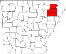
Jonesboro-Paragould combined statistical area
Encyclopedia
Arkansas
Arkansas is a state located in the southern region of the United States. Its name is an Algonquian name of the Quapaw Indians. Arkansas shares borders with six states , and its eastern border is largely defined by the Mississippi River...
. The CSA consists of the Jonesboro Metropolitan Statistical Area
Jonesboro metropolitan area
The Jonesboro Metropolitan Statistical Area, as defined by the United States Census Bureau, is an area consisting of two counties – Craighead and Poinsett – in northeast Arkansas, anchored by the city of Jonesboro. As of the 2000 census, the MSA had a population of 107,762...
and the Paragould Micropolitan Statistical Area. As of the 2000 census
United States Census, 2000
The Twenty-second United States Census, known as Census 2000 and conducted by the Census Bureau, determined the resident population of the United States on April 1, 2000, to be 281,421,906, an increase of 13.2% over the 248,709,873 persons enumerated during the 1990 Census...
, the CSA had a population of 145,093 (though a July 1, 2009 estimate placed the population at 161,135).
Counties
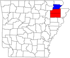
- CraigheadCraighead County, ArkansasCraighead County is a county located in the U.S. state of Arkansas. As of the 2010 census, the population was 96,443. It is included in the Jonesboro, Arkansas Metropolitan Statistical Area. Craighead County is Arkansas's 58th county, formed on February 19, 1859, and named for state Senator Thomas...
- Greene
- Poinsett
Places with 1,000 to 10,000 inhabitants
- BayBay, ArkansasBay is a city in Craighead County, Arkansas, United States. The population was 1,800 at the 2000 census. It is included in the Jonesboro, Arkansas Metropolitan Statistical Area.-Geography:Bay is located at ....
- BonoBono, ArkansasBono is a city in Craighead County, Arkansas, United States. The population was 1,512 at the 2000 census. Population estimate as of 2008 was 1,599. It is included in the Jonesboro, Arkansas Metropolitan Statistical Area...
- BrooklandBrookland, ArkansasBrookland is a town in Craighead County, Arkansas, United States. The population was 1,332 at the 2000 census. It is included in the Jonesboro, Arkansas Metropolitan Statistical Area.-Geography:Brookland is located at ....
- CarawayCaraway, ArkansasCaraway is a town in Craighead County, Arkansas, United States. The population was 1,349 at the 2000 census. It is included in the Jonesboro, Arkansas Metropolitan Statistical Area.-Geography:Caraway is located at ....
- HarrisburgHarrisburg, ArkansasHarrisburg is a city in Poinsett County, Arkansas, United States. The population was 2,192 at the 2000 census. It is included in the Jonesboro, Arkansas Metropolitan Statistical Area...
- Lake CityLake City, ArkansasLake City is a town in Craighead County, Arkansas in the United States, along the St. Francis River. The population is 2,082 according to the 2010 census. It is included in the Jonesboro, Arkansas Metropolitan Statistical Area...
- LepantoLepanto, ArkansasLepanto is a city in Poinsett County, Arkansas, United States. The population was 2,133 at the 2000 census. It is included in the Jonesboro, Arkansas Metropolitan Statistical Area...
- Marked TreeMarked Tree, ArkansasMarked Tree is a city in Poinsett County, Arkansas in the United States, along the St. Francis River, at the mouth of the Little River. The population was 2,800 at the 2000 census. It is included in the Jonesboro, Arkansas Metropolitan Statistical Area....
- MarmadukeMarmaduke, ArkansasMarmaduke is a city in Greene County, Arkansas, United States. The population was 1,158 at the 2000 census.- History :The town of Marmaduke was named for Confederate Major General John Sappington Marmaduke, who later served as Governor of Missouri. Marmaduke was said to have established a camp for...
- MonetteMonette, ArkansasMonette is a city in Craighead County, Arkansas, United States. The population was 1,247 at the 2009 census. It is included in the Jonesboro, Arkansas Metropolitan Statistical Area.-Geography:Monette is located at ....
- TrumannTrumann, ArkansasTrumann is a city in Poinsett County, Arkansas, United States. The population was 6,889 at the 2000 census. It is included in the Jonesboro, Arkansas Metropolitan Statistical Area.-Geography:Trumann is located at ....
Places with less than 1,000 inhabitants
- Black OakBlack Oak, ArkansasBlack Oak is a town in Craighead County, Arkansas, USA. The population was 286 at the 2000 census. It is included in the Jonesboro, Arkansas Metropolitan Statistical Area...
- CashCash, ArkansasCash is a town in Craighead County, Arkansas, United States. The population was 294 at the 2000 census. It is included in the Jonesboro, Arkansas Metropolitan Statistical Area.-Geography:Cash is located at ....
- DelaplaineDelaplaine, ArkansasDelaplaine is a town in Greene County, Arkansas, United States. The population was 127 at the 2000 census.-History:Delaplaine was incorporated as a town in April 1912 but has a history that dates back to the time of the French explorations. Early settlers found remains of a French-Indian trading...
- EgyptEgypt, ArkansasEgypt is a town in Craighead County, Arkansas, United States. The population was 101 at the 2000 census. It is included in the Jonesboro, Arkansas Metropolitan Statistical Area.-Geography:Egypt is located at ....
- FisherFisher, ArkansasFisher is a town in Poinsett County, Arkansas, United States. The population was 265 at the 2000 census. It is included in the Jonesboro, Arkansas Metropolitan Statistical Area.-Geography:Fisher is located at ....
- LafeLafe, ArkansasLafe is a town in Greene County, Arkansas on Crowley's Ridge. The population was 385 at the 2000 census.- History :The first settler of Lafe was Mr. Herman Toelken, a German immigrant who had been living in New Haven, Missouri and was seeking new opportunities in an unsettled area...
- Oak Grove HeightsOak Grove Heights, ArkansasOak Grove Heights is a town in Greene County, Arkansas, United States. The population was 727 at the 2000 census.-Geography:Oak Grove Heights is located at ....
- TyronzaTyronza, ArkansasTyronza is a town in Poinsett County, Arkansas, United States. The population was 762 at the 2010 census. It is included in the Jonesboro, Arkansas Metropolitan Statistical Area.-Geography:Tyronza is located at ....
- WaldenburgWaldenburg, ArkansasWaldenburg is a town in Poinsett County, Arkansas, United States. The population was 80 at the 2000 census. It is included in the Jonesboro, Arkansas Metropolitan Statistical Area.-Geography:Waldenburg is located at ....
- WeinerWeiner, ArkansasWeiner is a city in Poinsett County, Arkansas, United States. The population was 760 at the 2000 census. It is included in the Jonesboro, Arkansas Metropolitan Statistical Area.-Geography:Weiner is located at ....
Unincorporated places
|
Payneway, Arkansas Payneway is an unincorporated community in Little River Township, Poinsett County, Arkansas, United States. It is located west of Marked Tree near the intersection of Arkansas Highway 463 and Arkansas Highway 14.... Rivervale, Arkansas Rivervale is an unincorporated community in Poinsett County, Arkansas, United States, approximately five miles north of Lepanto.The Rivervale Tunnel, an engineering project in which one river flows under another, is located near Rivervale.-External links:*... Walcott, Arkansas Walcott is an unincorporated community in Greene County, Arkansas, United States. Walcott is located at the junction of Arkansas Highway 141 and Arkansas Highway 168 west of Paragould. Walcott has a post office with ZIP code 72474.... Whitehall, Poinsett County, Arkansas Whitehall, Arkansas is an unincorporated community in Scott Township, Poinsett County, Arkansas, United States. Whitehall is located at the intersection of Arkansas Highway 1 and Arkansas Highway 214.... |
Demographics
As of the censusCensus
A census is the procedure of systematically acquiring and recording information about the members of a given population. It is a regularly occurring and official count of a particular population. The term is used mostly in connection with national population and housing censuses; other common...
of 2000, there were 145,093 people, 57,077 households, and 40,029 families residing within the CSA. The racial makeup of the CSA was 91.68% White, 5.70% African American, 0.34% Native American, 0.41% Asian, 0.02% Pacific Islander, 0.78% from other races
Race (United States Census)
Race and ethnicity in the United States Census, as defined by the Federal Office of Management and Budget and the United States Census Bureau, are self-identification data items in which residents choose the race or races with which they most closely identify, and indicate whether or not they are...
, and 1.08% from two or more races. Hispanic or Latino of any race were 1.75% of the population.
The median income for a household in the CSA was $29,937, and the median income for a family was $36,754. Males had a median income of $28,178 versus $20,228 for females. The per capita income
Per capita income
Per capita income or income per person is a measure of mean income within an economic aggregate, such as a country or city. It is calculated by taking a measure of all sources of income in the aggregate and dividing it by the total population...
for the CSA was $15,527.