
Jakobshavn Isbræ
Encyclopedia
Jakobshavn Isbræ, also known as the Jakobshavn Glacier and Sermeq Kujalleq (in Greenlandic) is a large outlet glacier in West Greenland
. It is located near the Greenlandic town of Ilulissat
and ends at the sea in the Ilulissat Icefjord.
Jakobshavn Isbræ drains 6.5% of the Greenland ice sheet
and produces around 10% of all Greenland iceberg
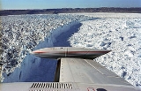
s. Some 35 billion tonnes of icebergs calve off and pass out of the fjord
every year. Icebergs breaking from the glacier
are often so large (up to a kilometer in height) that they are too tall to float down the fjord and lie stuck on the bottom of its shallower areas, sometimes for years, until they are broken up by the force of the glacier and icebergs further up the fjord. Studied for over 250 years, Jakobshavn Isbræ has helped develop our understanding of climate change
and icecap glaciology
.
referred to it as Jakobshavn Isstrøm (Danish for Jakobshavn Ice Stream
).
It is now most commonly known and recognised in the international scientific literature (by glaciologists) as Jakobshavn Isbræ. Isbræ is Danish for glacier. It is also commonly known by the anglicised version, Jakobshavn Glacier.
The local name for this glacier is Sermeq Kujalleq, where sermeq is Greenlandic for glacier and kujalleq means southern. It lies south of the town Ilulissat
(formerly Jakobshavn). This name is becoming more commonly used internationally, particularly as Greenlandic (Kalaallisut) became the sole official language of Greenland
in June 2009. Due to this, the glacier is now referred to by its local name as part of the Ilulissat Icefjord world heritage site, which includes the downstream end of the glacier.
There is evidence that people have inhabited the area around the glacier for up to 4000 years. The recently abandoned settlement of Sermermiut (Which means 'place of the glacier people') lies just to the north of the glacier, much nearer than Ilulissat.
The glacier is sometimes referred to as Ilulissat Glacier. This form simply replaces Jakobshavn with Ilulissat because of the change in the name of the town, while Sermeq Ilulissat is not the Greenlandic name for the glacier. Therefore this version has not caught on widely in scientific literature and is not the official local name either.
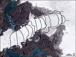 Jakobshavn is one of the fastest moving glaciers, flowing at its terminus at speeds of around 20 metres per day. The speed of Jakobshavn Isbræ varied between 5700 and 12600 metres per year between 1992 and 2003. The ice stream's speed-up and near-doubling of ice flow from land into the ocean has increased the rate of sea level rise by about .06 millimeters (about .002 inches) per year, or roughly 4 percent of the 20th century rate of sea level rise. Jakobshavn Isbrae, retreated 30 km from 1850–1964, followed by a stationary front for 35 years. Jakobshavn has the highest mass flux of any glacier draining the Greenland Ice Sheet
. The glacier terminus region also had a consistent velocity of 20 meters/day (maximum of 26 m in glacier center), from season to season and year to year, the glacier seemed to be in balance from 1955-1985. After 1997 the glacier began to accelerate and thin rapidly, reaching an average velocity of 34 m/day in the terminus region. It also thinned at a rate of up to 15 m/year and retreated 5 km in six years. Jakobshavn has since slowed to near its pre-1997 speed, the terminus retreat is still occurring. On Jakobshavn the acceleration began at the calving
front and spread up-glacier 20 km in 1997 and up to 55 km inland by 2003. The position of this calving front, or terminus, fluctuated by 2.5 km around its annual mean position between 1950 and 1996. The first mechanism for explaining the change in velocity is the "Zwally effect" and is not the main mechanism, this relies on meltwater reaching the glacier base and reducing the friction through a higher basal water pressure. A moulin
is the conduit for the additional meltwater to reach the glacier base. This idea, proposed by Jay Zwally, was observed to be the cause of a brief seasonal acceleration of up to 20% on the Jakobshavns Glacier in 1998 and 1999 at Swiss Camp. The acceleration lasted 2–3 months and was less than 10% in 1996 and 1997 for example. They offered a conclusion that the “coupling between surface melting and ice-sheet flow provides a mechanism for rapid, large-scale, dynamic responses of ice sheets to climate warming”. The acceleration of the three glaciers had not occurred at the time of this study and they were not concluding or implying that the meltwater increase was the cause of the aforementioned acceleration. Examination of recent rapid supra-glacial lake
drainage documented short term velocity changes due to such events, but they had little significance to the annual flow of the large outlet glaciers.
The second mechanism is a "Jakobshavn effect", coined by Terry Hughes, where a small imbalance of forces caused by some perturbation can cause a substantial non-linear response. In this case an imbalance of forces at the calving front propagates up-glacier. Thinning causes the glacier to be more buoyant, even becoming afloat at the calving front, and is responsive to tidal changes. The reduced friction due to greater buoyancy allows for an increase in velocity. The reduced resistive force at the calving front is then propagated up glacier via longitudinal extension in what R. Thomas calls a backforce reduction. This mechanism is supported by the data indicating no significant seasonal velocity changes at the calving front and the acceleration propagating upglacier from the calving front. The cause of the thinning could be a combination of increased surface ablation and basal ablation as one report presents data that show a sudden increase in subsurface ocean temperature in 1997 along the entire west coast of Greenland, and suggests that the changes in Jakobshavn Isbræ are due to the arrival of relatively warm water originating from the Irminger Sea near Iceland. Recent large calving
events where the glacier produces icebergs have also been found to trigger earthquakes due to the icebergs scraping the bottom of the fjord.
Evidence also exists for a deep subglacial trench beneath the glacial outlet, identified through seismic reflection methods.
Greenland
Greenland is an autonomous country within the Kingdom of Denmark, located between the Arctic and Atlantic Oceans, east of the Canadian Arctic Archipelago. Though physiographically a part of the continent of North America, Greenland has been politically and culturally associated with Europe for...
. It is located near the Greenlandic town of Ilulissat
Ilulissat
Ilulissat is a town in the Qaasuitsup municipality in western Greenland, located approximately north of the Arctic Circle. With the population of 4,546 as of 2010, it is the third-largest settlement in Greenland, after Nuuk and Sisimiut....
and ends at the sea in the Ilulissat Icefjord.
Jakobshavn Isbræ drains 6.5% of the Greenland ice sheet
Greenland ice sheet
The Greenland ice sheet is a vast body of ice covering , roughly 80% of the surface of Greenland. It is the second largest ice body in the world, after the Antarctic Ice Sheet. The ice sheet is almost long in a north-south direction, and its greatest width is at a latitude of 77°N, near its...
and produces around 10% of all Greenland iceberg
Iceberg
An iceberg is a large piece of ice from freshwater that has broken off from a snow-formed glacier or ice shelf and is floating in open water. It may subsequently become frozen into pack ice...
s. Some 35 billion tonnes of icebergs calve off and pass out of the fjord
Fjord
Geologically, a fjord is a long, narrow inlet with steep sides or cliffs, created in a valley carved by glacial activity.-Formation:A fjord is formed when a glacier cuts a U-shaped valley by abrasion of the surrounding bedrock. Glacial melting is accompanied by rebound of Earth's crust as the ice...
every year. Icebergs breaking from the glacier
Glacier
A glacier is a large persistent body of ice that forms where the accumulation of snow exceeds its ablation over many years, often centuries. At least 0.1 km² in area and 50 m thick, but often much larger, a glacier slowly deforms and flows due to stresses induced by its weight...
are often so large (up to a kilometer in height) that they are too tall to float down the fjord and lie stuck on the bottom of its shallower areas, sometimes for years, until they are broken up by the force of the glacier and icebergs further up the fjord. Studied for over 250 years, Jakobshavn Isbræ has helped develop our understanding of climate change
Climate change
Climate change is a significant and lasting change in the statistical distribution of weather patterns over periods ranging from decades to millions of years. It may be a change in average weather conditions or the distribution of events around that average...
and icecap glaciology
Glaciology
Glaciology Glaciology Glaciology (from Middle French dialect (Franco-Provençal): glace, "ice"; or Latin: glacies, "frost, ice"; and Greek: λόγος, logos, "speech" lit...
.
Name
Jakobshavn has been a name used for this glacier in scientific literature since 1853 when Danish geologist Hinrich Johannes RinkHinrich Johannes Rink
Dr. Hinrich Johannes Rink was a Danish geologist, one of the pioneers of glaciology, and the first accurate describer of the inland ice of Greenland. Rink, who first came to Greenland in 1848, spent 16 winters and 22 summers in the Arctic region, and became notable for Greenland's development...
referred to it as Jakobshavn Isstrøm (Danish for Jakobshavn Ice Stream
Ice stream
An ice stream is a region of an ice sheet that moves significantly faster than the surrounding ice. Ice streams are a type of glacier. They are significant features of the Antarctic where they account for 10% of the volume of the ice...
).
It is now most commonly known and recognised in the international scientific literature (by glaciologists) as Jakobshavn Isbræ. Isbræ is Danish for glacier. It is also commonly known by the anglicised version, Jakobshavn Glacier.
The local name for this glacier is Sermeq Kujalleq, where sermeq is Greenlandic for glacier and kujalleq means southern. It lies south of the town Ilulissat
Ilulissat
Ilulissat is a town in the Qaasuitsup municipality in western Greenland, located approximately north of the Arctic Circle. With the population of 4,546 as of 2010, it is the third-largest settlement in Greenland, after Nuuk and Sisimiut....
(formerly Jakobshavn). This name is becoming more commonly used internationally, particularly as Greenlandic (Kalaallisut) became the sole official language of Greenland
Greenland
Greenland is an autonomous country within the Kingdom of Denmark, located between the Arctic and Atlantic Oceans, east of the Canadian Arctic Archipelago. Though physiographically a part of the continent of North America, Greenland has been politically and culturally associated with Europe for...
in June 2009. Due to this, the glacier is now referred to by its local name as part of the Ilulissat Icefjord world heritage site, which includes the downstream end of the glacier.
There is evidence that people have inhabited the area around the glacier for up to 4000 years. The recently abandoned settlement of Sermermiut (Which means 'place of the glacier people') lies just to the north of the glacier, much nearer than Ilulissat.
The glacier is sometimes referred to as Ilulissat Glacier. This form simply replaces Jakobshavn with Ilulissat because of the change in the name of the town, while Sermeq Ilulissat is not the Greenlandic name for the glacier. Therefore this version has not caught on widely in scientific literature and is not the official local name either.
Acceleration and retreat
Greenland ice sheet
The Greenland ice sheet is a vast body of ice covering , roughly 80% of the surface of Greenland. It is the second largest ice body in the world, after the Antarctic Ice Sheet. The ice sheet is almost long in a north-south direction, and its greatest width is at a latitude of 77°N, near its...
. The glacier terminus region also had a consistent velocity of 20 meters/day (maximum of 26 m in glacier center), from season to season and year to year, the glacier seemed to be in balance from 1955-1985. After 1997 the glacier began to accelerate and thin rapidly, reaching an average velocity of 34 m/day in the terminus region. It also thinned at a rate of up to 15 m/year and retreated 5 km in six years. Jakobshavn has since slowed to near its pre-1997 speed, the terminus retreat is still occurring. On Jakobshavn the acceleration began at the calving
Ice calving
Ice calving, also known as glacier calving or iceberg calving, is a form of ice ablation or ice disruption. It is the sudden release and breaking away of a mass of ice from a glacier, iceberg, ice front, ice shelf, or crevasse...
front and spread up-glacier 20 km in 1997 and up to 55 km inland by 2003. The position of this calving front, or terminus, fluctuated by 2.5 km around its annual mean position between 1950 and 1996. The first mechanism for explaining the change in velocity is the "Zwally effect" and is not the main mechanism, this relies on meltwater reaching the glacier base and reducing the friction through a higher basal water pressure. A moulin
Moulin (geology)
A moulin or glacier mill is a roughly circular, vertical to nearly vertical well-like shaft within the a glacier through which water enters it from the surface. The term is derived from the French word for mill....
is the conduit for the additional meltwater to reach the glacier base. This idea, proposed by Jay Zwally, was observed to be the cause of a brief seasonal acceleration of up to 20% on the Jakobshavns Glacier in 1998 and 1999 at Swiss Camp. The acceleration lasted 2–3 months and was less than 10% in 1996 and 1997 for example. They offered a conclusion that the “coupling between surface melting and ice-sheet flow provides a mechanism for rapid, large-scale, dynamic responses of ice sheets to climate warming”. The acceleration of the three glaciers had not occurred at the time of this study and they were not concluding or implying that the meltwater increase was the cause of the aforementioned acceleration. Examination of recent rapid supra-glacial lake
Supraglacial lake
A supraglacial lake is any pond of liquid water on the top of a glacier. Although these pools are , they may reach kilometers in diameter and be several meters deep...
drainage documented short term velocity changes due to such events, but they had little significance to the annual flow of the large outlet glaciers.
The second mechanism is a "Jakobshavn effect", coined by Terry Hughes, where a small imbalance of forces caused by some perturbation can cause a substantial non-linear response. In this case an imbalance of forces at the calving front propagates up-glacier. Thinning causes the glacier to be more buoyant, even becoming afloat at the calving front, and is responsive to tidal changes. The reduced friction due to greater buoyancy allows for an increase in velocity. The reduced resistive force at the calving front is then propagated up glacier via longitudinal extension in what R. Thomas calls a backforce reduction. This mechanism is supported by the data indicating no significant seasonal velocity changes at the calving front and the acceleration propagating upglacier from the calving front. The cause of the thinning could be a combination of increased surface ablation and basal ablation as one report presents data that show a sudden increase in subsurface ocean temperature in 1997 along the entire west coast of Greenland, and suggests that the changes in Jakobshavn Isbræ are due to the arrival of relatively warm water originating from the Irminger Sea near Iceland. Recent large calving
Calving
Calving may refer to:*Calving, the process of giving birth to a calf*Ice calving, the process by which an iceberg breaks off from an ice shelf or glacier...
events where the glacier produces icebergs have also been found to trigger earthquakes due to the icebergs scraping the bottom of the fjord.
Evidence also exists for a deep subglacial trench beneath the glacial outlet, identified through seismic reflection methods.
See also
- Extremes on EarthExtremes on EarthThis article describes extreme locations on Earth. Entries listed in bold are Earth-wide extremes.-Extreme elevations and temperatures per continent:This article describes extreme locations on Earth. Entries listed in bold are Earth-wide extremes....
- Extreme points of Earth
- Retreat of glaciers since 1850Retreat of glaciers since 1850The retreat of glaciers since 1850 affects the availability of fresh water for irrigation and domestic use, mountain recreation, animals and plants that depend on glacier-melt, and in the longer term, the level of the oceans...
- Glacial motionGlacial motionGlacial motion is the motion of glaciers, which can be likened to rivers of ice. It has played an important role in sculpting many landscapes. Most lakes in the world occupy basins scoured out by glaciers...
- Glacier mass balanceGlacier mass balanceCrucial to the survival of a glacier is its mass balance, the difference between accumulation and ablation . Climate change may cause variations in both temperature and snowfall, causing changes in mass balance. Changes in mass balance control a glacier's long term behavior and is the most...
- Helheim GlacierHelheim GlacierHelheim Glacier is one of Greenland's largest outlet glaciers. It accelerated from per year in 2000 to per year in 2005. Like many of Greenland's outlet glaciers it is the site of glacial earthquakes.-External links:...
- Kangerdlugssuaq GlacierKangerdlugssuaq GlacierKangerdlugssuaq Glacier is the largest glacier on the east coast of the Greenland ice sheet. It flows into the Denmark Strait.-External links:...
- Large igneous provinceLarge igneous provinceA Large Igneous Province is an extremely large accumulation of igneous rocks—intrusive, extrusive, or both—in the earth's crust...
- List of glaciers
- Sullorsuaq StraitSullorsuaq StraitSullorsuaq Strait is a strait on the western coast of Greenland.- Geography :It separates Nuussuaq Peninsula in the northeast from Qeqertarsuaq Island in the southwest. The strait waterway connects inner Disko Bay in the southeast with Baffin Bay in the northwest...
- West Greenland CurrentWest Greenland CurrentThe West Greenland Current is a weak cold water current that flows to the north along the west coast of Greenland. The current results from the movement of water flowing around the southernmost point of Greenland caused by the East Greenland Current....
- Bentley Subglacial TrenchBentley Subglacial TrenchThe Bentley Subglacial Trench is a vast topographic trench in Marie Byrd Land, West Antarctica, 80°S, 115°W. At 2,555 meters below sea level, it is the lowest point on the surface of the earth not covered by ocean, although it is covered by ice. Most people do not count it as the lowest point on...
External links
- Jakobshavn Glacier Flow Animation of the glacier by NASA.
- Researchers Witness Overnight Breakup, Retreat of Greenland Glacier - July 2010