
Iža
Encyclopedia
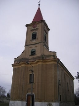
Iža is a village
in south-western Slovakia
.
 The biggest Roman
castellum
in present-day Slovakia was located in Celemantia
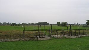
, an ancient settlement discovered on the territory of Iža. Celemantia was already mentioned by Claudius Ptolemaios in the 2nd century CE and it was abandoned in around 400 CE. The modern village of Iža was first mentioned in 1268.
Kelemantia was probably a bridgehead for the larger fortress of Brigetio, across the river near Komárom. But it was still fairly big, at 172 metres square.
The excavated and partly-reconstructed fort, which is accessible via a rough lane from Iža, was the second to be built on the site. It contained barracks, stable blocks and a bathhouse and was surrounded by a stone wall two metres thick and up to five metres high. Parts of these structures are now visible and described by information boards in four languages, including English.
The first fort on the site, whose foundations have been partly surveyed, was an earth and timber construction. It is believed to have been destroyed by barbarian attacks less than five years after it was built. Evidence of temporary encampments nearby - presumably built to house the large expeditionary force despatched by Rome to wallop the natives in turn - were revealed by an aerial survey in 1990.
lies at an altitude
of 111 metres and covers an area
of 28.073 km². It is situated in the Komárno District
of Slovakia's Nitra Region
, very close to the town of Komárno
.
of about 1,630 people. According to the 2001 census, the ethnic makeup was about 73% Hungarian, 25% Slovak
, 1% Romany and 1% Czech
.
, a gym
and a football pitch
.
Village
A village is a clustered human settlement or community, larger than a hamlet with the population ranging from a few hundred to a few thousand , Though often located in rural areas, the term urban village is also applied to certain urban neighbourhoods, such as the West Village in Manhattan, New...
in south-western Slovakia
Slovakia
The Slovak Republic is a landlocked state in Central Europe. It has a population of over five million and an area of about . Slovakia is bordered by the Czech Republic and Austria to the west, Poland to the north, Ukraine to the east and Hungary to the south...
.
History
Roman Empire
The Roman Empire was the post-Republican period of the ancient Roman civilization, characterised by an autocratic form of government and large territorial holdings in Europe and around the Mediterranean....
castellum
Castellum
A castellum is a small Roman detached fort or fortlet used as a watch tower or signal station. The Latin word castellum is a diminutive of castra , which in turn is the plural of castrum ; it is the source of the English word "castle".The term castellum was also used to refer to a settling or...
in present-day Slovakia was located in Celemantia
Celemantia
Celemantia was a Roman castellum and settlement on the territory of the present-day municipality Iža , some 4 km to the east of Komárno. It is the biggest known Roman castellum in present-day Slovakia...
, an ancient settlement discovered on the territory of Iža. Celemantia was already mentioned by Claudius Ptolemaios in the 2nd century CE and it was abandoned in around 400 CE. The modern village of Iža was first mentioned in 1268.
Kelemantia was probably a bridgehead for the larger fortress of Brigetio, across the river near Komárom. But it was still fairly big, at 172 metres square.
The excavated and partly-reconstructed fort, which is accessible via a rough lane from Iža, was the second to be built on the site. It contained barracks, stable blocks and a bathhouse and was surrounded by a stone wall two metres thick and up to five metres high. Parts of these structures are now visible and described by information boards in four languages, including English.
The first fort on the site, whose foundations have been partly surveyed, was an earth and timber construction. It is believed to have been destroyed by barbarian attacks less than five years after it was built. Evidence of temporary encampments nearby - presumably built to house the large expeditionary force despatched by Rome to wallop the natives in turn - were revealed by an aerial survey in 1990.
Geography
The villageVillage
A village is a clustered human settlement or community, larger than a hamlet with the population ranging from a few hundred to a few thousand , Though often located in rural areas, the term urban village is also applied to certain urban neighbourhoods, such as the West Village in Manhattan, New...
lies at an altitude
Altitude
Altitude or height is defined based on the context in which it is used . As a general definition, altitude is a distance measurement, usually in the vertical or "up" direction, between a reference datum and a point or object. The reference datum also often varies according to the context...
of 111 metres and covers an area
Area
Area is a quantity that expresses the extent of a two-dimensional surface or shape in the plane. Area can be understood as the amount of material with a given thickness that would be necessary to fashion a model of the shape, or the amount of paint necessary to cover the surface with a single coat...
of 28.073 km². It is situated in the Komárno District
Komárno District
Komárno District is a district inthe Nitra Region of western Slovakia.Until 1918, the district was mostly part of the Hungarian county of Komárom....
of Slovakia's Nitra Region
Nitra Region
The Nitra Region is one of the administrative regions of Slovakia.-Geography:This region with a long history is situated in the southwest of Slovakia, mostly in the eastern part of the Danubian Lowland. It is divided into two sub-units: the Danubian Flat in the south-west, with eastern part of the...
, very close to the town of Komárno
Komárno
Komárno is a town in Slovakia at the confluence of the Danube and the Váh rivers. Komárno was formed from part of a historical town in Hungary situated on both banks of the Danube. Following World War I, the border of the newly created Czechoslovakia cut the historical, unified town in half,...
.
Demographics
The village has a populationPopulation
A population is all the organisms that both belong to the same group or species and live in the same geographical area. The area that is used to define a sexual population is such that inter-breeding is possible between any pair within the area and more probable than cross-breeding with individuals...
of about 1,630 people. According to the 2001 census, the ethnic makeup was about 73% Hungarian, 25% Slovak
Slovaks
The Slovaks, Slovak people, or Slovakians are a West Slavic people that primarily inhabit Slovakia and speak the Slovak language, which is closely related to the Czech language.Most Slovaks today live within the borders of the independent Slovakia...
, 1% Romany and 1% Czech
Czech people
Czechs, or Czech people are a western Slavic people of Central Europe, living predominantly in the Czech Republic. Small populations of Czechs also live in Slovakia, Austria, the United States, the United Kingdom, Chile, Argentina, Canada, Germany, Russia and other countries...
.
Facilities
The village has a public libraryLibrary
In a traditional sense, a library is a large collection of books, and can refer to the place in which the collection is housed. Today, the term can refer to any collection, including digital sources, resources, and services...
, a gym
Gym
The word γυμνάσιον was used in Ancient Greece, that mean a locality for both physical and intellectual education of young men...
and a football pitch
Association football pitch
An association football pitch is the playing surface for the game of association football made of turf. Its dimensions and markings are defined by Law 1 of the Laws of the Game, "The Field of Play".All line markings on the pitch form part of the area which they define...
.
External links
- Official Iža Village Web Page
- Roman Kastel Kelemantia of Iža Virtual Tour, National Cultural Heritage
- http://www.statistics.sk/mosmis/eng/run.html
- Spectacular Slovakia - Iža: holding the line