
Ironville
Encyclopedia
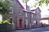
Ironville in Derbyshire
, England
, was built about 1830 by the Butterley Company
as a "model village" to house its workers. It is situated between Riddings and Codnor Park.
John Wright and William Jessop
had purchased the land adjacent to the Cromford Canal
from Lancelot Rolleston of Watnall in 1809.
The village was notable for its large gardens, and its rural setting. The Mechanics Institute was built in 1846; schools were provided in 1850 and a parish church in 1852.
The local authority demolished most of the old village in the late twentieth century.
Nearby is Pye Hill and the bend in the Cromford Canal
where it turns southward down the Erewash Valley
and the junction with its extension to Pinxton
.
About a quarter of a mile north east is another transport landmark, Pye Bridge at the junction of the Erewash Valley
railway line and the extension to Ambergate
. Part of the line to Ambergate is now preserved as Midland Railway - Butterley
, which terminates just south of the former Pye Bridge Station.
Derbyshire
Derbyshire is a county in the East Midlands of England. A substantial portion of the Peak District National Park lies within Derbyshire. The northern part of Derbyshire overlaps with the Pennines, a famous chain of hills and mountains. The county contains within its boundary of approx...
, England
England
England is a country that is part of the United Kingdom. It shares land borders with Scotland to the north and Wales to the west; the Irish Sea is to the north west, the Celtic Sea to the south west, with the North Sea to the east and the English Channel to the south separating it from continental...
, was built about 1830 by the Butterley Company
Butterley Company
Butterley Engineering was an engineering company based in Ripley, Derbyshire. The company was formed from the Butterley Company which began as Benjamin Outram and Company in 1790 and existed until 2009.-Origins:...
as a "model village" to house its workers. It is situated between Riddings and Codnor Park.
John Wright and William Jessop
William Jessop
William Jessop was an English civil engineer, best known for his work on canals, harbours and early railways in the late 18th and early 19th centuries.-Early life:...
had purchased the land adjacent to the Cromford Canal
Cromford Canal
The Cromford Canal ran 14.5 miles from Cromford to the Erewash Canal in Derbyshire, England with a branch to Pinxton. Built by William Jessop with the assistance of Benjamin Outram, its alignment included four tunnels and 14 locks....
from Lancelot Rolleston of Watnall in 1809.
The village was notable for its large gardens, and its rural setting. The Mechanics Institute was built in 1846; schools were provided in 1850 and a parish church in 1852.
The local authority demolished most of the old village in the late twentieth century.
Nearby is Pye Hill and the bend in the Cromford Canal
Cromford Canal
The Cromford Canal ran 14.5 miles from Cromford to the Erewash Canal in Derbyshire, England with a branch to Pinxton. Built by William Jessop with the assistance of Benjamin Outram, its alignment included four tunnels and 14 locks....
where it turns southward down the Erewash Valley
Erewash Valley
The Erewash Valley is the valley of the River Erewash on the border of Derbyshire and Nottinghamshire as far as the River Trent. It runs along the boundary of the southern end of the Derbyshire hills and the more rolling Nottinghamshire country...
and the junction with its extension to Pinxton
Pinxton
Pinxton is a village on the eastern boundary of Derbyshire in the Bolsover district, England.In Anglo-Saxon times it was a small agricultural community, thought to have been recorded in the Domesday Book as "Esnotrewic." It is also thought that it was known as "Snodeswic," given by Wulfric Spott to...
.
About a quarter of a mile north east is another transport landmark, Pye Bridge at the junction of the Erewash Valley
Erewash Valley
The Erewash Valley is the valley of the River Erewash on the border of Derbyshire and Nottinghamshire as far as the River Trent. It runs along the boundary of the southern end of the Derbyshire hills and the more rolling Nottinghamshire country...
railway line and the extension to Ambergate
Ambergate
Ambergate is a village in Derbyshire, England, where the River Amber joins the River Derwent.Until the early nineteenth century it was known as Toadmoor, with no more than a few artisans' cottages. The southerly half of the village was still shown as such on the Ordnance Survey's maps.It is about ...
. Part of the line to Ambergate is now preserved as Midland Railway - Butterley
Midland Railway - Butterley
The Midland Railway – Butterley is a heritage railway, formerly known until 2004 as the Midland Railway Centre, at Butterley, near Ripley in Derbyshire.-Overview:...
, which terminates just south of the former Pye Bridge Station.