

Irish Sea Glacier
Encyclopedia
Glacier
A glacier is a large persistent body of ice that forms where the accumulation of snow exceeds its ablation over many years, often centuries. At least 0.1 km² in area and 50 m thick, but often much larger, a glacier slowly deforms and flows due to stresses induced by its weight...
during the Ice Age
Ice age
An ice age or, more precisely, glacial age, is a generic geological period of long-term reduction in the temperature of the Earth's surface and atmosphere, resulting in the presence or expansion of continental ice sheets, polar ice sheets and alpine glaciers...
that, probably on more than one occasion, flowed southwards from its source areas in Scotland
Scotland
Scotland is a country that is part of the United Kingdom. Occupying the northern third of the island of Great Britain, it shares a border with England to the south and is bounded by the North Sea to the east, the Atlantic Ocean to the north and west, and the North Channel and Irish Sea to the...
and Ireland
Ireland
Ireland is an island to the northwest of continental Europe. It is the third-largest island in Europe and the twentieth-largest island on Earth...
and across the Isle of Man
Isle of Man
The Isle of Man , otherwise known simply as Mann , is a self-governing British Crown Dependency, located in the Irish Sea between the islands of Great Britain and Ireland, within the British Isles. The head of state is Queen Elizabeth II, who holds the title of Lord of Mann. The Lord of Mann is...
, Anglesey
Anglesey
Anglesey , also known by its Welsh name Ynys Môn , is an island and, as Isle of Anglesey, a county off the north west coast of Wales...
and Pembrokeshire
Pembrokeshire
Pembrokeshire is a county in the south west of Wales. It borders Carmarthenshire to the east and Ceredigion to the north east. The county town is Haverfordwest where Pembrokeshire County Council is headquartered....
.
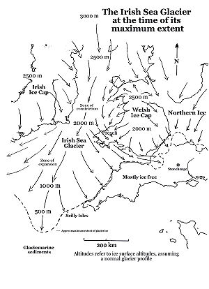
This was the only clearly defined major glacier in the Irish Sea, which flowed about 700 km from its source areas to its southernmost margin. It is sometimes referred to as an “ice stream” since it appears to have been constrained not by ice-free land areas but by highlands which were themselves buried beneath ice. At the time of its maximum extent the glacier extended all the way to the coasts of Somerset and Cornwall, along the south coast of Ireland, and even reached the Scilly Isles.
It was forced through a relatively narrow constriction in St George’s Channel by ice flowing from the Irish Ice Cap (to the west) and the Welsh Ice Cap (to the east.) At one point the glacier was probably no more than 80 km wide.
Once through this constriction, the ice spread out into a great lobe, in the area now occupied by the Celtic Sea and the approaches to the Bristol Channel. On the eastern flank of the glacier, the evidence of striations, glacial deposits and "erratic trains" shows that the edge of the Irish Sea Glacier was pushed southwards by ice coming from the Welsh ice cap on the Brecon Beacons, so that Irish Sea ice flowed parallel with the coast of South Wales and then came into contact with the English coast around the Somerset Levels, between Exmoor and the Mendips. It is not known how far inland this ice extended, but there are scattered glacial deposits in the Bridgwater - Glastonbury district -- these may mark the easternmost extent of the glacier. On its western flank the Irish Sea Glacier reached Cork Harbour. The maximum width of this great ice lobe was more than 320 km.
.jpg)
However, glaciers have to behave according to the laws of ice physics, and a long narrow lobate surge with a flat long profile would be difficult to explain. Tightly confined "valley glaciers" do not exist on open tundra situations (such as this must have been at the time)especially if the glacier bed rises southwards. Glacier ice in those circumstances must have "backed up" and spread sideways. It is most likely that when the Irish Sea Glacier reached its southernmost extent, the glacier surface must have been at c 2,000m in St George’s Channel, c 2,250m over the Isle of Anglesey, and c 2,500m over the Isle of Man. It follows that the mountains of Wales and Eastern Ireland must also have been submerged beneath thick glacier ice at the time. Furthermore, the Bristol Channel is most likely to have been ice-filled at the LGM, as indicated on the adjoining map.
New work by O'Cofaigh and Evans (2007) suggests that the area of "Older Drift" outside the South Ireland End Moraine was inundated by Irish Ice during and after the LGM. At the same time the area of Older Drift on the Welsh side of St George's Channel (outside the South Wales End Moraine) must also have been inundated by ice. But where are the glacial deposits relating to this episode of glaciation? This is one of the puzzles which researchers will need to resolve in the coming years.
Another puzzle is the extent to which the long profile of the Irish Sea Glacier, at the time of its maximum extent, approximated to the classic equilibrium profile. Work in analogous situations in Marie Byrd Land, Antarctica, by Sugden and others (2004) suggests that the ice surface altitude over the mountains might have been around 800m lower than predicted.