
Interstate 410
Encyclopedia
Interstate 410 is a loop route
of Interstate 10 around San Antonio
, Texas
. It is identified as Connally Loop in honor of former Texas governor
John Connally
. The north and west section is undergoing a major expansion from six to ten lanes (five in each direction) from Culebra Road to the I-35 interchange
as well as major interchanges being renovated at Bandera Road, I-10 and San Pedro Avenue, and an interchange recently constructed at US 281 near San Antonio International Airport
.
. Loop 13, although not a freeway, served in this role up until the 1950s, when many of San Antonio's freeways were constructed. The northern half of Loop 13 followed the current path of I-410 while the southern half still exists on the south side of San Antonio. Much of the freeway was proposed during the mid-1950s with construction beginning on the northwest portion of the loop near I-10. In 1960 Loop 13 from I-10 to I-35 was redesignated as Loop 410 for continuity purposes. By 1961 the freeway had been completed from I-35 on the southwest side to just east of US 281 near the airport where it continued on to the east as a 4-lane highway to I-35. By 1964 the southern arc had been extended eastward from I-35 to Roosevelt Avenue and was under construction from Roosevelt to I-35 on the east side of the city. By 1967 the eastern arc had been completed to Interstate Highway standards and the remaining portion from US 281 to I-35 on the cities north side had been completely upgraded to Interstate Highway standards, but still carried the State Loop 410 designation until 1969 when it officially became Interstate 410.
Due to the city growing primarily to the north, I-410 required upgrading along this stretch. It was expanded to six lanes in the late 1970s and early 1980s from Ingram Road to I-35 North. It was further expanded to six lanes from Ingram to Valley Hi Road in 1987. An additional westbound lane was added from I-10 West to Babcock Road in 1996.

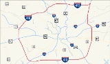
 Interstate 410 circumnavigates the city of San Antonio, officially beginning and ending at the junction with Interstate 35 on the southwest side of the loop. There are vast differences between the northern arc and southern arc of the loop. The northern arc serves the heavily urbanized portions of San Antonio and is currently being upgraded to as many as five lanes in each direction. The southern arc resembles more of a rural interstate as it transverses for the most part undeveloped portions of San Antonio as a two lane interstate. I-410 intersects I-10 twice, I-35 twice, I-37 once, as well as U.S. Highway 90, US 281, and State Highway 151, all freeways in the San Antonio metro area with the exception of 1604, which forms a secondary loop around the city. I-410 serves San Antonio International Airport
, Lackland AFB, Fort Sam Houston
, South Texas Medical Center
, Southwest Research Institute
, and Toyota Motor Manufacturing Texas
.
.
Loop route
A loop route is a highway or other major road that extends out from a typically longer, more important parents road to enter and circle a large city. A loop can function as a bypass for through traffic and also to service outlying suburbs....
of Interstate 10 around San Antonio
San Antonio, Texas
San Antonio is the seventh-largest city in the United States of America and the second-largest city within the state of Texas, with a population of 1.33 million. Located in the American Southwest and the south–central part of Texas, the city serves as the seat of Bexar County. In 2011,...
, Texas
Texas
Texas is the second largest U.S. state by both area and population, and the largest state by area in the contiguous United States.The name, based on the Caddo word "Tejas" meaning "friends" or "allies", was applied by the Spanish to the Caddo themselves and to the region of their settlement in...
. It is identified as Connally Loop in honor of former Texas governor
Governor
A governor is a governing official, usually the executive of a non-sovereign level of government, ranking under the head of state...
John Connally
John Connally
John Bowden Connally, Jr. , was an influential American politician, serving as the 39th governor of Texas, Secretary of the Navy under President John F. Kennedy, and as Secretary of the Treasury under President Richard M. Nixon. While he was Governor in 1963, Connally was a passenger in the car in...
. The north and west section is undergoing a major expansion from six to ten lanes (five in each direction) from Culebra Road to the I-35 interchange
Interchange (road)
In the field of road transport, an interchange is a road junction that typically uses grade separation, and one or more ramps, to permit traffic on at least one highway to pass through the junction without directly crossing any other traffic stream. It differs from a standard intersection, at which...
as well as major interchanges being renovated at Bandera Road, I-10 and San Pedro Avenue, and an interchange recently constructed at US 281 near San Antonio International Airport
San Antonio International Airport
San Antonio International Airport is a commercial airport in San Antonio, Texas, USA. The airport has three runways and covers . Its elevation is above sea level. SAT is a Class C airport.- Overview :...
.
History
As most cities in Texas San Antonio was served by a loop around the city long before the arrival of the Interstate Highway SystemInterstate Highway System
The Dwight D. Eisenhower National System of Interstate and Defense Highways, , is a network of limited-access roads including freeways, highways, and expressways forming part of the National Highway System of the United States of America...
. Loop 13, although not a freeway, served in this role up until the 1950s, when many of San Antonio's freeways were constructed. The northern half of Loop 13 followed the current path of I-410 while the southern half still exists on the south side of San Antonio. Much of the freeway was proposed during the mid-1950s with construction beginning on the northwest portion of the loop near I-10. In 1960 Loop 13 from I-10 to I-35 was redesignated as Loop 410 for continuity purposes. By 1961 the freeway had been completed from I-35 on the southwest side to just east of US 281 near the airport where it continued on to the east as a 4-lane highway to I-35. By 1964 the southern arc had been extended eastward from I-35 to Roosevelt Avenue and was under construction from Roosevelt to I-35 on the east side of the city. By 1967 the eastern arc had been completed to Interstate Highway standards and the remaining portion from US 281 to I-35 on the cities north side had been completely upgraded to Interstate Highway standards, but still carried the State Loop 410 designation until 1969 when it officially became Interstate 410.
Due to the city growing primarily to the north, I-410 required upgrading along this stretch. It was expanded to six lanes in the late 1970s and early 1980s from Ingram Road to I-35 North. It was further expanded to six lanes from Ingram to Valley Hi Road in 1987. An additional westbound lane was added from I-10 West to Babcock Road in 1996.
Route description
San Antonio International Airport
San Antonio International Airport is a commercial airport in San Antonio, Texas, USA. The airport has three runways and covers . Its elevation is above sea level. SAT is a Class C airport.- Overview :...
, Lackland AFB, Fort Sam Houston
Fort Sam Houston
Fort Sam Houston is a U.S. Army post in San Antonio, Texas.Known colloquially as "Fort Sam," it is named for the first President of the Republic of Texas, Sam Houston....
, South Texas Medical Center
South Texas Medical Center
The South Texas Medical Center consists of of medical-related facilities in northwest San Antonio.The STMC, which directly serves 38 counties, consists of forty-five medically related institutions; separate medical, dental and nursing schools, five higher educational institutions, twelve...
, Southwest Research Institute
Southwest Research Institute
Southwest Research Institute , headquartered in San Antonio, Texas, is one of the oldest and largest independent, nonprofit, applied research and development organizations in the United States...
, and Toyota Motor Manufacturing Texas
Toyota Motor Manufacturing Texas
Toyota Motor Manufacturing Texas, Inc is an automobile production subsidiary of Toyota Motor Corporation based in San Antonio, Texas, USA which owns and operates a manufacturing and assembly facility for the parent company...
.
Future
410 is being widened along its entire northern arc from Culebra road to Austin Highway, with five lanes each way and intersection upgrades at I-10 and San Pedro, and an entire new interchange at US 281, officially called the "San Antonio Web".Exit list
The entire route is in Bexar County, and forms a complete loop. Exit numbers correspond to mileage from the south junction with I-35Interstate 35 in Texas
Interstate 35 in Texas is a major north–south Interstate Highway running from Laredo near the United States-Mexico border to the Red River north of Gainesville where it crosses into Oklahoma. Along its route, it passes through the cities of San Antonio, Austin, and Waco before it splits into two...
.
| Location | # Exit number An exit number is a number assigned to a road junction, usually an exit from a freeway. It is usually marked on the same sign as the destinations of the exit, as well as a sign in the gore.... |
Destinations | Notes |
|---|---|---|---|
| San Antonio | 1 | Frontage Road | |
| 2 | |||
| 3A | Ray Ellison Drive | Signed as exit 3 northbound | |
| 3B | Medina Base Road | Northbound exit is via exit 3 | |
| 4 | Valley Hi Drive – Lackland AFB | ||
| 6 | |||
| 7 | Marbach Road | ||
| 8 | Lakeside Parkway | Southbound exit and entrance | |
| 9A | – SeaWorld SeaWorld San Antonio SeaWorld San Antonio is a marine mammal park, oceanarium, and animal theme park, located in the Westover Hills area of San Antonio, Texas. It is the largest of the three parks in the SeaWorld chain owned by SeaWorld Parks & Entertainment, a division of The Blackstone Group, and the world's... |
Signed as exit 9 northbound | |
| 9B | W Military Drive | Southbound exit and northbound entrance | |
| 10 | |||
| 11 | Ingram Road | ||
| 12 | Exchange Parkway | Southbound exit and entrance | |
| 13A | North end of SH 16 concurrency | ||
| 13B | Evers Road | Westbound exit and eastbound entrance | |
| 14A | Summit Parkway | Westbound exit and entrance | |
| 14B | Callaghan Road | Signed as exit 14 eastbound | |
| 14C | Babcock Road | Eastbound exit is via exit 14 | |
| 15 | |||
| 16 | |||
| 17 | Vance Jackson Road, Cherry Ridge Drive | Signed as exit 17B eastbound | |
| Castle Hills Castle Hills, Texas Castle Hills is a city located in Bexar County, Texas, United States. As of the 2000 census, the city had a total population of 4,202. It is an enclave of San Antonio and is part of the San Antonio Metropolitan Statistical Area.-Geography:... |
18 | Jackson-Keller Road, West Avenue | |
| 19A | Honeysuckle Lane | Eastbound exit is via exit 18 | |
| 19B | Signed as exit 19 eastbound | ||
| 19 | Westbound exit is via exit 20A | ||
| San Antonio | 20A | Signed as exit 20 eastbound | |
| 20B | McCullough Avenue | Eastbound exit is via exit 20 | |
| 21A | , Downtown Downtown San Antonio Downtown San Antonio is the central business district of San Antonio, Texas, United States.Downtown is encircled by three numerical freeways, I-35, I-37, and I-10... |
"San Antonio Web", fully opened June 9, 2008 | |
| 21 | Airport Boulevard, Wetmore Road – Int'l Airport San Antonio International Airport San Antonio International Airport is a commercial airport in San Antonio, Texas, USA. The airport has three runways and covers . Its elevation is above sea level. SAT is a Class C airport.- Overview :... |
Signed as exit 21B eastbound | |
| 22 | Broadway | ||
| 23 | Nacogdoches Road | ||
| 24 | Harry Wurzbach Road – Fort Sam Houston Fort Sam Houston Fort Sam Houston is a U.S. Army post in San Antonio, Texas.Known colloquially as "Fort Sam," it is named for the first President of the Republic of Texas, Sam Houston.... |
||
| 25A | Starcrest Drive | ||
| 25B | |||
| 26A | Signed as exit 26 westbound | ||
| 26B | Interchange Parkway, Perrin Creek Drive | Eastbound exit and westbound entrance | |
| North end of I-35 concurrency | |||
| Randolph Boulevard – Windcrest Windcrest, Texas Windcrest is a city in Bexar County, Texas, United States. The population was 5,105 at the 2000 census. It is part of the San Antonio Metropolitan Statistical Area.-Geography:Windcrest is located at .... |
|||
| 165 | |||
| 164B | Eisenhauer Road | ||
| 164A | Rittiman Road | ||
| South end of I-35 concurrency | |||
| – Downtown Downtown San Antonio Downtown San Antonio is the central business district of San Antonio, Texas, United States.Downtown is encircled by three numerical freeways, I-35, I-37, and I-10... |
Southbound exit and northbound entrance | ||
| 30 | Space Center Drive | Northbound exit and entrance | |
| 30 | Binz-Engleman Road | Southbound exit and northbound entrance | |
| 31A | Signed as exit 32 northbound | ||
| 31 | Northbound left exit and southbound entrance | ||
| 31B | No northbound exit | ||
| 32 | Dietrich Road | Southbound exit only | |
| 33 | – San Antonio, Houston | ||
| 34 | |||
| 35 | |||
| 37 | Southcross Boulevard/New Sulpher Springs Road, Sinclair Road | ||
| 39 | |||
| 41 | East end of US 281 concurrency | ||
| 42 | |||
| 43 | Espada Road – San Antonio Missions National Historical Park San Antonio Missions National Historical Park San Antonio Missions National Historical Park preserves four of the five Spanish frontier missions in San Antonio, Texas. These outposts were established by Catholic religious orders to spread Christianity among the local natives... |
Westbound exit is via exit 44 | |
| 44 | West end of US 281 concurrency | ||
| 46 | Moursund Boulevard | ||
| 48 | Zarzamora Street | ||
| 49 | East end of SH 16 concurrency | ||
| 51 | |||
| 53 | |||