
Ingleton Waterfalls Trail
Encyclopedia
Ingleton Waterfalls Trail is a well-known circular trail
beginning and ending in the village of Ingleton
in the English county
of North Yorkshire
, now maintained by the Ingleton Scenery Company. It is claimed that the trail, some 8 kilometres (5 mi) long, and with a vertical rise of 169 m (554 feet) has some of the most spectacular waterfall
and woodland
scenery in the north of England
.
, 11 April 1885.
, through Swilla Glenn with its coin embedded tree and on to Pecca Falls, Pecca Twin Falls, Holly Bush Spout and Thornton Force. A footbridge bridge crosses the Twiss and leads on to Twistleton Lane, where in summer there is often an Ice Cream Van waiting to serve hot and thirsty tourists. Following Twistleton Lane down past Scar End
Farm and Twistleton Hall the walk crosses Oddies Lane to Beezley's Farm.
Past Beezley’s the trail starts its descent along the banks of the River Doe
. This river emerges near God's Bridge close to the settlement of Chapel-le-Dale
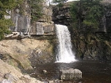
and flows gently until it reaches the waterfalls walk at Beezley's Falls Triple Spout (with its three waterfalls side-by side). As the trail continues, you look down 18 metres (59 feet) onto Rival Falls and then onto Baxenghyl Gorge, Snow Falls and finally walk through Twistleton Glenn and back to Ingleton.
In Ingleton, the Twiss and the Doe meet to form the River Greta
, which in turn flows into the River Lune
.
English Nature
designated the River Twiss and River Doe areas of the Waterfalls Trail as a Site of Special Scientific Interest
(SSSI) due to the interesting plants and animals and the geological structures located there.
Trail
A trail is a path with a rough beaten or dirt/stone surface used for travel. Trails may be for use only by walkers and in some places are the main access route to remote settlements...
beginning and ending in the village of Ingleton
Ingleton, North Yorkshire
Ingleton is a village and civil parish in the Yorkshire Dales in North Yorkshire, England. It is famous for walking, hiking and caving. Favourite walks are the Ingleton Waterfalls Trail and the climb up Ingleborough which is one of the famous Three Peaks. Directly from the village visitors can...
in the English county
County
A county is a jurisdiction of local government in certain modern nations. Historically in mainland Europe, the original French term, comté, and its equivalents in other languages denoted a jurisdiction under the sovereignty of a count A county is a jurisdiction of local government in certain...
of North Yorkshire
North Yorkshire
North Yorkshire is a non-metropolitan or shire county located in the Yorkshire and the Humber region of England, and a ceremonial county primarily in that region but partly in North East England. Created in 1974 by the Local Government Act 1972 it covers an area of , making it the largest...
, now maintained by the Ingleton Scenery Company. It is claimed that the trail, some 8 kilometres (5 mi) long, and with a vertical rise of 169 m (554 feet) has some of the most spectacular waterfall
Waterfall
A waterfall is a place where flowing water rapidly drops in elevation as it flows over a steep region or a cliff.-Formation:Waterfalls are commonly formed when a river is young. At these times the channel is often narrow and deep. When the river courses over resistant bedrock, erosion happens...
and woodland
Woodland
Ecologically, a woodland is a low-density forest forming open habitats with plenty of sunlight and limited shade. Woodlands may support an understory of shrubs and herbaceous plants including grasses. Woodland may form a transition to shrubland under drier conditions or during early stages of...
scenery in the north of England
England
England is a country that is part of the United Kingdom. It shares land borders with Scotland to the north and Wales to the west; the Irish Sea is to the north west, the Celtic Sea to the south west, with the North Sea to the east and the English Channel to the south separating it from continental...
.
Beginnings
Following a number of articles in the Lancaster Guardian and other newspapers about the scenery in and around Ingleton, public interest led to the creation of the trail in an area which was previously hidden from view. Paths and bridges were built and the trail opened on Good FridayGood Friday
Good Friday , is a religious holiday observed primarily by Christians commemorating the crucifixion of Jesus Christ and his death at Calvary. The holiday is observed during Holy Week as part of the Paschal Triduum on the Friday preceding Easter Sunday, and may coincide with the Jewish observance of...
, 11 April 1885.
The Walk
Starting in the Broadwood car park the trail takes walkers along the banks of the River TwissRiver Twiss
The River Twiss is a river in the county of Yorkshire, England. The source of the river is Kingsdale Beck which rises at Kingsdale Head at the confluence of Back Gill and Long Gill in the Yorkshire Dales. Beneath Keld Head, it changes its name to the River Twiss...
, through Swilla Glenn with its coin embedded tree and on to Pecca Falls, Pecca Twin Falls, Holly Bush Spout and Thornton Force. A footbridge bridge crosses the Twiss and leads on to Twistleton Lane, where in summer there is often an Ice Cream Van waiting to serve hot and thirsty tourists. Following Twistleton Lane down past Scar End
Scar End
Scar End is a settlement on the side of Twistleton Scar in the English county of North Yorkshire.This Scar itself is the end of a spur running westwards from Whernside, one of the Three Peaks, towards Ingleton, North Yorkshire. Looking out towards the west from Twistleton Scar is Ingleton and to...
Farm and Twistleton Hall the walk crosses Oddies Lane to Beezley's Farm.
Past Beezley’s the trail starts its descent along the banks of the River Doe
River Doe
The River Doe is a river in North Yorkshire, England.The river emerges near God's Bridge close to the settlement of Chapel-le-Dale and flows through Twisleton in a southwesterly direction to Ingleton, where it meets the River Twiss to form the River Greta. The river forms part of the River Lune...
. This river emerges near God's Bridge close to the settlement of Chapel-le-Dale
Chapel-le-Dale
Chapel-le-Dale is a hamlet in the Yorkshire Dales, England, very near Ribblehead Viaduct. The hamlet is in close proximity to Ingleborough and several potholes, the best known being Great Douk Cave. The source of the River Doe is nearby.-External links:*...
and flows gently until it reaches the waterfalls walk at Beezley's Falls Triple Spout (with its three waterfalls side-by side). As the trail continues, you look down 18 metres (59 feet) onto Rival Falls and then onto Baxenghyl Gorge, Snow Falls and finally walk through Twistleton Glenn and back to Ingleton.
In Ingleton, the Twiss and the Doe meet to form the River Greta
River Greta (Lune)
The River Greta is a river flowing through Lancashire and North Yorkshire in the north of England.The river is formed by the confluence of the River Twiss and the River Doe at Ingleton....
, which in turn flows into the River Lune
River Lune
The River Lune is a river in Cumbria and Lancashire, England.It is formed at Wath, in the parish of Ravenstonedale, Cumbria, at the confluence of Sandwath Beck and Weasdale Beck...
.
English Nature
English Nature
English Nature was the United Kingdom government agency that promoted the conservation of wildlife, geology and wild places throughout England between 1990 and 2006...
designated the River Twiss and River Doe areas of the Waterfalls Trail as a Site of Special Scientific Interest
Site of Special Scientific Interest
A Site of Special Scientific Interest is a conservation designation denoting a protected area in the United Kingdom. SSSIs are the basic building block of site-based nature conservation legislation and most other legal nature/geological conservation designations in Great Britain are based upon...
(SSSI) due to the interesting plants and animals and the geological structures located there.