
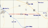
Indiana State Road 244
Encyclopedia
State Road 244 in the U.S. state
of Indiana
is a 22-mile east–west route southeast of Indianapolis.
at Exit 119 in Shelby County
. It passes over I-74 with an interchange, then proceeds east through the town of Milroy
, where it intersects State Road 3
. It continues east until it meets U.S. Route 52
in Franklin County
at the small town of Andersonville.
U.S. state
A U.S. state is any one of the 50 federated states of the United States of America that share sovereignty with the federal government. Because of this shared sovereignty, an American is a citizen both of the federal entity and of his or her state of domicile. Four states use the official title of...
of Indiana
Indiana
Indiana is a US state, admitted to the United States as the 19th on December 11, 1816. It is located in the Midwestern United States and Great Lakes Region. With 6,483,802 residents, the state is ranked 15th in population and 16th in population density. Indiana is ranked 38th in land area and is...
is a 22-mile east–west route southeast of Indianapolis.
Route description
State Road 244 begins just west of Interstate 74Interstate 74
Interstate 74 is an Interstate Highway in the Midwestern and Southeastern United States. Its western end is at an intersection with Interstate 80 in Davenport, Iowa; the eastern end of its Midwest segment is at an intersection with Interstate 75 in Cincinnati, Ohio...
at Exit 119 in Shelby County
Shelby County, Indiana
As of the census of 2000, there were 43,445 people, 16,561 households, and 12,056 families residing in the county. The population density was 105 people per square mile . There were 17,633 housing units at an average density of 43 per square mile...
. It passes over I-74 with an interchange, then proceeds east through the town of Milroy
Milroy, Indiana
Milroy is located in Anderson Township, in the southern part of Rush County, Indiana. It is the location of Milroy Elementary School, a school in the Rush County Schools Corporation. It had a population of 604 at the 2010 census....
, where it intersects State Road 3
Indiana State Road 3
State Road 3 in the U.S. State of Indiana is a discontinuous state road running through east central Indiana from near the Michigan state line to near the Ohio River...
. It continues east until it meets U.S. Route 52
U.S. Route 52
U.S. Route 52 is a United States highway that runs across the northern, eastern and southeastern regions of the United States. Contrary to most other even-numbered U.S...
in Franklin County
Franklin County, Indiana
As of the census of 2000, there were 22,151 people, 7,868 households, and 6,129 families residing in the county. The population density was 57 people per square mile . There were 8,596 housing units at an average density of 22 per square mile...
at the small town of Andersonville.