
Imakane, Hokkaido
Encyclopedia
is a town
located in Setana District
, Hiyama
, Hokkaidō
, Japan
.
As of 2008, the town has an estimated population
of 6,258 and a density
of 11.53 persons per km². The total area is 568.14 km².
, Hiyama Subprefecture
. The town is on Route 230 at the junction of the Shiribeshi-Toshibetsu and Toshibetsu-Mena rivers. The main landmark and meeting point in the town center is De Molen, a large windmill.
Neighboring towns
Mountains 981 m
Rivers
Dams
, a Shinto
shrine in Tochigi Prefecture
dedicated to Tokugawa Ieyasu
.
Agate was found in Hanaishi in 1877. Mining was started by Oshima Kanzaemon. Meanwhile increasing numbers of people arrived in the area to mine existing seams of manganese, gold and silver and by the middle of the Meji era many had settled in the Shiribetsu river area.
The town was granted independent status as the village of Toshibetsu and formed from the neighboring town of Setana in 1897. It was settled by Norioshi Shikata and 15 other families, including the Imamura and Kanamori houses. These families had arrived in the area during the preceding five years and laid out the town into 129 housing sites, a city hall and a police station.
Toshibetsu village formally received the name of Imakane in 1947 as part of its upgrade to town status. The name was taken from the family names of its two celebrated pioneers, and .
The town's constitution was established on October 1, 1967. Imakane celebrated its 100th year of autonomous government on July 15, 1997.
The name of the church is; Immanuel which means "God with us" in Hebrew. However, during the war years foreign words were strictly controlled by the government so they changed the name to and the surrounding area to 神丘, meaning "God’s land" to preserve their religion. It was in this area around the church that Ginko Ogino, the first woman doctor in Japan, grew up. She was also the heroine in the novel “Hana-uzumi” written by one of the famous Japanese writers, Jun’ichi Watanabe. He came to Hokkaidō and settled in this area and married Yoshiyuki Shikata.
, and iwana can be found in the area.
Another symbol of Imakane is a large windmill located in the center of town where the old train station stood. It is called "De Moren Imakane". The Name "De Moren" is Dutch for "windmill". In Spring the tulips come into flower and is one of the symbols for Imakane.
Imakane Junior High School has an exchange program with Burnside High School, Christchurch
, New Zealand
. Burnside High School students studying Japanese last visited Imakane in July 2010. 5 Imakane students visited Burnside High School in 2010.
2008 marked the 20th anniversary of the link and the present Burnside vice-Principal Mrs Hume visited Imakane along with a number of students. Special events were held to mark the occasion.
Towns of Japan
A town is a local administrative unit in Japan. It is a local public body along with prefecture , city , and village...
located in Setana District
Setana District, Hokkaido
is a district located in Hiyama Subprefecture, Hokkaidō, Japan.As of 2004, the district has an estimated population of 15,173 and a density of 14.14 persons per km². The total area is 1,072.86 km².-Towns and villages:*Imakane...
, Hiyama
Hiyama Subprefecture
is a subprefecture of Hokkaidō, Japan located on the Oshima Peninsula on the Sea of Japan side. It includes Okushiri Island. It was established in 1897.-Towns and villages by district:* Hiyama District** Assabu** Esashi ** Kaminokuni* Kudō District...
, Hokkaidō
Hokkaido
, formerly known as Ezo, Yezo, Yeso, or Yesso, is Japan's second largest island; it is also the largest and northernmost of Japan's 47 prefectural-level subdivisions. The Tsugaru Strait separates Hokkaido from Honshu, although the two islands are connected by the underwater railway Seikan Tunnel...
, Japan
Japan
Japan is an island nation in East Asia. Located in the Pacific Ocean, it lies to the east of the Sea of Japan, China, North Korea, South Korea and Russia, stretching from the Sea of Okhotsk in the north to the East China Sea and Taiwan in the south...
.
As of 2008, the town has an estimated population
Population
A population is all the organisms that both belong to the same group or species and live in the same geographical area. The area that is used to define a sexual population is such that inter-breeding is possible between any pair within the area and more probable than cross-breeding with individuals...
of 6,258 and a density
Population density
Population density is a measurement of population per unit area or unit volume. It is frequently applied to living organisms, and particularly to humans...
of 11.53 persons per km². The total area is 568.14 km².
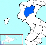
Geography
Imakane is located in southern Hokkaidō within Setana DistrictSetana District, Hokkaido
is a district located in Hiyama Subprefecture, Hokkaidō, Japan.As of 2004, the district has an estimated population of 15,173 and a density of 14.14 persons per km². The total area is 1,072.86 km².-Towns and villages:*Imakane...
, Hiyama Subprefecture
Hiyama Subprefecture
is a subprefecture of Hokkaidō, Japan located on the Oshima Peninsula on the Sea of Japan side. It includes Okushiri Island. It was established in 1897.-Towns and villages by district:* Hiyama District** Assabu** Esashi ** Kaminokuni* Kudō District...
. The town is on Route 230 at the junction of the Shiribeshi-Toshibetsu and Toshibetsu-Mena rivers. The main landmark and meeting point in the town center is De Molen, a large windmill.
Neighboring towns
- OshamanbeOshamanbe, Hokkaidois a town located in Yamakoshi District, Oshima, Hokkaido, Japan.As of 31 October 2011, the town has an estimated population of 6,300 with 3,280 households. The total area is 310.75 km².-External links:...
to the east - SetanaSetana, Hokkaidois a town located in Kudō District, Hiyama, Hokkaidō, Japan.As of December 2008, the town has an estimated population of 10,190 and a density of 15.96 persons per km²...
to the west - YakumoYakumo, Hokkaidois a town located in Futami District, Oshima, Hokkaidō, Japan.As of 2008, the town has an estimated population of 19,543 and a density of 23.08 persons per km². The total area is 955.98 km²....
to the south east
Mountains 981 m
Rivers
- Shiribeshi-Toshibetsu RiverShiribeshi-Toshibetsu Riveris a river in Hokkaidō, Japan....
- Toshibetsu-Mena River
Dams
- Pirika DamPirika DamThe is a dam located in Imakane, Setana District, Hiyama, Hokkaidō, Japan.The dam is longest dam in Japan and the biggest in southern Hokkaidō at 80 meters in length. It is known for hosting the longest fish race in Japan .-External links:*...
History
Imakane, at the time known as Hanaishi, was founded in the Kan'ei period between 1624 to 1643 after gold, silver and manganese were discovered in the upper Shiribetsu River, near Pirika/Hanaishi. Some of the gold mined from the area was used to build Nikkō Tōshō-gūNikko Tosho-gu
is a Shinto shrine located in Nikkō, Tochigi Prefecture, Japan. It is part of the "Shrines and Temples of Nikkō", a UNESCO World Heritage Site.Tōshō-gū is dedicated to Tokugawa Ieyasu, the founder of the Tokugawa shogunate. Initially built in 1617, during the Edo period, while Ieyasu's son Hidetada...
, a Shinto
Shinto
or Shintoism, also kami-no-michi, is the indigenous spirituality of Japan and the Japanese people. It is a set of practices, to be carried out diligently, to establish a connection between present day Japan and its ancient past. Shinto practices were first recorded and codified in the written...
shrine in Tochigi Prefecture
Tochigi Prefecture
is a prefecture located in the Kantō region on the island of Honshū, Japan. The capital is the city of Utsunomiya.Nikkō, whose ancient Shintō shrines and Buddhist temples UNESCO has recognized by naming them a World Heritage Site, is in this prefecture...
dedicated to Tokugawa Ieyasu
Tokugawa Ieyasu
was the founder and first shogun of the Tokugawa shogunate of Japan , which ruled from the Battle of Sekigahara in 1600 until the Meiji Restoration in 1868. Ieyasu seized power in 1600, received appointment as shogun in 1603, abdicated from office in 1605, but...
.
Agate was found in Hanaishi in 1877. Mining was started by Oshima Kanzaemon. Meanwhile increasing numbers of people arrived in the area to mine existing seams of manganese, gold and silver and by the middle of the Meji era many had settled in the Shiribetsu river area.
The town was granted independent status as the village of Toshibetsu and formed from the neighboring town of Setana in 1897. It was settled by Norioshi Shikata and 15 other families, including the Imamura and Kanamori houses. These families had arrived in the area during the preceding five years and laid out the town into 129 housing sites, a city hall and a police station.
Toshibetsu village formally received the name of Imakane in 1947 as part of its upgrade to town status. The name was taken from the family names of its two celebrated pioneers, and .
The town's constitution was established on October 1, 1967. Imakane celebrated its 100th year of autonomous government on July 15, 1997.
The Immanuel Church and the History of Imakane
One of the attractions in rural Imakane is a very old church. In May 1881 Yoshiyuki Shikata and 10 other devout Christian students of the Doshisha University in Kyoto, settled in Imakane. They built a straw thatched church in March 1896 as their spiritual base and they worked hard on the land while leading a frugal religious life. In 1918 the church was rebuilt with wooden walls and again in November 1968 to its present day state.The name of the church is; Immanuel which means "God with us" in Hebrew. However, during the war years foreign words were strictly controlled by the government so they changed the name to and the surrounding area to 神丘, meaning "God’s land" to preserve their religion. It was in this area around the church that Ginko Ogino, the first woman doctor in Japan, grew up. She was also the heroine in the novel “Hana-uzumi” written by one of the famous Japanese writers, Jun’ichi Watanabe. He came to Hokkaidō and settled in this area and married Yoshiyuki Shikata.
Industry
Today Imakane's main industry is farming. Imakane is famous nationwide for potatoes, especially the Danshaku variety. Fishing is also widespread; yamame, ayu, unagiUnagi
Unagi is the Japanese word for freshwater eels, especially the Japanese eel, Anguilla japonica. Saltwater eels are known as anago in Japanese. Unagi are a common ingredient in Japanese cooking...
, and iwana can be found in the area.
Culture
Imakane has a number of festivals, including the Snow festival in mid February (usually the weekend after Sapporo's) and the Autumn Festival on September 19 and 20 every year.Symbol of the Town
The symbol of Imakane comprises the meandering Toshibetsu River and the 1st letter of 農耕 (farming) which can be written in katakana as ノ and pronounced "no". This symbol was decided upon by a public competition on the town’s 70th anniversary (1967)Another symbol of Imakane is a large windmill located in the center of town where the old train station stood. It is called "De Moren Imakane". The Name "De Moren" is Dutch for "windmill". In Spring the tulips come into flower and is one of the symbols for Imakane.
Schools
Due to the steadily decreasing population, a result a number of schools have closed in recent years, including Yatsuka, Kinbara, Hanaishi and Kamioka elementary schools.Imakane Junior High School has an exchange program with Burnside High School, Christchurch
Christchurch
Christchurch is the largest city in the South Island of New Zealand, and the country's second-largest urban area after Auckland. It lies one third of the way down the South Island's east coast, just north of Banks Peninsula which itself, since 2006, lies within the formal limits of...
, New Zealand
New Zealand
New Zealand is an island country in the south-western Pacific Ocean comprising two main landmasses and numerous smaller islands. The country is situated some east of Australia across the Tasman Sea, and roughly south of the Pacific island nations of New Caledonia, Fiji, and Tonga...
. Burnside High School students studying Japanese last visited Imakane in July 2010. 5 Imakane students visited Burnside High School in 2010.
2008 marked the 20th anniversary of the link and the present Burnside vice-Principal Mrs Hume visited Imakane along with a number of students. Special events were held to mark the occasion.
External links
- Town website in Japanese