
Ilford Road Metro station
Encyclopedia
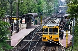
Ilford Road Metro station is located mid-way between the Newcastle upon Tyne
suburbs of Jesmond
and Gosforth
. The station opened in August 1980 and is served by the Tyne and Wear Metro
service. It was the "typical Metro halt" used in publicity when the system first opened; when other stations were being repainted red, green or blue in the early years of the 21st century, Ilford Road was repainted in original brown, with much of the unpainted concrete being painted cream.
The station is unique on the Metro system in that it does not provide any means for passengers to cross from one platform to the other (such as a footbridge
, level crossing
, or pedestrian subway
). Passengers must instead use the nearby road bridge to cross the line (a distance of approximately 350m).
The station platforms at Ilford Road cross the 55th parallel north
line of latitude
.
Newcastle upon Tyne
Newcastle upon Tyne is a city and metropolitan borough of Tyne and Wear, in North East England. Historically a part of Northumberland, it is situated on the north bank of the River Tyne...
suburbs of Jesmond
Jesmond
Jesmond is a residential suburb and is split into two electoral wards just north of the centre of Newcastle upon Tyne, England. The population is about 12,000. It is adjacent to, and to the east of, the Town Moor, providing pedestrian and cycle paths to Spital Tongues and the city's two Universities...
and Gosforth
Gosforth
Gosforth is an area of Newcastle upon Tyne, Tyne and Wear, England, United Kingdom, to the north of the city centre. Gosforth constituted an urban district from 1895 to 1974, when it became part of the City of Newcastle upon Tyne. It has a population of 23,620...
. The station opened in August 1980 and is served by the Tyne and Wear Metro
Tyne and Wear Metro
The Tyne and Wear Metro, also known as the Metro, is a light rail system in North East England, serving Newcastle upon Tyne, Gateshead, South Tyneside, North Tyneside and Sunderland. It opened in 1980 and in 2007–2008 provided 40 million public journeys on its network of nearly...
service. It was the "typical Metro halt" used in publicity when the system first opened; when other stations were being repainted red, green or blue in the early years of the 21st century, Ilford Road was repainted in original brown, with much of the unpainted concrete being painted cream.
The station is unique on the Metro system in that it does not provide any means for passengers to cross from one platform to the other (such as a footbridge
Footbridge
A footbridge or pedestrian bridge is a bridge designed for pedestrians and in some cases cyclists, animal traffic and horse riders, rather than vehicular traffic. Footbridges complement the landscape and can be used decoratively to visually link two distinct areas or to signal a transaction...
, level crossing
Level crossing
A level crossing occurs where a railway line is intersected by a road or path onone level, without recourse to a bridge or tunnel. It is a type of at-grade intersection. The term also applies when a light rail line with separate right-of-way or reserved track crosses a road in the same fashion...
, or pedestrian subway
Subway (underpass)
In England and Wales, the Republic of Ireland, Hong Kong and some Commonwealth countries , the term subway normally refers to a specially constructed underpass for pedestrians and/or cyclists beneath a road or railway, allowing them to reach the other side in safety.The term is also used in the...
). Passengers must instead use the nearby road bridge to cross the line (a distance of approximately 350m).
The station platforms at Ilford Road cross the 55th parallel north
55th parallel north
The 55th parallel north is a circle of latitude that is 55 degrees north of the Earth's equatorial plane. It crosses Europe, Asia, the Pacific Ocean, North America, and the Atlantic Ocean....
line of latitude
Latitude
In geography, the latitude of a location on the Earth is the angular distance of that location south or north of the Equator. The latitude is an angle, and is usually measured in degrees . The equator has a latitude of 0°, the North pole has a latitude of 90° north , and the South pole has a...
.
External links
- Train times and station information for from NexusTyne and Wear Passenger Transport ExecutiveThe Tyne and Wear Passenger Transport Executive using the brandname of Nexus, is the Passenger Transport Executive for the Tyne and Wear region of North East England....