
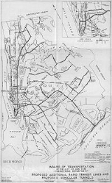
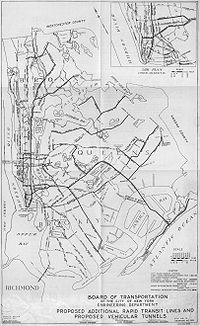
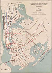
IND Second System
Encyclopedia
New York City Subway
The New York City Subway is a rapid transit system owned by the City of New York and leased to the New York City Transit Authority, a subsidiary agency of the Metropolitan Transportation Authority and also known as MTA New York City Transit...
system. The first one, conceived in 1929, was to be part of the city-operated Independent Subway System
Independent Subway System
The Independent Subway System , formerly known as the Independent City-Owned Subway System or the Independent City-Owned Rapid Transit Railroad, was a rapid transit rail system in New York City that is now part of the New York City Subway...
(IND). By 1939, with unification planned, all three systems were included. Very few of these far-reaching lines were built, though provisions were made for future expansion on lines that intersect the proposals. The core Manhattan lines of the expansion were the Second Avenue Line (with an extension into the Bronx
The Bronx
The Bronx is the northernmost of the five boroughs of New York City. It is also known as Bronx County, the last of the 62 counties of New York State to be incorporated...
) and the Worth Street Line (connecting to the Rockaways). The Rockaways were eventually served by the subway via a city takeover of the Long Island Rail Road
Long Island Rail Road
The Long Island Rail Road or LIRR is a commuter rail system serving the length of Long Island, New York. It is the busiest commuter railroad in North America, serving about 81.5 million passengers each year. Established in 1834 and having operated continuously since then, it is the oldest US...
's Rockaway Beach Branch
Rockaway Beach Branch
The Rockaway Beach Branch was a rail line owned and operated by the Long Island Rail Road in Queens, New York City, United States. The line left the Main Line at Whitepot Junction in Rego Park heading south via Ozone Park and across Jamaica Bay to Hammels in the Rockaways turning west there to a...
, which was also in the 1939 plans; the Second Avenue Subway
Second Avenue Subway
The Second Avenue Subway is a planned rapid transit subway line, part of the New York City Subway system. Phase I, consisting of two miles of tunnel and three stations, is currently under construction underneath Second Avenue in the borough of Manhattan.A plan for more than 75 years, the Second...
is under construction as of 2011. It is of note that the majority of lines were designated to be built as elevated lines; this was likely a cost-cutting measure. The majority of the expansion was to occur in Queens, with the original proposal suggesting 52 miles of track be built in Queens alone.
Provisions
The following provisions were made for connections and transfers to the new lines:- At Second Avenue on the IND Sixth Avenue LineIND Sixth Avenue LineThe Sixth Avenue Line is a rapid transit line of the B Division of the New York City Subway in the United States. It runs mainly under Sixth Avenue in Manhattan, and continues south through the Rutgers Street Tunnel to Brooklyn...
, a large open space was built above for the four-track IND Second Avenue Line. - At East BroadwayEast Broadway (IND Sixth Avenue Line)East Broadway is a station on the IND Sixth Avenue Line of the New York City Subway. It is served by the F train at all times.There is an abandoned tower at the north end of the island platform. The station has two mezzanines, four open staircases, three closed staircases, and one escalator...
on the IND Sixth Avenue Line (under Rutgers Street here), part of a two-track station was built for the line under East Broadway, above the existing line. This is now part of the mezzanineMezzanine (architecture)In architecture, a mezzanine or entresol is an intermediate floor between main floors of a building, and therefore typically not counted among the overall floors of a building. Often, a mezzanine is low-ceilinged and projects in the form of a balcony. The term is also used for the lowest balcony in...
. - At BroadwayBroadway (IND Crosstown Line)Broadway is a station on the IND Crosstown Line of the New York City Subway. Located at the intersection of Broadway and Union Avenue in Williamsburg, Brooklyn, it is served at all times by the G train.- Description :...
on the IND Crosstown LineIND Crosstown Line-External links:*...
, traces of stairways are visible going up to a six-track station on the line to the Rockaways. - At Utica AvenueUtica Avenue (IND Fulton Street Line)Utica Avenue is an express station on the IND Fulton Street Line of the New York City Subway. The tile color is maroon with a tuscan red border. The station has been renovated with new old-fashioned light fixtures with modern sodium-vapor lamps in them. They are suspended on long rods from the...
on the IND Fulton Street LineIND Fulton Street LineThe IND Fulton Street Line is a rapid transit line of the IND Division of the New York City Subway, extending from the Cranberry Street Tunnel under the East River through all of central Brooklyn to a terminus in Ozone Park, Queens. The IND Rockaway Line branches from it. It forms part of the A...
, a four-track station above can be seen in the ceiling of the existing station. The existing mezzanine passes over the unused space. - At Roosevelt Avenue on the IND Queens Boulevard LineIND Queens Boulevard LineThe Queens Boulevard Line is a fully underground line of the B Division of the New York City Subway in Manhattan and Queens, New York City, United States. The line provides crosstown service across Manhattan under 53rd Street and east through Queens to Jamaica...
, a two-track upper level was built for the Winfield Spur towards the line to the Rockaways. Unlike the other stations, this one was completed, except for track. - A junction was built on the IND Queens Boulevard Line for the line under Van Wyck Boulevard; it has since been connected to the IND Archer Avenue Line.
- The express tracks on the IND Sixth Avenue Line end at the curve into Essex Street; these were planned to continue towards the Rockaways.
- A line to the Rockaways would have split from the IND Eighth Avenue LineIND Eighth Avenue LineThe Eighth Avenue Line is a rapid transit line in New York City, United States, and is part of the B Division of the New York City Subway...
(under Church Street here), east under Worth Street. The junction was built and is used by the local tracks to World Trade Center. - The tracks that the IND 63rd Street LineIND 63rd Street LineThe IND 63rd Street Line is a rapid transit line of the IND division of the New York City Subway system. It runs from the IND Sixth Avenue Line at 57th Street east under 63rd Street and the East River through the 63rd Street Tunnel to the IND Queens Boulevard Line in Queens...
uses to split from the IND Sixth Avenue Line were built for a similar proposed line (under 61st Street). - The completed IND 63rd Street LineIND 63rd Street LineThe IND 63rd Street Line is a rapid transit line of the IND division of the New York City Subway system. It runs from the IND Sixth Avenue Line at 57th Street east under 63rd Street and the East River through the 63rd Street Tunnel to the IND Queens Boulevard Line in Queens...
, which the train uses to cross the East RiverEast RiverThe East River is a tidal strait in New York City. It connects Upper New York Bay on its south end to Long Island Sound on its north end. It separates Long Island from the island of Manhattan and the Bronx on the North American mainland...
, was designed and built with bell mouths to allow for the construction of connections to the planned Second Avenue SubwaySecond Avenue SubwayThe Second Avenue Subway is a planned rapid transit subway line, part of the New York City Subway system. Phase I, consisting of two miles of tunnel and three stations, is currently under construction underneath Second Avenue in the borough of Manhattan.A plan for more than 75 years, the Second...
for service to/from the north and south along 2nd Avenue.
1929 plan details
The first plan was made on September 15, 1929 (before the IND even opened), and is detailed in the table below. Cost is only for construction, and doesn't include land acquisition or other items.| Line | Streets | From | To | Tracks | Route miles | Track miles | Cost | Notes |
|---|---|---|---|---|---|---|---|---|
| Manhattan | ||||||||
| East Manhattan trunk line (Second Avenue Line) | Water Street - New Bowery - Chrystie Street | Pine Street | Houston Street | 2 from Pine Street to Chambers Street 4 to Houston Street |
1.34 | 4.68 | $11,300,000 | subway |
| Second Avenue | Houston Street | Harlem River | 4 to 61st Street 6 to 125th Street 4 to Harlem River |
6.55 | 32.84 | $87,600,000 | subway | |
| |Sixth Avenue - 61st Street | 52nd Street | Second Avenue | 2 | 1.1 | 2.2 | $6,700,000 | subway | |
| (Rockaway Line) | Worth Street - East Broadway - Grand Street | Church Street | East River | 2 | 1.95 | 3.9 | $13,300,000 | subway |
| (Utica Avenue Line) | Houston Street | Essex Street | East River | 2 | .93 | 1.86 | $7,900,000 | subway |
| Manhattan total | 11.87 | 45.48 | $126,800,000 | |||||
| Bronx | ||||||||
| Bronx trunk line | Alexander Avenue - Melrose Avenue - Boston Road | Harlem River | West Farms | 4 | 3.97 | 15.88 | $40,400,000 | subway, with a portal between Vyse Avenue and 177th Street, then elevated into the existing IRT White Plains Road Line IRT White Plains Road Line The White Plains Road Line is a rapid transit line of the IRT division of the New York City Subway, serving the central Bronx. It is mostly elevated, and served both subway and elevated trains until 1952... near 180th Street |
| |Morris Park Avenue - Wilson Avenue | Garfield Street | Boston Road | 2 | 3.5 | 7.9 | $13,700,000 | branching off the existing elevated IRT White Plains Road Line IRT White Plains Road Line The White Plains Road Line is a rapid transit line of the IRT division of the New York City Subway, serving the central Bronx. It is mostly elevated, and served both subway and elevated trains until 1952... , and then going into subway |
|
| |163rd Street - Hunts Point - Lafayette Avenue - 177th Street | Washington Avenue at Brook Avenue | East Tremont Avenue | 2 | 5.02 | 10.04 | $12,900,000 | subway to near Edgewater Road and Seneca Avenue, then elevated | |
| |Burke Avenue - Boston Road | Webster Avenue | Baychester Avenue | 2 | 2.15 | 4.3 | $8,900,000 | extension of the Concourse Line IND Concourse Line The Concourse Line is an IND subway branch line of the New York City Subway system. It runs from Norwood – 205th Street in Norwood, Bronx to 145th Street in Harlem, Manhattan. It is the only "B" Division and only fully underground line in the Bronx.... |
|
| Bronx subtotal | 14.64 | 38.12 | $75,900,000 | |||||
| White Plains Road Line IRT White Plains Road Line The White Plains Road Line is a rapid transit line of the IRT division of the New York City Subway, serving the central Bronx. It is mostly elevated, and served both subway and elevated trains until 1952... |
180th Street | 241st Street | 4.40 | 13.2 | $2,100,000 | owned by IRT Interborough Rapid Transit Company The Interborough Rapid Transit Company was the private operator of the original underground New York City Subway line that opened in 1904, as well as earlier elevated railways and additional rapid transit lines in New York City. The IRT was purchased by the City in June 1940... , to be taken over ("recaptured") by IND |
||
| Bronx total | 19.04 | 51.32 | $77,000,000 | |||||
| Brooklyn | ||||||||
| Broadway Branch Line (Rockaway Line) | Broadway | East River | Havemeyer Street at South Fourth Street | 2 | 3.16 | 13.5 | $34,800,000 | subway |
| Utica Avenue Line (and Rockaway Line from Havemeyer Street to Stuyvesant Avenue) | Grand Street - South Fourth Street - Beaver Street | East River | Stuyvesant Avenue | 2 to Driggs Avenue 4 to Union Avenue 8 to Bushwick Avenue 4 to Stuyvesant Avenue |
subway | |||
| Stuyvesant Avenue - Utica Avenue | Broadway | Flatbush Avenue | 4 | 5.85 | 23.4 | $39,300,000 | subway to Avenue J, then elevated | |
| Avenue S | Utica Avenue | Nostrand Avenue | 2 | 1.1 | 2.2 | $2,000,000 | elevated | |
| Nostrand Avenue | Avenue S | Voorhies Avenue | 4 | 1.3 | 5.2 | $3,200,000 | elevated | |
| Rockaway Line | Myrtle Avenue | Bushwick Avenue | Palmetto Avenue | 4 | 1.34 | 5.36 | $14,300,000 | subway |
| |Liberty Avenue | Fulton Street and Eastern Parkway | Grant Avenue | 4 | 1.84 | 7.36 | $13,500,000 | subway extending the Fulton Street Line IND Fulton Street Line The IND Fulton Street Line is a rapid transit line of the IND Division of the New York City Subway, extending from the Cranberry Street Tunnel under the East River through all of central Brooklyn to a terminus in Ozone Park, Queens. The IND Rockaway Line branches from it. It forms part of the A... to a portal at Liberty Avenue and Crescent Street, then elevated to connect to the BMT Liberty Avenue Line (now part of the Fulton Street Line IND Fulton Street Line The IND Fulton Street Line is a rapid transit line of the IND Division of the New York City Subway, extending from the Cranberry Street Tunnel under the East River through all of central Brooklyn to a terminus in Ozone Park, Queens. The IND Rockaway Line branches from it. It forms part of the A... ) at Grant Avenue Grant Avenue (IND Fulton Street Line) Grant Avenue is a station on the IND Fulton Street Line of the New York City Subway. Located at the intersection of Grant and Pitkin Avenues in City Line, Brooklyn, it is served by the A train at all times.... |
|
| Brooklyn subtotal | 14.59 | 57.02 | $107,100,000 | |||||
| Nostrand Avenue Extension | Flatbush Avenue | Avenue S | 2 | 2.25 | 4.5 | $7,400,000 | Extension of Nostrand Avenue Line IRT Nostrand Avenue Line The IRT Nostrand Avenue Line is a rapid transit line of the IRT division of the New York City Subway, and is served by the at all times, joined by the trains on weekdays, running under Nostrand Avenue in the New York City Borough of Brooklyn.... as subway to Kings Highway, then elevated |
|
| Brooklyn total | 16.84 | 61.52 | $114,500,000 | |||||
| Queens | ||||||||
| Rockaway Line | Myrtle Avenue - Central Avenue | Palmetto Avenue | 78th Street | 4 | 2.1 | 8.4 | $17,300,000 | subway to Central Avenue near 73rd Place, then along the surface or elevated |
| 98th Street - 99th Street - Hawtree Street | 78th Street | Hammels Station | 4 to Howard Beach 2 to Hammels |
9.2 | 26.2 | $20,200,000 | along the surface or elevated | |
| |Rockaway Beach Boulevard | Beach 116th Street | Mott Avenue | 2 | 5.0 | 10.0 | $7,400,000 | along the surface or elevated | |
| |Newport Avenue | Beach 116th Street | Beach 149th Street | 2 | 1.6 | 3.2 | $2,400,000 | along the surface or elevated | |
| Winfield Spur | Garfield Avenue - 65th Place - Fresh Pond Road | Broadway and 78th Street | Central Avenue | 2 | 3.34 | 6.68 | $10,100,000 | subway to 45th Avenue, then elevated to Fresh Pond Road, then subway |
| |Liberty Avenue - 105th Avenue - Brinckerhoff Avenue - Hollis Avenue | Lefferts Boulevard | Springfield Boulevard | 2 | 6.2 | 13.3 | $10,700,000 | elevated extension of the BMT Liberty Avenue Line (now part of the Fulton Street Line IND Fulton Street Line The IND Fulton Street Line is a rapid transit line of the IND Division of the New York City Subway, extending from the Cranberry Street Tunnel under the East River through all of central Brooklyn to a terminus in Ozone Park, Queens. The IND Rockaway Line branches from it. It forms part of the A... ) includes branch connection to BMT Jamaica Line BMT Jamaica Line The Jamaica Line is an elevated rapid transit line of the B Division of the New York City Subway, in Brooklyn and Queens, New York City, United States. It runs from the Williamsburg Bridge southeast over Broadway to East New York, Brooklyn, and then east over Fulton Street and Jamaica Avenue to... (BMT) at 168th Street, via 180th Street and Jamaica Avenue |
|
| Van Wyck Boulevard Line | 137th Street - Van Wyck Boulevard | 87th Avenue | Rockaway Boulevard | 2 | 2.3 | 4.6 | $6,600,000 | subway to about 166th Avenue, then elevated |
| 120th Avenue Line | 120th Avenue - Springfield Boulevard | Hawtree Street near North Conduit Boulevard | Foch Boulevard | 4 to Van Wyck Boulevard 2 to Foch Boulevard |
5.23 | 13.92 | $9,500,000 | elevated |
| Queens subtotal | 34.97 | 88.30 | $84,200,000 | |||||
| Bayside Line | Roosevelt Avenue - First Street - Station Road - 38th Avenue | Main Street | 221st Street | 3 to 147th Street 2 to 221st Street |
3.6 | 7.78 | $9,600,000 | extends the BMT/IRT Interborough Rapid Transit Company The Interborough Rapid Transit Company was the private operator of the original underground New York City Subway line that opened in 1904, as well as earlier elevated railways and additional rapid transit lines in New York City. The IRT was purchased by the City in June 1940... Flushing Line IRT Flushing Line The Flushing Line is a rapid transit route of the New York City Subway system, operated as part of the IRT Division and designated the 7 route... as a subway to 155th Street, then elevated |
| College Point and Whitestone Line | 149th Street - 11th Avenue | Roosevelt Avenue and 147th Street | 11th Avenue and 122nd Street | 2 | 3.4 | 6.8 | $6,000,000 | subway to 35th Avenue, then elevated |
| Long Island City-Horace Harding Boulevard Line | Ditmars Avenue - Astoria Boulevard - 112th Street - Nassau Boulevard (Long Island Expressway) | 2nd Avenue | Cross Island Boulevard | 2 to Astoria Boulevard 4 to Parsons Boulevard 2 to Cross Island Boulevard |
8.1 | 26.71 | $17,700,000 | extends the BMT/IRT Interborough Rapid Transit Company The Interborough Rapid Transit Company was the private operator of the original underground New York City Subway line that opened in 1904, as well as earlier elevated railways and additional rapid transit lines in New York City. The IRT was purchased by the City in June 1940... Astoria Line BMT Astoria Line The Astoria Line is a rapid transit line of the BMT division of the New York City Subway, serving the neighborhood of Astoria, Queens. It runs from Ditmars Boulevard to 39th Avenue along 31st Street. It then serves Queensboro Plaza along 27th Street. It was built as part of the Dual Contracts and... as an elevated, except that part of it may be depressed near Nassau Boulevard (Long Island Expressway) |
| Queens extensions subtotal | 15.1 | 41.29 | $33,300,000 | |||||
| Liberty Avenue Line | Grant Avenue | Lefferts Boulevard | 3 | 2.3 | 6.9 | $1,600,000 | owned by BMT, to be taken over ("recaptured") by IND now part of the Fulton Street Line IND Fulton Street Line The IND Fulton Street Line is a rapid transit line of the IND Division of the New York City Subway, extending from the Cranberry Street Tunnel under the East River through all of central Brooklyn to a terminus in Ozone Park, Queens. The IND Rockaway Line branches from it. It forms part of the A... |
|
| Queens total | 52.37 | 136.49 | $119,100,000 | |||||
| Grand Total | 100.12 | 294.81 | $438,400,000 | |||||
Later plans
Later plans included the following:- (1931 plan) A line splitting from the Second Avenue Line north of Houston Street, running southeast, merging with the Houston Street line, and crossing the East River from Stanton Street towards the huge line under South Fourth Street.
- (1931 plan) A line splitting from the Crosstown Line where it turns from Lafayette Avenue to Marcy Avenue, continuing under Lafayette Avenue and Stanhope Street to a junction with the line under Myrtle Avenue.
- (1939 plan) A line splitting from the South Brooklyn (Culver) Line at Fort Hamilton Parkway, and running under Fort Hamilton Parkway to end at 86th Street. A branch would split to run under Ovington Avenue and Senator Street, with a tunnel under the Narrows to Staten IslandStaten IslandStaten Island is a borough of New York City, New York, United States, located in the southwest part of the city. Staten Island is separated from New Jersey by the Arthur Kill and the Kill Van Kull, and from the rest of New York by New York Bay...
at the St. George TerminalSt. George TerminalSt. George Terminal is a park and ride and sea, railway, and bus transit center that is located in the St. George section of Staten Island, New York. It is located at the intersection of Richmond Terrace and Bay Street, near Staten Island Borough Hall, Richmond County Bank Ballpark and Richmond...
. The line would split, with the north branch ending at Westervelt Avenue around Hamilton Avenue, and the south branch ending at Grant Street around St. Pauls Street. It was presumably designed this way to provide future service to both the Main Line and North Shore Staten Island RailwayStaten Island RailwayThe Staten Island Rapid Transit Operating Authority, publicly known as MTA Staten Island Railway or SIR, is the operator of the lone rapid transit line in the borough of Staten Island, New York City, USA...
lines. The Staten Island TunnelStaten Island TunnelThe Staten Island Tunnel is an abandoned, incomplete subway tunnel that was intended to connect railways on Staten Island to the BMT Fourth Avenue Line of the New York City Subway, in Brooklyn....
commenced construction in the 1920's, but was not completed. - (unknown date) A third 2-track tunnel under the East River, from the north side of the South Fourth Street/Union Avenue station (as built for six tracks) west to Delancey Street.
- (unknown date) A line splitting from the Stuyvesant Avenue line, going southeast under Broadway.
- (unknown date) A line under Flushing Avenue from the huge line under Beaver Street to Horace Harding Boulevard (Long Island ExpresswayInterstate 495 (New York)Interstate 495 is an auxiliary Interstate Highway on Long Island in New York in the United States. The route extends for from the western portal of the Queens-Midtown Tunnel in the New York City borough of Manhattan to County Route 58 in Riverhead, Suffolk County...
).
External links
- NYCsubway.org - IND Second System
- NYC subway.org - Roosevelt Avenue Terminal Station
- Abandoned Stations - IND Second System unfinished stations
- Abandoned Stations - Roosevelt Ave upper level
- Broadway-South 4 Street Station (junction with the Crosstown Line) photos
- Roosevelt Avenue-Winfield Spur Station (split from the Queens Boulevard Line) photos
- JoeKorNer - IND Second System (including a plan for a line to Staten Island)
- JoeKorNer - Roosevelt Rockaway Line (photos of the unused station)