
.gif)
Hurricane Baker (1950)
Encyclopedia
Hurricane Baker was a major hurricane
that affected the Leeward Islands, Greater Antilles, and the Gulf Coast of the United States. The tropical cyclone
was the second intense hurricane, second hurricane, and second tropical storm of the 1950 Atlantic hurricane season. Hurricane Baker attained peak winds of 120 mph (195 km/h) near the Leeward Islands, traversed Antigua, and weakened to a tropical depression
southwest of Puerto Rico. It re-intensified south of Cuba, strengthened to a strong Category 2 hurricane in the Gulf of Mexico, and hit the United States
near Gulf Shores, Alabama
, with winds of 85 mph (140 km/h). Hurricane Baker produced extensive damage in the Lesser Antilles and Cuba, but impacts were minimal in the United States.
, Guadeloupe
. The tropical storm deepened to hurricane intensity. On August 21, it rapidly attained maximum sustained winds of 120 mph (195 km/h), equivalent to a Category 3 hurricane. The hurricane passed over Antigua
during the evening, while still producing winds of 115 mph (185 km/h). On August 22, it lost intensity and weakened to a tropical storm. On August 23, Baker made landfall
near the Puerto Rican town of Guánica
as a minimal tropical storm. The highest winds on the island of Puerto Rico were 35–40 mph (55–65 km/h). The storm then degenerated into an easterly tropical wave
, and moved west-northwestward over northeastern Hispaniola. On August 24, it re-entered the Atlantic Ocean, and Tropical Depression Baker crossed the coast of eastern Cuba early on the next day.
On August 25, Baker redeveloped a center over the Caribbean Sea off southern Cuba, and re-intensified to tropical storm status. On August 27, Baker affected the Pinar del Río Province
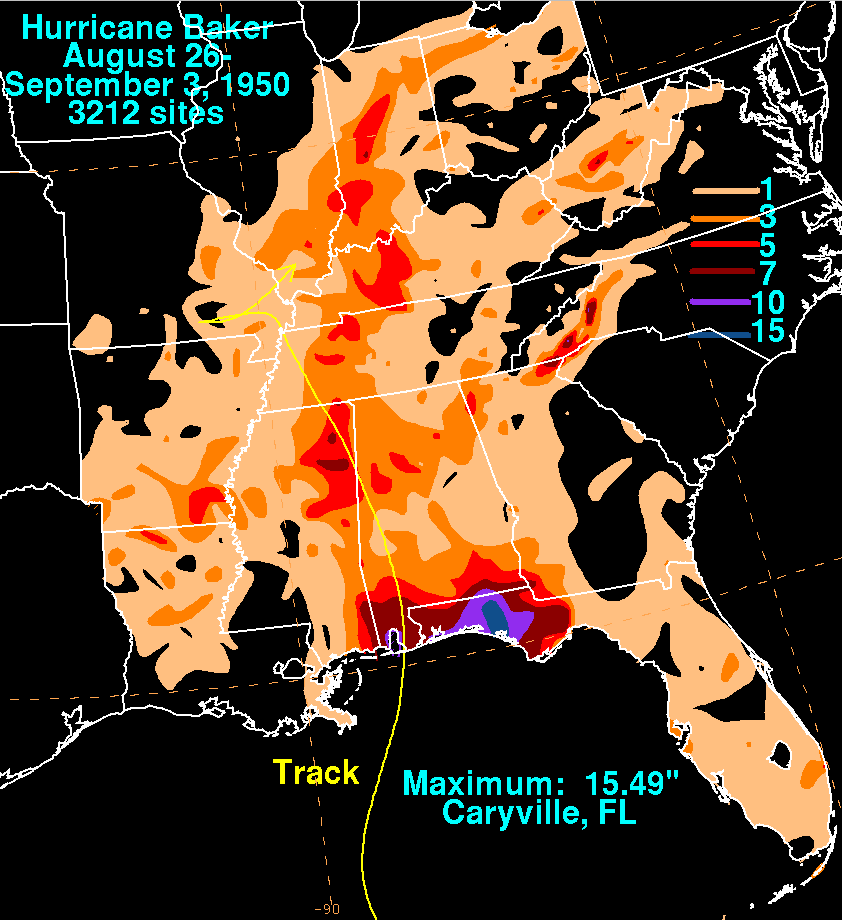
with 60 mph (75 km/h) winds, and then turned northward over the southern Gulf of Mexico. On August 28, Baker re-strengthened to hurricane intensity; reconnaissance and ship reports suggest the hurricane attained a second peak intensity of 110 mph (175 km/h) on August 30. The minimum central pressure was 979 mbar (28.92 inHg) on this date. The cyclone diminished in intensity prior to landfall. On August 31, the hurricane struck Gulf Shores, Alabama as a Category 1 hurricane with sustained winds estimated near 85 mph (140 km/h). The estimated central pressure at landfall was 980 mbar (28.95 inHg). Baker moved inland over Alabama and dissipated over southeastern Missouri on September 1.
 On Antigua, the Pan American Airways station's power failed when winds reached 85 mph (140 km/h) around midnight on August 22. Unofficial estimates placed winds between 95–120 mph (150–195 km/h) at the location, although damages and casualties were unknown. Subsequent reports indicated light damage occurred on the island; later, information from the island indicated extensive damage. More than 100 homes were destroyed or damaged in the Willkie and Piggott areas, and large homes were destroyed in Prestown. Additionally, a manse
was also demolished in Prestown. Electronic communications were dismantled, and thousands of homeless people sheltered in churches and schools. No deaths occurred on the island, but damages were expected to reach several thousand dollars. In Cuba, 37 people died, and the property losses reached several million dollars.
In the United States, the greatest property and crop damage occurred from Mobile, Alabama
to Saint Marks, Florida, where losses approached $2,550,000 (1950 USD
); high tides and winds inflicted minimal damage in both cities. Panama City, Florida
incurred heavy damage to homes and businesses from high tides and rainfall, which peaked at 14.96 inches. The highest rainfall total was 15.49 inches at Caryville, Florida
. Peak gusts exceeded 100 mph (155 km/h) on Santa Rosa Island, Florida
. 200 to 300 cottages received damage in Panama City, and homes were flooded near the bay. Losses reached $200,000 (1950 USD) in Gulf Shores, Alabama. Hurricane Baker spawned two tornado
es. On August 30, a F1 tornado
touched down in Apalachicola, Florida
, destroying four dwellings and a store building and damaging another eleven buildings. On August 31, a F0 tornado demolished one building near Marianna, Florida
, in Jackson County
. Inland, Birmingham International Airport recorded 50 mph (85 km/h) wind gusts; higher gusts were estimated near 75 mph (120 km/h) in elevated, mountainous locations. Hundreds of trees were prostrated as far north as the Birmingham, Alabama
area, and one person was killed and two more injured by live wires falling from utility poles.
Saffir-Simpson Hurricane Scale
The Saffir–Simpson Hurricane Scale , or the Saffir–Simpson Hurricane Wind Scale , classifies hurricanes — Western Hemisphere tropical cyclones that exceed the intensities of tropical depressions and tropical storms — into five categories distinguished by the intensities of their sustained winds...
that affected the Leeward Islands, Greater Antilles, and the Gulf Coast of the United States. The tropical cyclone
Tropical cyclone
A tropical cyclone is a storm system characterized by a large low-pressure center and numerous thunderstorms that produce strong winds and heavy rain. Tropical cyclones strengthen when water evaporated from the ocean is released as the saturated air rises, resulting in condensation of water vapor...
was the second intense hurricane, second hurricane, and second tropical storm of the 1950 Atlantic hurricane season. Hurricane Baker attained peak winds of 120 mph (195 km/h) near the Leeward Islands, traversed Antigua, and weakened to a tropical depression
Tropical cyclone scales
Tropical systems are officially ranked on one of several tropical cyclone scales according to their maximum sustained winds and in what oceanic basin they are located...
southwest of Puerto Rico. It re-intensified south of Cuba, strengthened to a strong Category 2 hurricane in the Gulf of Mexico, and hit the United States
United States
The United States of America is a federal constitutional republic comprising fifty states and a federal district...
near Gulf Shores, Alabama
Gulf Shores, Alabama
-External links:*...
, with winds of 85 mph (140 km/h). Hurricane Baker produced extensive damage in the Lesser Antilles and Cuba, but impacts were minimal in the United States.
Meteorological history
On the morning of August 20, a strong tropical storm developed about 446 miles (718 km) east of Basse-TerreBasse-Terre
Basse-Terre is the prefecture of Guadeloupe, an overseas region and department of France located in the Lesser Antilles...
, Guadeloupe
Guadeloupe
Guadeloupe is an archipelago located in the Leeward Islands, in the Lesser Antilles, with a land area of 1,628 square kilometres and a population of 400,000. It is the first overseas region of France, consisting of a single overseas department. As with the other overseas departments, Guadeloupe...
. The tropical storm deepened to hurricane intensity. On August 21, it rapidly attained maximum sustained winds of 120 mph (195 km/h), equivalent to a Category 3 hurricane. The hurricane passed over Antigua
Antigua
Antigua , also known as Waladli, is an island in the West Indies, in the Leeward Islands in the Caribbean region, the main island of the country of Antigua and Barbuda. Antigua means "ancient" in Spanish and was named by Christopher Columbus after an icon in Seville Cathedral, Santa Maria de la...
during the evening, while still producing winds of 115 mph (185 km/h). On August 22, it lost intensity and weakened to a tropical storm. On August 23, Baker made landfall
Landfall (meteorology)
Landfall is the event of a tropical cyclone or a waterspout coming onto land after being over water. When a waterspout makes landfall it is reclassified as a tornado, which can then cause damage inland...
near the Puerto Rican town of Guánica
Guánica, Puerto Rico
Guánica is a municipality in southwestern Puerto Rico located on southern coast, bordering the Caribbean Sea, south of Sabana Grande, east of Lajas, and west of Yauco. It is part of the Yauco Metropolitan Statistical Area....
as a minimal tropical storm. The highest winds on the island of Puerto Rico were 35–40 mph (55–65 km/h). The storm then degenerated into an easterly tropical wave
Tropical wave
Tropical waves, easterly waves, or tropical easterly waves, also known as African easterly waves in the Atlantic region, are a type of atmospheric trough, an elongated area of relatively low air pressure, oriented north to south, which move from east to west across the tropics causing areas of...
, and moved west-northwestward over northeastern Hispaniola. On August 24, it re-entered the Atlantic Ocean, and Tropical Depression Baker crossed the coast of eastern Cuba early on the next day.
On August 25, Baker redeveloped a center over the Caribbean Sea off southern Cuba, and re-intensified to tropical storm status. On August 27, Baker affected the Pinar del Río Province
Pinar del Río Province
Pinar del Río is one of the provinces of Cuba. It is at the western end of the island of Cuba.-Geography:The Pinar del Río province is Cuba's westernmost province and contains one of Cuba's three main mountain ranges, the Cordillera de Guaniguanico, divided into the easterly Sierra del Rosario and...
with 60 mph (75 km/h) winds, and then turned northward over the southern Gulf of Mexico. On August 28, Baker re-strengthened to hurricane intensity; reconnaissance and ship reports suggest the hurricane attained a second peak intensity of 110 mph (175 km/h) on August 30. The minimum central pressure was 979 mbar (28.92 inHg) on this date. The cyclone diminished in intensity prior to landfall. On August 31, the hurricane struck Gulf Shores, Alabama as a Category 1 hurricane with sustained winds estimated near 85 mph (140 km/h). The estimated central pressure at landfall was 980 mbar (28.95 inHg). Baker moved inland over Alabama and dissipated over southeastern Missouri on September 1.
Impact
Manse
A manse is a house inhabited by, or formerly inhabited by, a minister, usually used in the context of a Presbyterian, Methodist, Baptist or United Church...
was also demolished in Prestown. Electronic communications were dismantled, and thousands of homeless people sheltered in churches and schools. No deaths occurred on the island, but damages were expected to reach several thousand dollars. In Cuba, 37 people died, and the property losses reached several million dollars.
In the United States, the greatest property and crop damage occurred from Mobile, Alabama
Mobile, Alabama
Mobile is the third most populous city in the Southern US state of Alabama and is the county seat of Mobile County. It is located on the Mobile River and the central Gulf Coast of the United States. The population within the city limits was 195,111 during the 2010 census. It is the largest...
to Saint Marks, Florida, where losses approached $2,550,000 (1950 USD
United States dollar
The United States dollar , also referred to as the American dollar, is the official currency of the United States of America. It is divided into 100 smaller units called cents or pennies....
); high tides and winds inflicted minimal damage in both cities. Panama City, Florida
Panama City, Florida
-Personal income:The median income for a household in the city was $31,572, and the median income for a family was $40,890. Males had a median income of $30,401 versus $21,431 for females. The per capita income for the city was $17,830...
incurred heavy damage to homes and businesses from high tides and rainfall, which peaked at 14.96 inches. The highest rainfall total was 15.49 inches at Caryville, Florida
Caryville, Florida
Caryville is a town in Washington County, Florida, United States. The population was 218 at the 2000 census.-Geography:Caryville is located at .According to the United States Census Bureau, the town has a total area of...
. Peak gusts exceeded 100 mph (155 km/h) on Santa Rosa Island, Florida
Santa Rosa Island, Florida
Santa Rosa Island[p] is a 40-mile barrier island located in the U.S. state of Florida, thirty miles east of the Alabama state border...
. 200 to 300 cottages received damage in Panama City, and homes were flooded near the bay. Losses reached $200,000 (1950 USD) in Gulf Shores, Alabama. Hurricane Baker spawned two tornado
Tornado
A tornado is a violent, dangerous, rotating column of air that is in contact with both the surface of the earth and a cumulonimbus cloud or, in rare cases, the base of a cumulus cloud. They are often referred to as a twister or a cyclone, although the word cyclone is used in meteorology in a wider...
es. On August 30, a F1 tornado
Fujita scale
The Fujita scale , or Fujita-Pearson scale, is a scale for rating tornado intensity, based primarily on the damage tornadoes inflict on human-built structures and vegetation...
touched down in Apalachicola, Florida
Apalachicola, Florida
Apalachicola is a city in Franklin County, Florida, on US 98 about southwest of Tallahassee. The population was 2,334 at the 2000 census. The 2005 census estimated the city's population at 2,340...
, destroying four dwellings and a store building and damaging another eleven buildings. On August 31, a F0 tornado demolished one building near Marianna, Florida
Marianna, Florida
Marianna is a city in Jackson County, Florida, United States. The population was 6,230 at the 2000 census. As of 2004, the population estimated by the U.S. Census Bureau is 6,200 . It is the county seat of Jackson County and is home to Chipola College...
, in Jackson County
Jackson County, Florida
Jackson County is a county located in the U.S. state of Florida. The population as of the 2000 census was 46,755. As of 2005, the population was estimated to be 48,985 . Its county seat is Marianna, Florida.- History :...
. Inland, Birmingham International Airport recorded 50 mph (85 km/h) wind gusts; higher gusts were estimated near 75 mph (120 km/h) in elevated, mountainous locations. Hundreds of trees were prostrated as far north as the Birmingham, Alabama
Birmingham, Alabama
Birmingham is the largest city in Alabama. The city is the county seat of Jefferson County. According to the 2010 United States Census, Birmingham had a population of 212,237. The Birmingham-Hoover Metropolitan Area, in estimate by the U.S...
area, and one person was killed and two more injured by live wires falling from utility poles.
See also
- List of Florida hurricanes
- List of United States hurricanes
- List of Atlantic hurricanes
Further reading
- Barnes, Jay (1998). Florida's Hurricane History. Chapel Hill Press. ISBN 0807824437.