

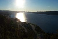
Humber Arm
Encyclopedia
Bay of Islands, Newfoundland and Labrador
The Bay of Islands is an extensive inlet located on the west coast of the island of Newfoundland, in Canada. The Way Office was established on July 1, 1883. The first Waymaster was Thomas Carter.It is also a sub-basin of the Gulf of St...
on the west coast of Newfoundland
Newfoundland and Labrador
Newfoundland and Labrador is the easternmost province of Canada. Situated in the country's Atlantic region, it incorporates the island of Newfoundland and mainland Labrador with a combined area of . As of April 2011, the province's estimated population is 508,400...
. The arm has the highest concentration of fresh water of the entire bay, due to inflow of the Humber River.
The Humber is one of the major rivers on the island of Newfoundland, making the Bay of Islands
Bay of Islands, Newfoundland and Labrador
The Bay of Islands is an extensive inlet located on the west coast of the island of Newfoundland, in Canada. The Way Office was established on July 1, 1883. The first Waymaster was Thomas Carter.It is also a sub-basin of the Gulf of St...
an important estuary. Near the mouth of the Humber River
Humber River (Newfoundland)
The Humber River is a river in the Canadian province of Newfoundland and Labrador. It is approximately 120 kilometers long, flowing through the Long Range Mountains, southeast then southwest, through Deer Lake, to the Bay of Islands at Corner Brook. It begins near Hampden, Newfoundland. Taylor's...
appropriately named "Humber Mouth", is the city of Corner Brook (2006 pop.: 20,083), as well as several neighbouring suburbs. The Humber River
Humber River (Newfoundland)
The Humber River is a river in the Canadian province of Newfoundland and Labrador. It is approximately 120 kilometers long, flowing through the Long Range Mountains, southeast then southwest, through Deer Lake, to the Bay of Islands at Corner Brook. It begins near Hampden, Newfoundland. Taylor's...
was used for many years to float logs down to the Bay of Islands
Bay of Islands, Newfoundland and Labrador
The Bay of Islands is an extensive inlet located on the west coast of the island of Newfoundland, in Canada. The Way Office was established on July 1, 1883. The first Waymaster was Thomas Carter.It is also a sub-basin of the Gulf of St...
where a large Bowater pulp and paper mill at Corner Brook turned them into paper products. Today this mill is owned by Kruger Inc and its logs are transported by truck from the Goose Arm area and the Northern Peninsula and by barge from Labrador and Quebec. Although the river is mainly used for recreational purposes, the bay still sees active shipping to and from Corner Brook's port, known as Western Terminals and is used by Oceanex and various Cruise lines, most notably the Cunard Line with the supership Queen Mary 2.
Other communities surrounding the Humber Arm include Mount Moriah
Mount Moriah, Newfoundland and Labrador
Mount Moriah is a town in the Canadian province of Newfoundland and Labrador. The town had a population of 752 in the Canada 2006 Census.- See also :* List of cities and towns in Newfoundland and Labrador...
, Humber Arm South
Humber Arm South
Humber Arm South is a town in the Canadian province of Newfoundland and Labrador. The town had a population of 1,854 in the Canada 2006 Census. The Town's Post Office is located in Benoit's Cove...
, Lark Harbour, Hughes Brook, Irishtown-Summerside, Meadows
Meadows, Newfoundland and Labrador
Meadows is a town in the Canadian province of Newfoundland and Labrador. The town had a population of 637 in the Canada 2006 Census.-See also:* List of cities and towns in Newfoundland and Labrador...
, Gillams, and McIvers.
See also
- Bay of IslandsBay of Islands, Newfoundland and LabradorThe Bay of Islands is an extensive inlet located on the west coast of the island of Newfoundland, in Canada. The Way Office was established on July 1, 1883. The first Waymaster was Thomas Carter.It is also a sub-basin of the Gulf of St...
- Humber RiverHumber River (Newfoundland)The Humber River is a river in the Canadian province of Newfoundland and Labrador. It is approximately 120 kilometers long, flowing through the Long Range Mountains, southeast then southwest, through Deer Lake, to the Bay of Islands at Corner Brook. It begins near Hampden, Newfoundland. Taylor's...
- Corner Brook
- CurlingCurling, Newfoundland and LabradorCurling is a sub-division of the city of Corner Brook, Newfoundland and Labrador. Located in the humber arm of the Bay of Islands, Curling was originally a fishing community. It is the oldest section of Corner Brook.-History:...
- Newfoundland and LabradorNewfoundland and LabradorNewfoundland and Labrador is the easternmost province of Canada. Situated in the country's Atlantic region, it incorporates the island of Newfoundland and mainland Labrador with a combined area of . As of April 2011, the province's estimated population is 508,400...