
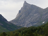
Hornindalsrokken
Encyclopedia

Stranda
Stranda is a municipality in Møre og Romsdal county, Norway. It is part of the Sunnmøre region. The administrative centre of the municipality is the village of Stranda....
(Møre og Romsdal
Møre og Romsdal
is a county in the northernmost part of Western Norway. It borders the counties of Sør-Trøndelag, Oppland and Sogn og Fjordane. The county administration is located in Molde, while Ålesund is the largest city.-The name:...
), Hornindal
Hornindal
Hornindal is a municipality in the county of Sogn og Fjordane, Norway. It is located in the traditional district of Nordfjord. The administrative centre of the municipality is the village of Grodås.Hornindal was separated from Eid in 1867...
(Sogn og Fjordane
Sogn og Fjordane
is a county in Norway, bordering Møre og Romsdal, Oppland, Buskerud, and Hordaland. The county administration is in the town of Hermansverk in Leikanger municipality while the largest town is Førde....
), and Ørsta
Ørsta
is a village and municipality in Møre og Romsdal county, Norway. It is part of the Sunnmøre region of Western Norway. The administrative centre of the municipality is the village of Ørsta...
(Møre og Romsdal
Møre og Romsdal
is a county in the northernmost part of Western Norway. It borders the counties of Sør-Trøndelag, Oppland and Sogn og Fjordane. The county administration is located in Molde, while Ålesund is the largest city.-The name:...
). The mountain is sometimes also called Honndalsrokken or sometimes just Rokken or Rokkjen.
The mountain is located about 14 kilometres (8.7 mi) northeast of the village of Grodås
Grodås
Grodås is the administrative centre of the municipality of Hornindal in Sogn og Fjordane county, Norway. The population was 374. Grodås is located along the river Horndøla on the eastern end of the lake Hornindalsvatnet, about southwest of the mountain Hornindalsrokken.The village area is a...
and lake Hornindalsvatnet
Hornindalsvatnet
Hornindalsvatnet is Norway's and Europe's deepest lake, officially measured to a depth of . Its surface is above sea level, which means that its bottom is below sea level. The village of Grodås lies at the eastern end of the lake in Hornindal and the village of Mogrenda is located on the...
in Hornindal. It is also located about 11 kilometres (6.8 mi) west of the village of Hellesylt
Hellesylt
Hellesylt is a small village in the municipality of Stranda in Møre og Romsdal county, Norway. The village lies at the head of the Sunnylvsfjord, which is a branch of the Storfjord, and which the more famous Geirangerfjord in turn branches off nearby...
in Stranda. It also lies about 6 kilometres (3.7 mi) southeast of the village of Leira
Leira, Ørsta
Leira is a small village in the Hjørundfjord area of the municipality of Ørsta in Møre og Romsdal county, Norway. It lies between Bjørke and Viddal, at the end of Hjørundfjorden...
in Ørsta. The mountain Kvitegga
Kvitegga
Kvitegga is a mountain in the municipalities of Stranda and Ørsta in Møre og Romsdal county, Norway. It is located about southeast of the village of Leira and about west of Hellesylt . The tall Kvitegga is located about northeast of the nearby mountain Hornindalsrokken.Kvitegga is the...
is 3 kilometres (1.9 mi) to the northeast on the Ørsta/Stranda boundary.
The easiest ways to climb the mountain are from the Sæterdalen valley in Hornindal
Hornindal
Hornindal is a municipality in the county of Sogn og Fjordane, Norway. It is located in the traditional district of Nordfjord. The administrative centre of the municipality is the village of Grodås.Hornindal was separated from Eid in 1867...
or from the Kjellstaddalen valley in Stranda
Stranda
Stranda is a municipality in Møre og Romsdal county, Norway. It is part of the Sunnmøre region. The administrative centre of the municipality is the village of Stranda....
. A popular viewpoint of the summit is from the Honndøla bridge which was built in 1810. The bridge lies near Riksvei
Norwegian national road
Norwegian national road , are roads thus categorized by the Norwegian Public Roads Administration which also maintains them...
60 in Indre Hornindal. North of the mountain lies the lake Tyssevatnet which is the innermost lake in the Hjørundfjorden
Hjørundfjorden
Hjørundfjorden is a fjord in the traditional district of Sunnmøre in Møre og Romsdal county, Norway. The long fjord is an arm of the larger Storfjord that stretches south from Ålesund...
area.