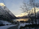
Leira, Ørsta
Encyclopedia
Leira is a small village in the Hjørundfjord
area of the municipality of Ørsta
in Møre og Romsdal
county, Norway
. It lies between Bjørke and Viddal, at the end of Hjørundfjorden
. The village is located in the Sunnmørsalpene
mountains, about 6 kilometres (3.7 mi) from the mountains Skårasalen
(to the northwest), Jakta
(to the northeast), Kvitegga
(to the southeast), and Hornindalsrokken
(to the south).
There are about 15–20 residents in Leira, with most residents farming their land. The closest urban area is the village of Volda
, about 38 kilometres (23.6 mi) to the west.
Hjørundfjord
Hjørundfjord is a former municipality in the municipality of Ørsta in Møre og Romsdal county, Norway. The administrative centre was the village of Sæbø, located on the shores of the Hjørundfjorden. The municipality encircled both sides of the Hjørundfjorden as well as the Bondalen valley...
area of the municipality of Ørsta
Ørsta
is a village and municipality in Møre og Romsdal county, Norway. It is part of the Sunnmøre region of Western Norway. The administrative centre of the municipality is the village of Ørsta...
in Møre og Romsdal
Møre og Romsdal
is a county in the northernmost part of Western Norway. It borders the counties of Sør-Trøndelag, Oppland and Sogn og Fjordane. The county administration is located in Molde, while Ålesund is the largest city.-The name:...
county, Norway
Norway
Norway , officially the Kingdom of Norway, is a Nordic unitary constitutional monarchy whose territory comprises the western portion of the Scandinavian Peninsula, Jan Mayen, and the Arctic archipelago of Svalbard and Bouvet Island. Norway has a total area of and a population of about 4.9 million...
. It lies between Bjørke and Viddal, at the end of Hjørundfjorden
Hjørundfjorden
Hjørundfjorden is a fjord in the traditional district of Sunnmøre in Møre og Romsdal county, Norway. The long fjord is an arm of the larger Storfjord that stretches south from Ålesund...
. The village is located in the Sunnmørsalpene
Sunnmørsalpene
Sunnmørsalpene is a collective term for the mountains range in Sunnmøre, Norway. The mountain range encircles the Hjørundfjorden in the municipalities of Volda, Ørsta, Stranda, and Sykkylven. These mountains have peaks reaching straight up from the fjord....
mountains, about 6 kilometres (3.7 mi) from the mountains Skårasalen
Skårasalen
Skårasalen is a mountain in the municipality of Ørsta in Møre og Romsdal county, Norway. The tall mountain has the seventh largest prominence of all mountains in Norway. The mountain is located about south of the village of Sæbø and the Bondalen valley in the Hjørundfjord area of Ørsta...
(to the northwest), Jakta
Jakta
Jakta is a tall mountain in the Sunnmørsalpene mountain range. It is located in the municipality of Ørsta in Møre og Romsdal county, Norway. Jakta lies south of the nearby mountain Slogen and just across the Hjørundfjorden from the mountain Skårasalen. The village of Leira lies south of...
(to the northeast), Kvitegga
Kvitegga
Kvitegga is a mountain in the municipalities of Stranda and Ørsta in Møre og Romsdal county, Norway. It is located about southeast of the village of Leira and about west of Hellesylt . The tall Kvitegga is located about northeast of the nearby mountain Hornindalsrokken.Kvitegga is the...
(to the southeast), and Hornindalsrokken
Hornindalsrokken
Hornindalsrokken is a tall mountain that is located on the border of the three municipalities of Stranda , Hornindal , and Ørsta...
(to the south).
There are about 15–20 residents in Leira, with most residents farming their land. The closest urban area is the village of Volda
Volda
Volda is a municipality in Møre og Romsdal county, Norway. It is part of the Sunnmøre region. The administrative centre is the village of Volda. The municipality is located about south of the city of Ålesund.-General information:...
, about 38 kilometres (23.6 mi) to the west.

