
Hillsdale, New South Wales
Encyclopedia
Hillsdale is a suburb
in south-eastern
Sydney
, in the state of New South Wales
, Australia
. Hillsdale is located 9 kilometres south-east of the Sydney central business district
in the City of Botany Bay
. The post code is 2036.
, Maroubra
, Matraville
and Banksmeadow
.
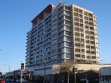
Hillsdale has a shopping centre called Southpoint on Bunnerong Road, which is a high-rise complex with commercial and residential space. The Hensley Athletic Field is located on Wentworth Avenue, opposite the Westfield Eastgardens
shopping centre. Matraville Public School is located in Hillsdale at the corner of Bunnerong and Beauchamp Roads.
. The suburb was split between Randwick and Botany Councils. When problems arose from the division in 1961, Botany Council decided to rename its portion Gilmore, to honour Australian poet Dame Mary Gilmore
(1864–1962). After the post masters general office pointed out that there already was a Gilmore, New South Wales, the council chose Hillsdale to honour Patrick Darcy Hills, who was the New South Wales minister for local government. It was a controversial choice since most residents believed that a name should have been chosen that reflected Australia's history.
Many homes were built in Hillsdale after World War II
including some by the Housing Commission.
The closest high schools are South Sydney High School
in Maroubra, Matraville Sports High School
in Chifley, and Marist College Pagewood in Maroubra.
Suburb
The word suburb mostly refers to a residential area, either existing as part of a city or as a separate residential community within commuting distance of a city . Some suburbs have a degree of administrative autonomy, and most have lower population density than inner city neighborhoods...
in south-eastern
South-eastern Sydney
South-Eastern Sydney is a term which is used to describe the metropolitan area directly to the south and east of the Sydney central business district in Sydney, New South Wales, Australia.The area stretches from the inner city to the foreshores of Botany Bay...
Sydney
Sydney
Sydney is the most populous city in Australia and the state capital of New South Wales. Sydney is located on Australia's south-east coast of the Tasman Sea. As of June 2010, the greater metropolitan area had an approximate population of 4.6 million people...
, in the state of New South Wales
New South Wales
New South Wales is a state of :Australia, located in the east of the country. It is bordered by Queensland, Victoria and South Australia to the north, south and west respectively. To the east, the state is bordered by the Tasman Sea, which forms part of the Pacific Ocean. New South Wales...
, Australia
Australia
Australia , officially the Commonwealth of Australia, is a country in the Southern Hemisphere comprising the mainland of the Australian continent, the island of Tasmania, and numerous smaller islands in the Indian and Pacific Oceans. It is the world's sixth-largest country by total area...
. Hillsdale is located 9 kilometres south-east of the Sydney central business district
Sydney central business district
The Sydney central business district is the main commercial centre of Sydney, New South Wales, Australia. It extends southwards for about 3 kilometres from Sydney Cove, the point of first European settlement. Its north–south axis runs from Circular Quay in the north to Central railway station in...
in the City of Botany Bay
City of Botany Bay
The City of Botany Bay is a Local Government Area in south eastern Sydney, in the state of New South Wales, Australia. It encompasses the suburbs to the north of Botany Bay, such as Botany. The administrative centre is located at Mascot, which is 7 km south of the Sydney central business...
. The post code is 2036.
Description
Hillsdale is a residential area surrounded by the suburbs of EastgardensEastgardens, New South Wales
Eastgardens is a suburb in the Eastern Suburbs of Sydney, specifically south-eastern Sydney, in the state of New South Wales, Australia. Eastgardens is located 9km south east of the Sydney central business district and is part of the City of Botany Bay....
, Maroubra
Maroubra, New South Wales
Maroubra is a beachside suburb in the Eastern Suburbs of Sydney, in the state of New South Wales, Australia. Maroubra is located 10 kilometres south-east of the Sydney central business district in the local government area of the City of Randwick. Maroubra is the largest suburb in the area governed...
, Matraville
Matraville, New South Wales
Matraville is an older established area of the lower Eastern Suburbs of Sydney, in the state of New South Wales, Australia. Matraville is located approximately 9 kilometres by road south-east of the Sydney central business district, in the local government area of the City of...
and Banksmeadow
Banksmeadow, New South Wales
Banksmeadow is a suburb in south-eastern Sydney, in the state of New South Wales, Australia. Banksmeadow is located 11 kilometres south-east of the Sydney central business district, in the Local Government Area of the City of Botany Bay...
.
Hillsdale has a shopping centre called Southpoint on Bunnerong Road, which is a high-rise complex with commercial and residential space. The Hensley Athletic Field is located on Wentworth Avenue, opposite the Westfield Eastgardens
Westfield Eastgardens
Westfield Eastgardens is a shopping centre that is located in the suburb of Eastgardens in Sydney, New South Wales, Australia. The centre was the largest shopping centre in Australia when it opened in September 1987. The centre is owned by the Terrace Tower Group but operated and managed on a long...
shopping centre. Matraville Public School is located in Hillsdale at the corner of Bunnerong and Beauchamp Roads.
History
Hillsdale was part of the suburb of Matraville until the 1960s. Matraville was originally reserved for the Church and Schools Corporation with income generated intended to support clergy and teachers. It reverted to the crown in 1917 and was allocated for a settlement for soldiers returning from World War IWorld War I
World War I , which was predominantly called the World War or the Great War from its occurrence until 1939, and the First World War or World War I thereafter, was a major war centred in Europe that began on 28 July 1914 and lasted until 11 November 1918...
. The suburb was split between Randwick and Botany Councils. When problems arose from the division in 1961, Botany Council decided to rename its portion Gilmore, to honour Australian poet Dame Mary Gilmore
Mary Gilmore
Dame Mary Gilmore DBE was a prominent Australian socialist poet and journalist.-Early life:Mary Jean Cameron was born on 16 August 1865 at Cotta Walla near Goulburn, New South Wales...
(1864–1962). After the post masters general office pointed out that there already was a Gilmore, New South Wales, the council chose Hillsdale to honour Patrick Darcy Hills, who was the New South Wales minister for local government. It was a controversial choice since most residents believed that a name should have been chosen that reflected Australia's history.
Many homes were built in Hillsdale after World War II
World War II
World War II, or the Second World War , was a global conflict lasting from 1939 to 1945, involving most of the world's nations—including all of the great powers—eventually forming two opposing military alliances: the Allies and the Axis...
including some by the Housing Commission.
Education
Matraville Public School is a primary school in Hillsdale, drawing its students predominantly from the surrounding suburbs of Hillsdale, Banksmeadow and Matraville. In 2007 the school had approximately 300 students from kindergarten to Year 6.The school opened as Cross Road Public School in 1903, named after the school's location at the intersection between Beauchamp and Bunnerong Roads. It was renamed as Matraville Public School in 1904.The closest high schools are South Sydney High School
South Sydney High School
South Sydney High School is a public school located in Maroubra, Sydney, New South Wales, Australia. Established in 1953 for boys, it is today a co-educational high school operated by the New South Wales Department of Education and Training for students from years 7 through 12...
in Maroubra, Matraville Sports High School
Matraville Sports High School
Matraville Sports High School, is a school located in Chifley, New South Wales, Australia, on Anzac Parade. It is a coeducational high school operated by the New South Wales Department of Education and Training with students from years 7 to 12...
in Chifley, and Marist College Pagewood in Maroubra.