

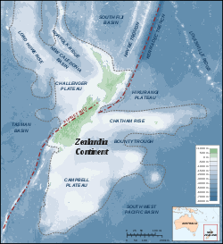
Hikurangi Plateau
Encyclopedia
Basalt
Basalt is a common extrusive volcanic rock. It is usually grey to black and fine-grained due to rapid cooling of lava at the surface of a planet. It may be porphyritic containing larger crystals in a fine matrix, or vesicular, or frothy scoria. Unweathered basalt is black or grey...
ic oceanic plateau
Oceanic plateau
An oceanic plateau is a large, relatively flat submarine region that rises well above the level of the ambient seabed. While many oceanic plateaus are composed of continental crust, and often form a step interrupting the continental slope, some plateaus are undersea remnants of large igneous...
in the southwestern Pacific Ocean
Pacific Ocean
The Pacific Ocean is the largest of the Earth's oceanic divisions. It extends from the Arctic in the north to the Southern Ocean in the south, bounded by Asia and Australia in the west, and the Americas in the east.At 165.2 million square kilometres in area, this largest division of the World...
. The portion of the plateau exposed on the seafloor has an area of 350,000 km2, and including the portions subducted beneath the
North Island
North Island
The North Island is one of the two main islands of New Zealand, separated from the much less populous South Island by Cook Strait. The island is in area, making it the world's 14th-largest island...
of New Zealand and the Chatham Rise
Chatham Rise
The Chatham Rise is an area of ocean floor to the east of New Zealand, forming part of the Zealandia continent. It stretches for some from near the South Island in the west, to the Chatham Islands in the east...
its original area was 800,000 km2. Evidence suggests that the plateau was formed in the volcanic Greater Ontong Java Event 122
million years ago, along with the Ontong Java Plateau and the Manihiki Plateau.
Hikurangi Plateau is cut by the Hikurangi Channel, a 2000 km abyssal channel
Abyssal channel
Abyssal channels are channels in Earth's sea floor. They are formed by fast-flowing floods of turbid water caused by avalanches near the channel's head, with the sediment carried by the water causing a build-up of the surrounding abyssal plains. The effect of Earth's rotation causes more sediment...
that starts at Kaikoura
Kaikoura
Kaikoura is a town on the east coast of the South Island of New Zealand. It is located on State Highway 1 180 km north of Christchurch.Kaikoura became the first local authority to reach the Green Globe tourism certification standard....
and runs along the Hikurangi Trough as far as the Mahia Peninsula
Mahia Peninsula
The Mahia Peninsula is located on the east coast of New Zealand's North Island, between the cities of Napier and Gisborne.-Geography:The peninsula is long and wide rising to its highest point at Rahuimokairoa reaching about above sea level. Mahia was initially an island which over time, has had...
before crossing the plateau and ending in the South-west Pacific abyssal plain.