
Hickling, Norfolk
Encyclopedia
Hickling is a village and a civil parish
in the English
county of Norfolk
. The village is 22 miles south-east of Cromer
, 20.3 miles north-east of Norwich
and 137 miles north-east of London
. The village lies 3 miles east of the Broadlands town of Stalham
. The nearest railway station is at Worstead
for the Bittern Line
which runs between Sheringham
, Cromer and Norwich.
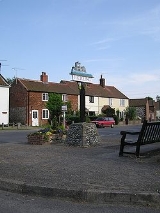
The village comprises two main parts, Hickling Green and Hickling Heath. Hickling Heath is the part which usually attracts the most tourists who come on boat trips and moor up at the staithe.
Hickling village is situated on the edge of the Hickling Broads. By using the water-ways it is possible to reach Catfield Dyke
, Potter Heigham
and even Great Yarmouth
. Because it leads to the sea the waters are slightly tidal and, depending on the time of year, the water levels can heavily rise or fall. There are many thatched huts dotted along the broads, one of the oldest being Turner's Hut.
in 1287 180 inhabitants died, when the seawater rose a foot above the high altar in the church.
Civil parish
In England, a civil parish is a territorial designation and, where they are found, the lowest tier of local government below districts and counties...
in the English
England
England is a country that is part of the United Kingdom. It shares land borders with Scotland to the north and Wales to the west; the Irish Sea is to the north west, the Celtic Sea to the south west, with the North Sea to the east and the English Channel to the south separating it from continental...
county of Norfolk
Norfolk
Norfolk is a low-lying county in the East of England. It has borders with Lincolnshire to the west, Cambridgeshire to the west and southwest and Suffolk to the south. Its northern and eastern boundaries are the North Sea coast and to the north-west the county is bordered by The Wash. The county...
. The village is 22 miles south-east of Cromer
Cromer
Cromer is a coastal town and civil parish in north Norfolk, England. The local government authority is North Norfolk District Council, whose headquarters is in Holt Road in the town. The town is situated 23 miles north of the county town, Norwich, and is 4 miles east of Sheringham...
, 20.3 miles north-east of Norwich
Norwich
Norwich is a city in England. It is the regional administrative centre and county town of Norfolk. During the 11th century, Norwich was the largest city in England after London, and one of the most important places in the kingdom...
and 137 miles north-east of London
London
London is the capital city of :England and the :United Kingdom, the largest metropolitan area in the United Kingdom, and the largest urban zone in the European Union by most measures. Located on the River Thames, London has been a major settlement for two millennia, its history going back to its...
. The village lies 3 miles east of the Broadlands town of Stalham
Stalham
Stalham is a market town on the River Ant in the English county of Norfolk, in East Anglia. It covers an area of and had a population of 2,951 in 1,333 households as of the 2001 census. It lies within the Norfolk Broads, about north-east of Norwich on the A149 road.For the purposes of local...
. The nearest railway station is at Worstead
Worstead railway station
Worstead is a railway station situated about 1 km distant from the villages of Worstead and Sloley in the English county of Norfolk. The station is served by local services operated by National Express East Anglia on the Bittern Line from Norwich to Cromer and Sheringham.-Train Services:The...
for the Bittern Line
Bittern Line
The Bittern Line is a railway line from Norwich to Cromer then Sheringham in Norfolk, England. It is one of the most scenic in the East of England traversing the Norfolk Broads on its route to the Area of Outstanding Natural Beauty on the North Norfolk Coast. The line is part of the Network Rail...
which runs between Sheringham
Sheringham
Sheringham is a seaside town in Norfolk, England, west of Cromer.The motto of the town, granted in 1953 to the Sheringham Urban District Council, is Mare Ditat Pinusque Decorat, Latin for "The sea enriches and the pine adorns"....
, Cromer and Norwich.
The village comprises two main parts, Hickling Green and Hickling Heath. Hickling Heath is the part which usually attracts the most tourists who come on boat trips and moor up at the staithe.
Hickling village is situated on the edge of the Hickling Broads. By using the water-ways it is possible to reach Catfield Dyke
Catfield
Catfield is a village and a civil parish in the English county of Norfolk. The village is south-east of Cromer, north-east of Norwich and north-east of London. The village lies south-south-east of the nearby town of Stalham. The nearest railway station is at Worstead for the Bittern Line which...
, Potter Heigham
Potter Heigham
Potter Heigham is a village and civil parish on the River Thurne in the English county of Norfolk. It is situated some north-east of the city of Norwich on the A149 road, and on The Broads....
and even Great Yarmouth
Great Yarmouth
Great Yarmouth, often known to locals as Yarmouth, is a coastal town in Norfolk, England. It is at the mouth of the River Yare, east of Norwich.It has been a seaside resort since 1760, and is the gateway from the Norfolk Broads to the sea...
. Because it leads to the sea the waters are slightly tidal and, depending on the time of year, the water levels can heavily rise or fall. There are many thatched huts dotted along the broads, one of the oldest being Turner's Hut.
History
During the St. Lucia's floodSt. Lucia's flood
St. Lucia's flood was a storm tide that affected the Netherlands and Northern Germany on December 14, 1287 when a dike broke during a storm, killing approximately 50,000 to 80,000 people in the fifth largest flood in recorded history. Much land was permanently flooded in what is now the Waddenzee...
in 1287 180 inhabitants died, when the seawater rose a foot above the high altar in the church.