
Hell Hole Reservoir
Encyclopedia
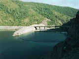
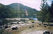
Hell Hole reservoir is an artificial, crescent-shaped lake in the Sierra Nevada mountain range 10 miles (16.1 km) west of Lake Tahoe
in California. The lake is about 3.5 miles (5.6 km) long when at full capacity.
The lake was created in 1966 with the completion of Lower Hell Hole Dam across the Rubicon River
, which is a major tributary of the Middle Fork of the American River
. Hell Hole is named for a deep canyon which is now under the waters of the lake.
How the canyon came to be named Hell Hole is a combination of folklore and speculation. An early author, George Wharton James
(1858–1923), visited the canyon in 1913. James attributed the name to an unidentified miner seeking riches during the Squaw Valley mining excitement of 1862. It was "a hell of hole to get out of," James wrote but admitted his source for the place name was more speculative than the anonymous miner's chances for riches at Squaw Valley.
James' guide for the 1913 camping expedition to Hell Hole was Bob Watson, a well-known camping guide who operated in the Lake Tahoe Region from the 1880s into the first decades of the 20th century. Watson may have been the source of the story who sought to entertain and edify his paying clients with tales of local history. James attributed much of the local lore to Watson.
The United States Board on Geographic Names
attributes the first use of the name "Hell Hole" to a United States Geological Survey map of 1894. The board was created in 1890, so previous uses of the name on federal government maps are possible.
James reported finding a natural lake near the Hell Hole chasm known as Bear Lake, which would have been drowned by the reservoir. James also described Hell Hole in terms that belies the colorful name: "Hell Hole? Then give me more of it," he wrote. The author reported his pleasure of the canyon was derived from its rugged nature that precluded human exploitation: Logging, mining, water development and road building, evident in other portions of the Lake Tahoe region. It was "a paradise of delightful surprises," he wrote.
and Tahoe
national forests. The water agency gained its power from financing approved by Placer County voters in 1961.
Proposals for the dam date to 1958. In 1964 the first Hell Hole dam was completed. Placer County sought drinking water supplies to fuel growth of its communities in the Sacramento Valley
. The gold-rush-era town of Auburn
is in Placer County as is the suburban community of Roseville
. The agency also sought to generate hydroelectric power to finance its ability to deliver the water to users.
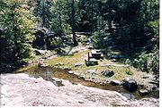 The lake is known by its three components: Lower Hell Hole, the Narrows and Upper Hell Hole. The lake is accessible by motor vehicle only at Lower Hell Hole, where a paved launch facility and forest service ranger station are located. The Hell Hole campground is also located there.
The campground features a view of the polished granite lakeshore but is not located directly on the shore of the lake because of the steep grade. The campground features a parking area but the 10 campsites are walk-in only. Many visitors use Big Meadows campground about one mile (1.6 km) away, which has 54 drive-in campsites suitable for recreational vehicles.
A second forest service campground is maintained at Upper Hell Hole and is known by that name. It can be reached by boat or a 3.5 miles (5.6 km) hiking trail that is reached by crossing the breakwater of the dam and hiking on a trail that flanks the lake but is several hundred feet above the water.
Upper Hell Hole campground is said to have 15 campsites and two pit toilets, but does not have trash service or other amenities. A camping fee is not charged. The campground is arranged on three tiers of elevation. Steps are cut into the granite rock to connect the levels. During the spring and early summer snowmelt, several of the campsites feature creeks and waterfalls nearby. Other campsites there are sheltered by giant granite boulders. Camping is also permitted wherever the rugged shoreline will permit boat landing.
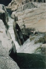
 The lake's principal inflows are from the Rubicon River and Five Lakes Creek, formerly a tributary of the Rubicon. Lake water has drowned the historical confluence of the two water courses. The Rubicon River was once known as the south fork of the middle fork of the American River. The Rubicon River's entry into the lake is via a cataract where the river has eroded through the elevated granite block.
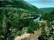
The lake also features many small granitic islands that expand and contract with the level of the lake. Hell Hole typically has its highest level of water in May and lowers gradually through the summer and fall. The forest service maintains visitor services from May 15 through September 15. The lake is accessible until snow makes roads to the area impassable.
In 1984, the federally protected Granite Chief Wilderness was created by the United States Congress
after a long advocacy campaign by the Sierra Club
, a conservation organization.
Upper Hell Hole forms the western border of the Granite Chief Wilderness. A small buffer zone between the lake shore and the wilderness prevents accidental intrusion into the wilderness. The juxtaposition of the lake and wilderness presents the opportunity for rustic boat/backpacking adventures through the rugged and scenic 25680 acres (103.9 km²) of wilderness. Like the lake itself, the wilderness is lightly used on the western border. Hell Hole Trail enters the wilderness from near the lake but is difficult to locate. Granite Chief Wilderness is managed by the Tahoe National Forest
, while visitor facilities at Hell Hole are exclusively managed by El Dorado National Forest (Georgetown district).
The Truckee and American River (formerly Foresthill) ranger districts of the Tahoe forest advise caution at Granite Chief: "Topographic maps and skills to use them are highly recommended in the wilderness because of the minimal level in signing and remoteness of the area." Wilderness permits are not required to enter the Granite Chief Wilderness. Campfire permits are always required.
Water for hydroelectric generation is also shuttled into Hell Hole from French Meadows Reservoir
which impounds the Middle Fork of the American River. The water travels through a tunnel to a powerhouse located on the north side of Hell Hole. French Meadows, at 5,200 elevation, is higher than the 4700 feet (1,432.6 m) elevation at Hell Hole. The powerhouse at Hell Hole is actually known by the name, French Meadows powerhouse.
The traditional channel of the Rubicon River still maintains water flow from the spillway at Hell Hole Dam and from tributaries of the Rubicon below the dam, such as Gerle Creek .
The Placer County Water Agency does not take water directly from Hell Hole or the other dam but instead claims rights to the water as it is shipped through the American River System and ends up at Folsom Lake
near Sacramento
. Folsom dam was originally constructed for the purposes of flood control. The Placer water agency's dams and Ralston are presently known as the Middle Fork Project.
The gold rush of 1849 on the South Fork of the American River resulted in establishment of Sierra foothill towns of Auburn, Placerville
, Nevada City
and Georgetown
. The gold rush did not intrude into the higher elevations of the Sierra Nevada range, but the water and timber needs of these towns did intrude into the upper elevations. In one case in 1873 the privately owned, California Water Company employed a scheme to dam Loon Lake
to the south of Hell Hole and then sluice the water closer to Georgetown where it could be used by residents and farmers.
Somewhat later, in 1862, the residents of Placer County (Auburn, Foresthill) came upon a scheme to build a road from the Foresthill divide to Squaw Valley with the intent of luring immigrant trains away from Nevada City and into Placerville and neighboring vicinities. George Wharton James, the author, described the road as an ill-fated enterprise: "The grade is frightful. For an hour or more, we go slowly up it stopping every few yards or so to give our horses breath," James wrote of a ride on the old road a half century after it was built. "It is hard enough for horses to go up this grade but to pull heavily-ladened (sic) wagons - it seems impossible, " he concluded. Later attempts to improve this road or forge other wagon roads not successful.
The Comstock Lode
silver rush in the 1860s in Nevada Territory also encouraged the attempt of the gold-rush foothillers to find pathways over the mountains to the riches of the Comstock and the more local Squaw Valley silver excitement.
The roads then brought timber claimants and homesteaders, called locators, who were able to claim public lands. The old homesteads and timber claims were bought by private water companies or hoteliers who sought visitors to the "healthful" mineral springs after much of the timber was depleted by the mid-1880s.
Railroads brought the tourists. Tourists could reach Truckee, California
by rail from either San Francisco or Ogden, Utah
by the end of the 19th century. The Tahoe Railway and Transportation Company brought them to the lake. One particular resort established east of Hell Hole has a significant relationship to the canyon. Deer Park, just south of Squaw Valley (now a ski area and home to the 1960 Winter Olympics) was a tourist hotel which had a rustic hideaway camp at Five Lakes now in Granite Chief Wilderness. James described the Five Lakes resort as a 160 acre (0.6474976 km²) timber claim in which the timber had never been cut but in which cabins had been built and rowboats kept in hand for fishing upon the five small lakes.
The Five Lakes are the headwaters of Five Lakes Creek which led James on his 1913 horseback descent into Hell Hole in the company of Bob Watson, the guide. The pair camped at Hell Hole, then ascended the Rubicon River to Rockbound Lake, where they camped again. Rockbound Lake is now in the Desolation Wilderness and is near the headwaters of the Rubicon River. The Sacramento Municipal Utility District controls a dam within the Desolation Wilderness
: Rubicon Reservoir. Desolation Wilderness was created in 1969.
 Placer County's 1961 bond approval allowed its water agency to seek out water supplies that were not already claimed by others. Loon Lake, south of Hell Hole, was already prescripted, but the rugged, untouched Hell Hole was not. In 1934, the State of California took steps to claim any unclaimed water rights along the American River's three forks. In 1962 the rights to the Rubicon River water were conveyed to Placer County.
The Hell Hole dam, a rock-fill
-type dam, was completed across the Rubicon River in December 1964. As the reservoir began filling the dam sprung a leak during a flood event and failed completely the next day. The resulting flood washed down the Middle Fork of the American River and washed away the Greenville Bridge near Auburn.
The Placer County Water Agency began a new dam which was completed two years later and has now stood for 42 years.
Lake Tahoe
Lake Tahoe is a large freshwater lake in the Sierra Nevada of the United States. At a surface elevation of , it is located along the border between California and Nevada, west of Carson City. Lake Tahoe is the largest alpine lake in North America. Its depth is , making it the USA's second-deepest...
in California. The lake is about 3.5 miles (5.6 km) long when at full capacity.
The lake was created in 1966 with the completion of Lower Hell Hole Dam across the Rubicon River
Rubicon River (California)
The Rubicon River is a river in the Sierra Nevada of northern California, west of Lake Tahoe. It is a tributary of the Middle Fork American River, and is long and with a watershed of about . The river's headwaters are in the Crystal Range of the Sierra Nevada, within the Eldorado National Forest's...
, which is a major tributary of the Middle Fork of the American River
American River
The American River is a California watercourse noted as the site of Sutter's Mill, northwest of Placerville, California, where gold was found in 1848, leading to the California Gold Rush...
. Hell Hole is named for a deep canyon which is now under the waters of the lake.
How the canyon came to be named Hell Hole is a combination of folklore and speculation. An early author, George Wharton James
George Wharton James
George Wharton James was a prolific popular lecturer and journalist, writing more than 40 books and many articles and pamphlets on California and the American Southwest....
(1858–1923), visited the canyon in 1913. James attributed the name to an unidentified miner seeking riches during the Squaw Valley mining excitement of 1862. It was "a hell of hole to get out of," James wrote but admitted his source for the place name was more speculative than the anonymous miner's chances for riches at Squaw Valley.
James' guide for the 1913 camping expedition to Hell Hole was Bob Watson, a well-known camping guide who operated in the Lake Tahoe Region from the 1880s into the first decades of the 20th century. Watson may have been the source of the story who sought to entertain and edify his paying clients with tales of local history. James attributed much of the local lore to Watson.
The United States Board on Geographic Names
United States Board on Geographic Names
The United States Board on Geographic Names is a United States federal body whose purpose is to establish and maintain uniform usage of geographic names throughout the U.S. government.-Overview:...
attributes the first use of the name "Hell Hole" to a United States Geological Survey map of 1894. The board was created in 1890, so previous uses of the name on federal government maps are possible.
James reported finding a natural lake near the Hell Hole chasm known as Bear Lake, which would have been drowned by the reservoir. James also described Hell Hole in terms that belies the colorful name: "Hell Hole? Then give me more of it," he wrote. The author reported his pleasure of the canyon was derived from its rugged nature that precluded human exploitation: Logging, mining, water development and road building, evident in other portions of the Lake Tahoe region. It was "a paradise of delightful surprises," he wrote.
Current conditions
Lower Hell Hole Dam (its official name) is operated by the Placer County Water Agency, a powerful political force in the region. The agency controls two dams in the EldoradoEldorado National Forest
Eldorado National Forest is a U.S. National Forest located in the central Sierra Nevada mountain range, in eastern Eldorado National Forest is a [[U.S. National Forest]] located in the central [[Sierra Nevada |Sierra Nevada]] [[mountain range]], in eastern Eldorado National Forest is a [[U.S...
and Tahoe
Tahoe National Forest
Tahoe National Forest is a U.S. National Forest located in the state of California, northwest of Lake Tahoe. It includes the peak of Sierra Buttes, near Sierra City, which has views of Mount Lassen and Mount Shasta. It is located in parts of six counties. In descending order of forestland area...
national forests. The water agency gained its power from financing approved by Placer County voters in 1961.
Proposals for the dam date to 1958. In 1964 the first Hell Hole dam was completed. Placer County sought drinking water supplies to fuel growth of its communities in the Sacramento Valley
Sacramento Valley
The Sacramento Valley is the portion of the California Central Valley that lies to the north of the San Joaquin-Sacramento Delta in the U.S. state of California. It encompasses all or parts of ten counties.-Geography:...
. The gold-rush-era town of Auburn
Auburn, California
Auburn is the county seat of Placer County, California. Its population at the 2010 census was 13,330. Auburn is known for its California Gold Rush history.Auburn is part of the Greater Sacramento area.- History :...
is in Placer County as is the suburban community of Roseville
Roseville, California
-2010:The 2010 United States Census reported that Roseville had a population of 118,788. The population density was 3,279.4 people per square mile...
. The agency also sought to generate hydroelectric power to finance its ability to deliver the water to users.
Recreational uses
Today, the lake offers modern facilities to aid in waterborne recreation. The remoteness of the lake limits the number of visitors, so the lake is seldom crowded even during the height of the summer season. Most boating activity is limited to small powered fishing skiffs, canoes and kayaks. Afternoon high winds can make boating precarious.The campground features a view of the polished granite lakeshore but is not located directly on the shore of the lake because of the steep grade. The campground features a parking area but the 10 campsites are walk-in only. Many visitors use Big Meadows campground about one mile (1.6 km) away, which has 54 drive-in campsites suitable for recreational vehicles.
A second forest service campground is maintained at Upper Hell Hole and is known by that name. It can be reached by boat or a 3.5 miles (5.6 km) hiking trail that is reached by crossing the breakwater of the dam and hiking on a trail that flanks the lake but is several hundred feet above the water.
Upper Hell Hole campground is said to have 15 campsites and two pit toilets, but does not have trash service or other amenities. A camping fee is not charged. The campground is arranged on three tiers of elevation. Steps are cut into the granite rock to connect the levels. During the spring and early summer snowmelt, several of the campsites feature creeks and waterfalls nearby. Other campsites there are sheltered by giant granite boulders. Camping is also permitted wherever the rugged shoreline will permit boat landing.
The lake also features many small granitic islands that expand and contract with the level of the lake. Hell Hole typically has its highest level of water in May and lowers gradually through the summer and fall. The forest service maintains visitor services from May 15 through September 15. The lake is accessible until snow makes roads to the area impassable.
In 1984, the federally protected Granite Chief Wilderness was created by the United States Congress
United States Congress
The United States Congress is the bicameral legislature of the federal government of the United States, consisting of the Senate and the House of Representatives. The Congress meets in the United States Capitol in Washington, D.C....
after a long advocacy campaign by the Sierra Club
Sierra Club
The Sierra Club is the oldest, largest, and most influential grassroots environmental organization in the United States. It was founded on May 28, 1892, in San Francisco, California, by the conservationist and preservationist John Muir, who became its first president...
, a conservation organization.
Upper Hell Hole forms the western border of the Granite Chief Wilderness. A small buffer zone between the lake shore and the wilderness prevents accidental intrusion into the wilderness. The juxtaposition of the lake and wilderness presents the opportunity for rustic boat/backpacking adventures through the rugged and scenic 25680 acres (103.9 km²) of wilderness. Like the lake itself, the wilderness is lightly used on the western border. Hell Hole Trail enters the wilderness from near the lake but is difficult to locate. Granite Chief Wilderness is managed by the Tahoe National Forest
Tahoe National Forest
Tahoe National Forest is a U.S. National Forest located in the state of California, northwest of Lake Tahoe. It includes the peak of Sierra Buttes, near Sierra City, which has views of Mount Lassen and Mount Shasta. It is located in parts of six counties. In descending order of forestland area...
, while visitor facilities at Hell Hole are exclusively managed by El Dorado National Forest (Georgetown district).
The Truckee and American River (formerly Foresthill) ranger districts of the Tahoe forest advise caution at Granite Chief: "Topographic maps and skills to use them are highly recommended in the wilderness because of the minimal level in signing and remoteness of the area." Wilderness permits are not required to enter the Granite Chief Wilderness. Campfire permits are always required.
Hydrology
The construction of the present Hell Hole Dam also changed the course of the Rubicon River. The pre-dam river channel wended its way several miles to its confluence with the Middle Fork of the American River near Ralston Afterbay. Now, In addition to releases from Hell Hole down the pre-dam path, water is diverted through a pipeline to Middle Fork Powerhouse (AKA Stephenson Powerhouse) where it flows into Interbay Reservoir. From here, in addition to releases down the Middle Fork American River, the water is diverted into a tunnel to Ralston Powerhouse and into Ralston Afterbay, where it joins water from the pre-dam path. Oxbow Powerhouse and Oxbow control dam there releases water into the middle fork of the American River just below the spot of the historical confluence.Water for hydroelectric generation is also shuttled into Hell Hole from French Meadows Reservoir
French Meadows Reservoir
French Meadows Reservoir is a manmade lake northeast of Foresthill, California United States. on the Middle Fork of the American River. The reservoir is long, wide, with of shoreline....
which impounds the Middle Fork of the American River. The water travels through a tunnel to a powerhouse located on the north side of Hell Hole. French Meadows, at 5,200 elevation, is higher than the 4700 feet (1,432.6 m) elevation at Hell Hole. The powerhouse at Hell Hole is actually known by the name, French Meadows powerhouse.
The traditional channel of the Rubicon River still maintains water flow from the spillway at Hell Hole Dam and from tributaries of the Rubicon below the dam, such as Gerle Creek .
The Placer County Water Agency does not take water directly from Hell Hole or the other dam but instead claims rights to the water as it is shipped through the American River System and ends up at Folsom Lake
Folsom Lake
Folsom Lake is a reservoir in Northern California about northeast of Sacramento in Placer, El Dorado, and Sacramento Counties. The lake is formed by Folsom Dam, constructed in 1955 to control the American River. The dam and lake are part of the Folsom Project, which also includes the Nimbus...
near Sacramento
Sacramento, California
Sacramento is the capital city of the U.S. state of California and the county seat of Sacramento County. It is located at the confluence of the Sacramento River and the American River in the northern portion of California's expansive Central Valley. With a population of 466,488 at the 2010 census,...
. Folsom dam was originally constructed for the purposes of flood control. The Placer water agency's dams and Ralston are presently known as the Middle Fork Project.
Historical usage
Hell Hole canyon and nearby vicinities initially escaped man-made exploitation during the latter half of the 19th century, but events that occurred then allowed eventual exploitation of Hell Hole during the 1960s.The gold rush of 1849 on the South Fork of the American River resulted in establishment of Sierra foothill towns of Auburn, Placerville
Placerville, California
Placerville is the county seat of El Dorado County, California. The population was 10,389 at the 2010 census, up from 9,610 at the 2000 census. It is part of the Sacramento–Arden-Arcade–Roseville Metropolitan Statistical Area.-Geography:...
, Nevada City
Nevada City, California
-2010:The 2010 United States Census reported that Nevada City had a population of 3,068. The population density was 1,399.7 people per square mile . The racial makeup of Nevada City was 2,837 White, 26 African American, 28 Native American, 46 Asian, 0 Pacific Islander, 40 from other races,...
and Georgetown
Georgetown, California
Georgetown is a census-designated place in El Dorado County, California. It is the northeastern-most town in the Californian Mother Lode. The population was 2,367 at the 2010 census, up from 962 at the 2000 census...
. The gold rush did not intrude into the higher elevations of the Sierra Nevada range, but the water and timber needs of these towns did intrude into the upper elevations. In one case in 1873 the privately owned, California Water Company employed a scheme to dam Loon Lake
Loon Lake (California)
Loon Lake Reservoir is a reservoir in the El Dorado National Forest of El Dorado County, California, United States. The lake is formed by Loon Lake Dam, completed in 1963 by Sacramento Municipal Utility District to conserve spring snow melt runoff for use during the summer and autumn for...
to the south of Hell Hole and then sluice the water closer to Georgetown where it could be used by residents and farmers.
Somewhat later, in 1862, the residents of Placer County (Auburn, Foresthill) came upon a scheme to build a road from the Foresthill divide to Squaw Valley with the intent of luring immigrant trains away from Nevada City and into Placerville and neighboring vicinities. George Wharton James, the author, described the road as an ill-fated enterprise: "The grade is frightful. For an hour or more, we go slowly up it stopping every few yards or so to give our horses breath," James wrote of a ride on the old road a half century after it was built. "It is hard enough for horses to go up this grade but to pull heavily-ladened (sic) wagons - it seems impossible, " he concluded. Later attempts to improve this road or forge other wagon roads not successful.
The Comstock Lode
Comstock Lode
The Comstock Lode was the first major U.S. discovery of silver ore, located under what is now Virginia City, Nevada, on the eastern slope of Mount Davidson, a peak in the Virginia Range. After the discovery was made public in 1859, prospectors rushed to the area and scrambled to stake their claims...
silver rush in the 1860s in Nevada Territory also encouraged the attempt of the gold-rush foothillers to find pathways over the mountains to the riches of the Comstock and the more local Squaw Valley silver excitement.
The roads then brought timber claimants and homesteaders, called locators, who were able to claim public lands. The old homesteads and timber claims were bought by private water companies or hoteliers who sought visitors to the "healthful" mineral springs after much of the timber was depleted by the mid-1880s.
Railroads brought the tourists. Tourists could reach Truckee, California
Truckee, California
Truckee is an incorporated town in Nevada County, California, United States. The population was 16,180 at the 2010 census, up from 13,864 at the 2000 census.-Name:...
by rail from either San Francisco or Ogden, Utah
Ogden, Utah
Ogden is a city in Weber County, Utah, United States. Ogden serves as the county seat of Weber County. The population was 82,825 according to the 2010 Census. The city served as a major railway hub through much of its history, and still handles a great deal of freight rail traffic which makes it a...
by the end of the 19th century. The Tahoe Railway and Transportation Company brought them to the lake. One particular resort established east of Hell Hole has a significant relationship to the canyon. Deer Park, just south of Squaw Valley (now a ski area and home to the 1960 Winter Olympics) was a tourist hotel which had a rustic hideaway camp at Five Lakes now in Granite Chief Wilderness. James described the Five Lakes resort as a 160 acre (0.6474976 km²) timber claim in which the timber had never been cut but in which cabins had been built and rowboats kept in hand for fishing upon the five small lakes.
The Five Lakes are the headwaters of Five Lakes Creek which led James on his 1913 horseback descent into Hell Hole in the company of Bob Watson, the guide. The pair camped at Hell Hole, then ascended the Rubicon River to Rockbound Lake, where they camped again. Rockbound Lake is now in the Desolation Wilderness and is near the headwaters of the Rubicon River. The Sacramento Municipal Utility District controls a dam within the Desolation Wilderness
Desolation Wilderness
The Desolation Wilderness is a federally protected wilderness area located along the crest of the Sierra Nevada mountain range, just southwest of Lake Tahoe in El Dorado County, California, United States. It is a popular backpacking destination, with much barren rocky terrain at the edge of the...
: Rubicon Reservoir. Desolation Wilderness was created in 1969.
Recent history
The Hell Hole dam, a rock-fill
Embankment dam
An embankment dam is a massive artificial water barrier. It is typically created by the emplacement and compaction of a complex semi-plastic mound of various compositions of soil, sand, clay and/or rock. It has a semi-permanent waterproof natural covering for its surface, and a dense, waterproof...
-type dam, was completed across the Rubicon River in December 1964. As the reservoir began filling the dam sprung a leak during a flood event and failed completely the next day. The resulting flood washed down the Middle Fork of the American River and washed away the Greenville Bridge near Auburn.
The Placer County Water Agency began a new dam which was completed two years later and has now stood for 42 years.