
Hazlemere
Encyclopedia
Hazlemere is a suburb of High Wycombe
and a civil parish within Wycombe district in Buckinghamshire
, England
. It is to the north east of the town
along the A404
in the direction of Amersham
.
Hazlemere used to be a small hamlet in the ancient Desborough Hundred
and the name is recorded as long ago as the 13th century. The crossroads at the centre of Hazlemere was, until 1987, the meeting point of several parish boundaries (Penn
, Hughenden
, Chepping Wycombe
). It now lies at the centre of its own parish. In the Victorian era
the railway arrived in High Wycombe, and the principal station in the town was on Amersham Hill, close to the village of Hazlemere. From that point on, it was perhaps inevitable that Hazlemere would become a large built-up area.
A secondary part of Hazlemere was developed chiefly in the 1960s in the area around 'Cosy Corner' (the junction where Eastern and Western Dene meet) and extending into Hazlemere Park (Cedar Avenue development). The Park Parade Shopping Centre, developed at the same time, lies at the centre of this area. This area also accommodated Cedars First School and Park Middle School, which merged as Cedars Park School in 1999.
To the north of Cosy Corner up Brimmers Hill and Primrose Hill is Widmer End
. To the north east of Cosy Corner up Sawpit Hill is Holmer Green
and the boundary for Chiltern District.
A further part of Hazlemere was developed during the 1970s to the south of Hazlemere crossroads around Rose Avenue. A secondary school – the Sir William Ramsay School
– three Primary Schools namely Manor Farm Infant School, Manor Farm Junior School and Hazlemere C of E school– a library and health centre were built around the same time.
Hazlemere's most expensive residential road is Manor Road, part of the St John's area running along the east side of Kings Wood from the A404 to the edge of Penn.
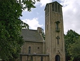
Holy Trinity Church's tall bell tower is a local landmark, with some traditional local flint-faced houses nearby.
Hazlemere has proved to be an accessible starting point for cycling across the Chiltern Hills and each year it becomes the headquarters for the annual Archer Grand Prix road race.
High Wycombe
High Wycombe , commonly known as Wycombe and formally called Chepping Wycombe or Chipping Wycombe until 1946,is a large town in Buckinghamshire, England. It is west-north-west of Charing Cross in London; this figure is engraved on the Corn Market building in the centre of the town...
and a civil parish within Wycombe district in Buckinghamshire
Buckinghamshire
Buckinghamshire is a ceremonial and non-metropolitan home county in South East England. The county town is Aylesbury, the largest town in the ceremonial county is Milton Keynes and largest town in the non-metropolitan county is High Wycombe....
, England
England
England is a country that is part of the United Kingdom. It shares land borders with Scotland to the north and Wales to the west; the Irish Sea is to the north west, the Celtic Sea to the south west, with the North Sea to the east and the English Channel to the south separating it from continental...
. It is to the north east of the town
Town
A town is a human settlement larger than a village but smaller than a city. The size a settlement must be in order to be called a "town" varies considerably in different parts of the world, so that, for example, many American "small towns" seem to British people to be no more than villages, while...
along the A404
A404 road
The A404 is a road in the United Kingdom that starts at Paddington in London and leads to Maidenhead in Berkshire.The road initially follows a course through London and its suburbs including Harlesden, Wembley, Harrow Pinner, and Rickmansworth...
in the direction of Amersham
Amersham
Amersham is a market town and civil parish within Chiltern district in Buckinghamshire, England, 27 miles north west of London, in the Chiltern Hills. It is part of the London commuter belt....
.
Hazlemere used to be a small hamlet in the ancient Desborough Hundred
Desborough (hundred)
Desborough Hundred is a hundred in Buckinghamshire, England. It is situated in the south of the county and is bounded on the west by Oxfordshire and on the south the River Thames marked the boundary with Berkshire.-History:...
and the name is recorded as long ago as the 13th century. The crossroads at the centre of Hazlemere was, until 1987, the meeting point of several parish boundaries (Penn
Penn, Buckinghamshire
Penn is a village and civil parish in Chiltern district in Buckinghamshire, England, about north-west of Beaconsfield and east of High Wycombe...
, Hughenden
Hughenden Valley
Hughenden Valley is an extensive village and civil parish within Wycombe district in Buckinghamshire, England, just to the north of High Wycombe...
, Chepping Wycombe
Chepping Wycombe
Chepping Wycombe is a civil parish within Wycombe district in the ceremonial county of Buckinghamshire. The parish includes the three large villages of Tylers Green, Loudwater and Flackwell Heath...
). It now lies at the centre of its own parish. In the Victorian era
Victorian era
The Victorian era of British history was the period of Queen Victoria's reign from 20 June 1837 until her death on 22 January 1901. It was a long period of peace, prosperity, refined sensibilities and national self-confidence...
the railway arrived in High Wycombe, and the principal station in the town was on Amersham Hill, close to the village of Hazlemere. From that point on, it was perhaps inevitable that Hazlemere would become a large built-up area.
A secondary part of Hazlemere was developed chiefly in the 1960s in the area around 'Cosy Corner' (the junction where Eastern and Western Dene meet) and extending into Hazlemere Park (Cedar Avenue development). The Park Parade Shopping Centre, developed at the same time, lies at the centre of this area. This area also accommodated Cedars First School and Park Middle School, which merged as Cedars Park School in 1999.
To the north of Cosy Corner up Brimmers Hill and Primrose Hill is Widmer End
Widmer End
Widmer End is a hamlet in the parish of Hughenden, in Buckinghamshire, England.The Village of Widmer End is situated about three miles north of High Wycombe town centre...
. To the north east of Cosy Corner up Sawpit Hill is Holmer Green
Holmer Green
Historically, Holmer Green was a small hamlet in the parish of Little Missenden, in Buckinghamshire, England. Today it is considered a village in its own right even though it looks to the casual observer like a far corner of High Wycombe...
and the boundary for Chiltern District.
A further part of Hazlemere was developed during the 1970s to the south of Hazlemere crossroads around Rose Avenue. A secondary school – the Sir William Ramsay School
Sir William Ramsay School
Sir William Ramsay School is a co-educational secondary school in Hazlemere, Buckinghamshire. It is takes children from the age of 11 through to the age of 18 with a total of approximately 1,000 pupils attending. The school shares a common catchment area with the nearby Holmer Green Senior School...
– three Primary Schools namely Manor Farm Infant School, Manor Farm Junior School and Hazlemere C of E school– a library and health centre were built around the same time.
Hazlemere's most expensive residential road is Manor Road, part of the St John's area running along the east side of Kings Wood from the A404 to the edge of Penn.
Holy Trinity Church's tall bell tower is a local landmark, with some traditional local flint-faced houses nearby.
Hazlemere has proved to be an accessible starting point for cycling across the Chiltern Hills and each year it becomes the headquarters for the annual Archer Grand Prix road race.