
Happisburgh Lighthouse
Encyclopedia
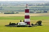
Happisburgh Lighthouse in Happisburgh
on the North Norfolk
coast is the only independently operated lighthouse
in Great Britain. It is also the oldest working lighthouse in East Anglia
.
The lighthouse is painted white with three red bands and has a light characteristic of Fl(3)30s (3 white flashes, repeated every 30 seconds) at a height of 135 ft (41.1 m) with a range of 14 miles (22.5 km).
at 134 ft (40.8 m) above sea level. The other lighthouse - the 'low light' which was decommissioned and demolished in 1883 before it could be lost due to coastal erosion - was 20 ft (6.1 m) lower. Together they formed a pair of range lights that marked a safe passage around the southern end of the offshore Haisborough Sands
8 miles (12.9 km) to the safe waters of 'The Would'.
and deactivation was planned for June 1988. Villagers organised a petition to oppose the closure, and as a result the date was postponed.
Under the Merchant Shipping Act of 1894, Trinity House may dispose of a working lighthouse only to an established Lighthouse Authority. On 25 April 1990 the Happisburgh Lighthouse Act received the Royal Assent establishing the Happisburgh Lighthouse Trust as a Local Light Authority, and Happisburgh became the only independently run operational lighthouse in Great Britain.
Happisburgh
Happisburgh is a village and civil parish in the English county of Norfolk. It is situated off the B1159 coast road from Ingham to Bacton.The civil parish has an area of , although this is declining due to cliff erosion. In the 2001 census, before the creation of Walcott parish, it had a...
on the North Norfolk
North Norfolk
North Norfolk is a local government district in Norfolk, United Kingdom. Its council is based in Cromer. The council headquarters can be found approximately out of the town of Cromer on the Holt Road.-History:...
coast is the only independently operated lighthouse
Lighthouse
A lighthouse is a tower, building, or other type of structure designed to emit light from a system of lamps and lenses or, in older times, from a fire, and used as an aid to navigation for maritime pilots at sea or on inland waterways....
in Great Britain. It is also the oldest working lighthouse in East Anglia
East Anglia
East Anglia is a traditional name for a region of eastern England, named after an ancient Anglo-Saxon kingdom, the Kingdom of the East Angles. The Angles took their name from their homeland Angeln, in northern Germany. East Anglia initially consisted of Norfolk and Suffolk, but upon the marriage of...
.
The lighthouse is painted white with three red bands and has a light characteristic of Fl(3)30s (3 white flashes, repeated every 30 seconds) at a height of 135 ft (41.1 m) with a range of 14 miles (22.5 km).
History
The existing building was constructed in 1790, originally as one of a pair of candle-powered lights ("High Lighthouse" and "Low Lighthouse") and has been electrified since 1947. The tower is 85 ft (25.9 m) tall, putting the lanternLantern
A lantern is a portable lighting device or mounted light fixture used to illuminate broad areas. Lanterns may also be used for signaling, as 'torches', or as general light sources outdoors . Low light level varieties are used for decoration. The term "lantern" is also used more generically to...
at 134 ft (40.8 m) above sea level. The other lighthouse - the 'low light' which was decommissioned and demolished in 1883 before it could be lost due to coastal erosion - was 20 ft (6.1 m) lower. Together they formed a pair of range lights that marked a safe passage around the southern end of the offshore Haisborough Sands
Haisborough Sands
Haisborough Sands is a sandbank off the coast of Norfolk, England at Happisburgh. The shoal is long and wide and lies parallel to the North east coast of Norfolk. The shoal is marked to the north-west by north by the Haisbro Light Buoy, North cardinal...
8 miles (12.9 km) to the safe waters of 'The Would'.
Independence
In 1987 Happisburgh was one of 5 lighthouses declared redundant by Trinity HouseTrinity House
The Corporation of Trinity House of Deptford Strond is the official General Lighthouse Authority for England, Wales and other British territorial waters...
and deactivation was planned for June 1988. Villagers organised a petition to oppose the closure, and as a result the date was postponed.
Under the Merchant Shipping Act of 1894, Trinity House may dispose of a working lighthouse only to an established Lighthouse Authority. On 25 April 1990 the Happisburgh Lighthouse Act received the Royal Assent establishing the Happisburgh Lighthouse Trust as a Local Light Authority, and Happisburgh became the only independently run operational lighthouse in Great Britain.
In popular culture
- Location of Ellie GouldingEllie GouldingElena Jane "Ellie" Goulding is an English singer-songwriter. In 2010 she became only the second artist to both top the BBC's annual Sound of... poll, and win the Critics' Choice Award at the BRIT Awards in the same year, following Adele's win of both in 2008...
's video for 2010 song The WriterThe Writer (song)"The Writer" is a song by English recording artist Ellie Goulding from her debut album, Lights. It was released as the album's fourth and final single on 8 August 2010.-Background:...
.
External links
- Happisburgh Lighthouse website
- Trinity House Lighthouse Service
- An 1892 OS map, showing both the Happisburgh lighthouses ('England - Norfolk: 030/NW', Ordnance Survey 1:10,560 - Epoch 1 (1892)). Date accessed: 28 August 2010