
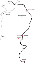
Hangers Way
Encyclopedia
Hangers Way is a 21 mile long-distance footpath
through Hampshire
, England
from Alton
railway station to Queen Elizabeth Country Park
.
The name Hanger comes from the Old English word hangra, meaning a steeply wooded slope.
The footpath passes through Petersfield
and Selborne
along a series of steep-sided wooded hills, known as “The Hangers”, and can be walked in either direction.
The footpath is waymarked
by metal and plastic disks found attached to wooden and metal posts, trees and street furniture. The waymarks are green and show a slope with a single tree.
Trail
A trail is a path with a rough beaten or dirt/stone surface used for travel. Trails may be for use only by walkers and in some places are the main access route to remote settlements...
through Hampshire
Hampshire
Hampshire is a county on the southern coast of England in the United Kingdom. The county town of Hampshire is Winchester, a historic cathedral city that was once the capital of England. Hampshire is notable for housing the original birthplaces of the Royal Navy, British Army, and Royal Air Force...
, England
England
England is a country that is part of the United Kingdom. It shares land borders with Scotland to the north and Wales to the west; the Irish Sea is to the north west, the Celtic Sea to the south west, with the North Sea to the east and the English Channel to the south separating it from continental...
from Alton
Alton, Hampshire
Alton is a historic market town and civil parish in the East Hampshire district of the English county of Hampshire. It had a population of 16,584 at the 1991 census and is administered by East Hampshire district council. It is located on the source of the River Wey and is the highest town in...
railway station to Queen Elizabeth Country Park
Queen Elizabeth Country Park
Queen Elizabeth Country Park is a large country park situated on the South Downs in southern England. It is located on the A3 road three miles south of Petersfield, Hampshire....
.
The name Hanger comes from the Old English word hangra, meaning a steeply wooded slope.
The footpath passes through Petersfield
Petersfield, Hampshire
Petersfield is a market town and civil parish in the East Hampshire district of Hampshire, England. It is north of Portsmouth, on the A3 road. The town has its own railway station on the Portsmouth Direct Line, the mainline rail link connecting Portsmouth and London. The town is situated on the...
and Selborne
Selborne
Selborne is a village in the East Hampshire district of Hampshire, England. It is south of Alton. It will be just within the extreme northern boundary of the proposed South Downs National Park, which is due to take effect in mid-2010....
along a series of steep-sided wooded hills, known as “The Hangers”, and can be walked in either direction.
The footpath is waymarked
Waymarking
Waymarking is an activity where people locate and log interesting locations around the world, usually with a GPS receiver and a digital camera. Waymarking differs from geocaching in that there is no physical container to locate at the given coordinates. Waymarking identifies points of interest for...
by metal and plastic disks found attached to wooden and metal posts, trees and street furniture. The waymarks are green and show a slope with a single tree.
The route
These maps show the footpath in relation to nearby major roads and towns. |  |