
HM Fort Roughs
Encyclopedia
World War II
World War II, or the Second World War , was a global conflict lasting from 1939 to 1945, involving most of the world's nations—including all of the great powers—eventually forming two opposing military alliances: the Allies and the Axis...
installations, that were designed by Guy Maunsell
Guy Maunsell
Guy Anson Maunsell was the British civil engineer responsible for the design of the World War II Naval Sea Forts and Army Forts used by the United Kingdom for the defence of the Thames and Mersey estuaries....
and known collectively as His Majesty's Forts or as Maunsell Sea Forts, and its purpose was to guard the port of Harwich
Harwich
Harwich is a town in Essex, England and one of the Haven ports, located on the coast with the North Sea to the east. It is in the Tendring district. Nearby places include Felixstowe to the northeast, Ipswich to the northwest, Colchester to the southwest and Clacton-on-Sea to the south...
, Essex
Essex
Essex is a ceremonial and non-metropolitan county in the East region of England, and one of the home counties. It is located to the northeast of Greater London. It borders with Cambridgeshire and Suffolk to the north, Hertfordshire to the west, Kent to the South and London to the south west...
. The naval fort is situated on Rough Sands, a sandbar located approximately six miles from the coast of Suffolk
Suffolk
Suffolk is a non-metropolitan county of historic origin in East Anglia, England. It has borders with Norfolk to the north, Cambridgeshire to the west and Essex to the south. The North Sea lies to the east...
and eight miles from the coast of Essex
Essex
Essex is a ceremonial and non-metropolitan county in the East region of England, and one of the home counties. It is located to the northeast of Greater London. It borders with Cambridgeshire and Suffolk to the north, Hertfordshire to the west, Kent to the South and London to the south west...
.
It later became a self-proclaimed, unrecognised state called the Principality of Sealand
Principality of Sealand
The Principality of Sealand is an unrecognized entity, located on HM Fort Roughs, a former World War II Maunsell Sea Fort in the North Sea 10 km off the coast of Suffolk, England, United Kingdom ....
. It is the de facto capital of Sealand and has a claimed population of 27 (which is the whole population of Sealand).
1943: Dry dock construction
Pontoon (boat)
A pontoon is a flotation device with buoyancy sufficient to float itself as well as a heavy load. A pontoon boat is a flattish boat that relies on pontoons to float. Pontoons may be used on boats, rafts, barges, docks, floatplanes or seaplanes. Pontoons may support a platform, creating a raft. A...
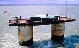
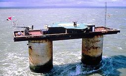
base with a superstructure of two hollow towers joined by a deck upon which other structures could be added. The pontoon was reinforced concrete measuring 168 by 88 feet. The fort was topped by a gun deck, an upper deck and a central tower unit which housed the radar equipment. The twin towers were divided into seven floors that provided dining and sleeping accommodation and storage areas for generators and munitions. There was a steel framework at one end supporting a landing jetty and crane which was used to hoist supplies aboard. Electricity needs were met by several generators
Electrical generator
In electricity generation, an electric generator is a device that converts mechanical energy to electrical energy. A generator forces electric charge to flow through an external electrical circuit. It is analogous to a water pump, which causes water to flow...
.
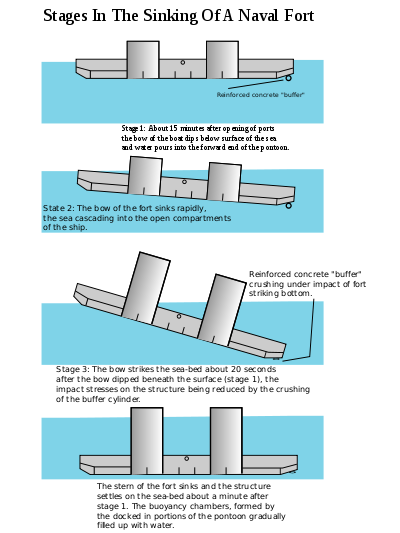
On 11 February 1943 the fort was towed by three tugs to a location on Rough Sands where its base was intentionally flooded so that it sank to a resting place on the sandbar. At that time Rough Sands were situated in international waters. The superstructure of the vessel above the waterline remained visible from the coastline of England.
HMS Roughs was in operation within 30 minutes of being launched. The crew had been aboard during the fitting out in harbour and were well acquainted with the fort's equipment. Approximately 100 men were assigned to the barge before deployment on Rough Sands, and the facility was occupied by 150-300 Royal Navy personnel throughout WWII. At the conclusion of hostilities all original personnel were evacuated from HMS Fort Rough. The armament consisted of 3.75 inch AA guns and Bofors 40 mm guns - the standard medium and light anti-aircraft weaponry of the British and Commonwealth forces.
1956: Removal of full-time HMG personnel from Roughs Tower
British government official entities used Roughs Tower for a variety of purposes until 1956 when all full-time personnel were finally removed. Roughs Tower remained identified by name on buoys placed in position by the Ministry of DefenceMinistry of Defence (United Kingdom)
The Ministry of Defence is the United Kingdom government department responsible for implementation of government defence policy and is the headquarters of the British Armed Forces....
which are maintained under an arrangement with Trinity House
Trinity House
The Corporation of Trinity House of Deptford Strond is the official General Lighthouse Authority for England, Wales and other British territorial waters...
. Their purpose is to warn vessels of this obstacle, especially in time of fog because busy shipping lanes criss-crossed the area with vessels going to and from the container Port of Felixstowe
Felixstowe
Felixstowe is a seaside town on the North Sea coast of Suffolk, England. The town gives its name to the nearby Port of Felixstowe, which is the largest container port in the United Kingdom and is owned by Hutchinson Ports UK...
, Suffolk
Suffolk
Suffolk is a non-metropolitan county of historic origin in East Anglia, England. It has borders with Norfolk to the north, Cambridgeshire to the west and Essex to the south. The North Sea lies to the east...
, and the Port of Harwich, Essex. UK Ordnance Survey
Ordnance Survey
Ordnance Survey , an executive agency and non-ministerial government department of the Government of the United Kingdom, is the national mapping agency for Great Britain, producing maps of Great Britain , and one of the world's largest producers of maps.The name reflects its creation together with...
now identify the former sea barge fort as Roughs Tower on their charts.
1966: Occupation
In 1966 Paddy Roy BatesPaddy Roy Bates
- Titles and styles :*2 September 1967–present: His Royal Highness the Prince of Sealand- Full title as Prince :His Royal Highness Roy Bates, Prince of Sealand- References :...
, who operated Radio Essex, and Ronan O'Rahilly
Ronan O'Rahilly
Ronan O'Rahilly is an Irish businessman best known for the creation of the offshore radio station, Radio Caroline.O'Rahilly's parents owned the private port of Greenore in Carlingford Lough, County Louth...
, who operated Radio Caroline
Radio Caroline
Radio Caroline is an English radio station founded in 1964 by Ronan O'Rahilly to circumvent the record companies' control of popular music broadcasting in the United Kingdom and the BBC's radio broadcasting monopoly...
, landed on Fort Roughs and occupied it. However, after disagreements, Roy Bates seized the tower as his own. O'Rahilly attempted to storm the fort in 1967, but Roy Bates defended the fort with guns and petrol bombs and continued to occupy the fort. The British Royal Marines went on alert and the British Authorities ordered Roy Bates to surrender. In his refusal, Roy Bates founded the Principality of Sealand
Principality of Sealand
The Principality of Sealand is an unrecognized entity, located on HM Fort Roughs, a former World War II Maunsell Sea Fort in the North Sea 10 km off the coast of Suffolk, England, United Kingdom ....
on 2 September 1967.
Location
Bob Le-Roi's Fort Fanatics webpage stated on 28 Sep 2011 that modern charts (not available online) using the WGS84 coordinatesWorld Geodetic System
The World Geodetic System is a standard for use in cartography, geodesy, and navigation. It comprises a standard coordinate frame for the Earth, a standard spheroidal reference surface for raw altitude data, and a gravitational equipotential surface that defines the nominal sea level.The latest...
normally used for GPS, showed the fort at 51°53.71′N 1°28.83′E (ie 51°53′42.6″N 1°28′49.8″E). Maritime charts are normally considered more authoritative than land maps for location of maritime obstructions, so those coordinates are chosen for this article. The fort can also be found online on UK government Ordnance Survey
Ordnance Survey
Ordnance Survey , an executive agency and non-ministerial government department of the Government of the United Kingdom, is the national mapping agency for Great Britain, producing maps of Great Britain , and one of the world's largest producers of maps.The name reflects its creation together with...
maps at grid reference TM3964227615, within 100 m, and on OpenStreetMap within 200 m, of the chart location 51°53′42.6"N 1°28′49.8"E. OpenStreetMap notes that the structure includes a helipad
Helipad
Helipad is a common abbreviation for helicopter landing pad, a landing area for helicopters. While helicopters are able to operate on a variety of relatively flat surfaces, a fabricated helipad provides a clearly marked hard surface away from obstacles where a helicopter can safely...
.
The structure does not appear in the aerial views on Bing Maps, Google Maps or Google Earth. However, neither do the adjacent (somewhat larger) sandbanks at Rough Sands and Cork Sand, or the marker buoys for them. Those photographic services do not guarantee to include items remote from land. Generic "sea" photos may have been used.