
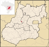
Guaraíta
Encyclopedia
| Guaraíta | |
|---|---|
| State | Goiás Goiás Goiás is a state of Brazil, located in the central part of the country. The name Goiás comes from the name of an indigenous community... |
| Area: | 205 km² |
| Population: | 2,394 (IBGE 2007) |
| Elevation: | 669 m above sea level |
| Postcode (CEP): | 76690-000 |
| Became a city: | 1992 |
| Microregion: | Ceres Ceres Microregion The Ceres Microregion is located in north-central Goiás state, Brazil. It includes 22 cities with a total population of 215,820 inhabitants . The total area is 13,224.40 km² and the population density is 16.32 inhab/km². The most important cities are Ceres and Goianésia.The most populous... |
| Mayor: | Célia de Morais Marques |
| Distance to Goiânia Goiânia -Climate:The city has a tropical wet and dry climate with an average temperature of . There's a wet season, from October to April, and a dry one, from May to September. Annual rainfall is around 1,520 mm.... : |
184 km |
| Website: | none |
Town
A town is a human settlement larger than a village but smaller than a city. The size a settlement must be in order to be called a "town" varies considerably in different parts of the world, so that, for example, many American "small towns" seem to British people to be no more than villages, while...
and municipality
Municipality
A municipality is essentially an urban administrative division having corporate status and usually powers of self-government. It can also be used to mean the governing body of a municipality. A municipality is a general-purpose administrative subdivision, as opposed to a special-purpose district...
in central Goiás
Goiás
Goiás is a state of Brazil, located in the central part of the country. The name Goiás comes from the name of an indigenous community...
state, Brazil
Brazil
Brazil , officially the Federative Republic of Brazil , is the largest country in South America. It is the world's fifth largest country, both by geographical area and by population with over 192 million people...
.
Location
It is included in the Ceres MicroregionCeres Microregion
The Ceres Microregion is located in north-central Goiás state, Brazil. It includes 22 cities with a total population of 215,820 inhabitants . The total area is 13,224.40 km² and the population density is 16.32 inhab/km². The most important cities are Ceres and Goianésia.The most populous...
and is bordered on the north and east by the municipalities of Itapuranga
Itapuranga
Itapuranga is a small town and municipality in northern Goiás state, Brazil.-Location and Climate:Itapuranga is located northwest of Goiânia and north of Goiás, the old capital of the state....
and on the west and south by Goiás
Goiás, Goiás
Goiás is a small city and municipality in the state of Goiás in Brazil. The population was 24,072 in a total area of 3,108 km² . It is the former capital of the state and preserves much of its colonial heritage...
.
Highway connections from Goiânia
Goiânia
-Climate:The city has a tropical wet and dry climate with an average temperature of . There's a wet season, from October to April, and a dry one, from May to September. Annual rainfall is around 1,520 mm....
are made by GO-070 / Goianira
Goianira
Goianira is a small city and municipality in central Goiás state, Brazil, located 32 kilometers northwest of the state capital, Goiânia. The population was 24,110 in a total area of 200.4 km² . Goianira is becoming a major producer of shoes.Goianira is four kilometers east of highway BR-457 /...
/ Itaberaí
Itaberaí
Itaberaí is a small city and municipality in central Goiás state, Brazil. Itaberaí is a large producer of agricultural products including corn, rice, soybeans, tomatoes, and sugarcane.-Location:...
/ GO-156 / Itapuranga
Itapuranga
Itapuranga is a small town and municipality in northern Goiás state, Brazil.-Location and Climate:Itapuranga is located northwest of Goiânia and north of Goiás, the old capital of the state....
/ GO-525. See Seplan. The nearest major city is Goiás
Goiás, Goiás
Goiás is a small city and municipality in the state of Goiás in Brazil. The population was 24,072 in a total area of 3,108 km² . It is the former capital of the state and preserves much of its colonial heritage...
, 35 km. away.
Demographics
The population has been decreasing since 1980. The urban population is slightly larger than the rural population:- Urban population in 2007: 1,478
- Rural population in 2007: 916
The economy
The economy is based on agriculture (rice, beans, manioc, corn, and bananas), and cattle raising (20,200 head in 2006. There were 14 retail establishments. There were 325 farms in 2006 with a total area of 15,285 hectares, of which 600 hectares were cropland. There were 109 automobiles in 2007.Health and education
The literacy rate was 82.9% in 2000 while the infant mortality rate was 33.15 in 1,000 live births. There were only 2 schools with 718 students (2006). There were no hospitals and only 4 doctors.Rating on the Municipal Human Development Index
Human Development Index
The Human Development Index is a composite statistic used to rank countries by level of "human development" and separate "very high human development", "high human development", "medium human development", and "low human development" countries...
- MHDI: 0.697
- State ranking: 210 (out of 242 municipalities in 2000)
- National ranking: 3,039 (out of 5,507 municipalities in 2000)
For the complete list see frigoletto.com.br
Sources of Data
See also
List of municipalities in Goiás