
Großer Beerberg
Encyclopedia
The Grosser Beerberg is a mountain
located in the Thuringian Forest
, Germany
and the highest point in Thuringia
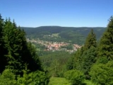
. The nearest town is Suhl
, in Ilm-Kreis
.
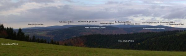
Between Beerberg's summit and that of its eastern neighbor, Schneekopf (978 m), the second highest mountain of Thuringia, is a 60 m deep col
. To the west is Sommerbachskopf (941 m).
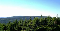
On the summit of Beerberg is one of the few moorland
s of the Thüringer Wald. Until the end of the 1980s there was an observation tower on the mountain. A few years ago a small platform was again established below the summit at Plänckners Aussicht, which offers an outstanding view to the south and southwest.
The section of the Rennsteig
walkway between Oberhof
and Schmücke
runs across the mountain.
Mountain
Image:Himalaya_annotated.jpg|thumb|right|The Himalayan mountain range with Mount Everestrect 58 14 160 49 Chomo Lonzorect 200 28 335 52 Makalurect 378 24 566 45 Mount Everestrect 188 581 920 656 Tibetan Plateaurect 250 406 340 427 Rong River...
located in the Thuringian Forest
Thuringian Forest
The Thuringian Forest running northwest to southeast, forms a continuous stretch of ancient rounded mountains posing ample difficulties in transit routing save through a few navigable passes in the southern reaches of the German state of Thuringia. It is about long and wide...
, Germany
Germany
Germany , officially the Federal Republic of Germany , is a federal parliamentary republic in Europe. The country consists of 16 states while the capital and largest city is Berlin. Germany covers an area of 357,021 km2 and has a largely temperate seasonal climate...
and the highest point in Thuringia
Thuringia
The Free State of Thuringia is a state of Germany, located in the central part of the country.It has an area of and 2.29 million inhabitants, making it the sixth smallest by area and the fifth smallest by population of Germany's sixteen states....
. The nearest town is Suhl
Suhl
- Geography :Suhl sits on the south edge of the Suhler Scholle, an upthrust granite complex that is streaked by numerous dikes. This is part of the Ruhla-Schleusingen Horst that defines the southwest side of the Thuringian Forest...
, in Ilm-Kreis
Ilm-Kreis
Ilm-Kreis is a district in Thuringia, Germany. It is bounded by the city of Erfurt, the districts of Weimarer Land, Saalfeld-Rudolstadt and Hildburghausen, the city of Suhl, and the districts of Schmalkalden-Meiningen and Gotha...
.
Between Beerberg's summit and that of its eastern neighbor, Schneekopf (978 m), the second highest mountain of Thuringia, is a 60 m deep col
Mountain pass
A mountain pass is a route through a mountain range or over a ridge. If following the lowest possible route, a pass is locally the highest point on that route...
. To the west is Sommerbachskopf (941 m).
On the summit of Beerberg is one of the few moorland
Moorland
Moorland or moor is a type of habitat, in the temperate grasslands, savannas, and shrublands biome, found in upland areas, characterised by low-growing vegetation on acidic soils and heavy fog...
s of the Thüringer Wald. Until the end of the 1980s there was an observation tower on the mountain. A few years ago a small platform was again established below the summit at Plänckners Aussicht, which offers an outstanding view to the south and southwest.
The section of the Rennsteig
Rennsteig
The Rennsteig is a ridge walk as well as an historical boundary path in the Thuringian Forest, Thuringian Highland and Franconian Forest in central Germany....
walkway between Oberhof
Oberhof, Germany
Oberhof is a town in the Schmalkalden-Meiningen district of Thuringia, Germany. It is a winter sports center and health resort. It is visited by tenfold as many tourists every year...
and Schmücke
Schmücke
- Geography :Together with the Hohe Schrecke, the Finne and the Hainleite, the Schmücke borders the northern rim of the Thuringian Basin. It lies between Hauteroda, Oberheldrungen, Heldrungen, Heldrungen station, Gorsleben and Hemleben...
runs across the mountain.
External links