

Ground penetrating radar survey (archaeology)
Encyclopedia
Ground penetrating radar (GPR) survey is one of a number of methods used in archaeological geophysics. GPR can be used to detect and map subsurface archaeological artifacts
, features
, and patterning.
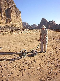 The concept of radar is familiar to most people. With ground penetrating radar, the radar signal – an electromagnetic pulse – is directed into the ground. Subsurface objects and stratigraphy (layering) will cause reflections that are picked up by a receiver. The travel time
of the reflected signal indicates the depth. Data may be plotted as profiles, as planview maps isolating specific depths, or as three-dimensional models.
GPR can be a powerful tool in favorable conditions (uniform sandy soils are ideal). Like other geophyscal methods used in archaeology (and unlike excavation) it can locate artifacts
and map features
without any risk of damaging them. Among methods used in archaeological geophysics it is unique both in its ability to detect some spatially small objects at relatively great depths and in its ability to distinguish the depth of anomaly sources. The principal disadvantage of GPR is that it is severely limited by less-than-ideal environmental conditions. Fine-grained sediments (clays and silts) are often problematic because their high electrical conductivity causes loss of signal strength; rocky or heterogeneous sediments scatter the GPR signal, weakening the useful signal while increasing extraneous noise.
Individual lines of GPR data represent a sectional (profile) view of the subsurface. Multiple lines of data systematically collected over an area may be used to construct three-dimensional or tomographic
images. Data may be presented as three-dimensional blocks, or as horizontal or vertical slices. Horizontal slices (known as "depth slices" or "time slices") are essentially planview maps isolating specific depths. Time-slicing has become standard practice in archaeological applications, because horizontal patterning is often the most important indicator of cultural activities.
Artifact (archaeology)
An artifact or artefact is "something made or given shape by man, such as a tool or a work of art, esp an object of archaeological interest"...
, features
Feature (archaeology)
Feature in archaeology and especially excavation has several different but allied meanings. A feature is a collection of one or more contexts representing some human non-portable activity that generally has a vertical characteristic to it in relation to site stratigraphy. Examples of features are...
, and patterning.
Overview
Travel time
Travel time may refer to* Travel, movement of people between locations* Travel journal, record made by a voyager* Propagation speed, term in physics to measure things such as the speed of light or radio waves...
of the reflected signal indicates the depth. Data may be plotted as profiles, as planview maps isolating specific depths, or as three-dimensional models.
GPR can be a powerful tool in favorable conditions (uniform sandy soils are ideal). Like other geophyscal methods used in archaeology (and unlike excavation) it can locate artifacts
Artifact (archaeology)
An artifact or artefact is "something made or given shape by man, such as a tool or a work of art, esp an object of archaeological interest"...
and map features
Feature (archaeology)
Feature in archaeology and especially excavation has several different but allied meanings. A feature is a collection of one or more contexts representing some human non-portable activity that generally has a vertical characteristic to it in relation to site stratigraphy. Examples of features are...
without any risk of damaging them. Among methods used in archaeological geophysics it is unique both in its ability to detect some spatially small objects at relatively great depths and in its ability to distinguish the depth of anomaly sources. The principal disadvantage of GPR is that it is severely limited by less-than-ideal environmental conditions. Fine-grained sediments (clays and silts) are often problematic because their high electrical conductivity causes loss of signal strength; rocky or heterogeneous sediments scatter the GPR signal, weakening the useful signal while increasing extraneous noise.
Individual lines of GPR data represent a sectional (profile) view of the subsurface. Multiple lines of data systematically collected over an area may be used to construct three-dimensional or tomographic
Tomography
Tomography refers to imaging by sections or sectioning, through the use of any kind of penetrating wave. A device used in tomography is called a tomograph, while the image produced is a tomogram. The method is used in radiology, archaeology, biology, geophysics, oceanography, materials science,...
images. Data may be presented as three-dimensional blocks, or as horizontal or vertical slices. Horizontal slices (known as "depth slices" or "time slices") are essentially planview maps isolating specific depths. Time-slicing has become standard practice in archaeological applications, because horizontal patterning is often the most important indicator of cultural activities.