
Grimsay
Encyclopedia

Island
An island or isle is any piece of sub-continental land that is surrounded by water. Very small islands such as emergent land features on atolls can be called islets, cays or keys. An island in a river or lake may be called an eyot , or holm...
in the Outer Hebrides
Outer Hebrides
The Outer Hebrides also known as the Western Isles and the Long Island, is an island chain off the west coast of Scotland. The islands are geographically contiguous with Comhairle nan Eilean Siar, one of the 32 unitary council areas of Scotland...
of Scotland
Scotland
Scotland is a country that is part of the United Kingdom. Occupying the northern third of the island of Great Britain, it shares a border with England to the south and is bounded by the North Sea to the east, the Atlantic Ocean to the north and west, and the North Channel and Irish Sea to the...
.
Grimsay is the largest of the low-lying stepping-stones which convey the Oitir Mhòr (North Ford) causeway, a five mile arc of single track road linking North Uist
North Uist
North Uist is an island and community in the Outer Hebrides of Scotland.-Geography:North Uist is the tenth largest Scottish island and the thirteenth largest island surrounding Great Britain. It has an area of , slightly smaller than South Uist. North Uist is connected by causeways to Benbecula...
and Benbecula
Benbecula
Benbecula is an island of the Outer Hebrides in the Atlantic Ocean off the west coast of Scotland. In the 2001 census it had a usually resident population of 1,249, with a sizable percentage of Roman Catholics. It forms part of the area administered by Comhairle nan Eilean Siar or the Western...
via the western tip of Grimsay. Until it opened in 1960, a ferry linked Carinish
Carinish
Carinish , in North Uist, in the Western Isles of Scotland, is known for the Carinish Stone Circle and the Trinity Temple.-Carinish Stone Circle:Carinish Stone Circle is not in a good condition - it has a main road running almost through the middle of it...
(on North Uist) with Gramisdale (on Benbecula), but could only operate at high tide. There was also a ford which could only be crossed close to low water, usually only with a guide. For significant parts of each day the North Ford was too wet to ford and not wet enough to cross by ferry. East of Grimsay lie several smaller islands including Ronay
Ronay
Ronay is an island in the Outer Hebrides of Scotland, which lies a short distance off the east coast of Grimsay.-Geography:Ronay has a highly indented coastline with Bàgh nan Uamh being the biggest up in the north west...
which was inhabited until the 1920s.
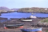
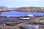
The main settlements are Baymore (Bàgh Mòr) and Kallin (Ceallan) at the eastern end of the island. Grimsay has a harbour at Kallin, which is the base to a sizeable shellfish industry, the island's main industry, mostly for lobster, prawns and scallops. Also in Kallin is The Boatshed, a marine repair facility which promotes traditional skills and includes a museum. Boat building
Boat building
Boat building, one of the oldest branches of engineering, is concerned with constructing the hulls of boats and, for sailboats, the masts, spars and rigging.-Parts:* Bow - the front and generally sharp end of the hull...
was previously important. Grimsay is encircled by a single-track road that links most of the island's small croft and fishing settlements together.
There is a fine example of an Iron-Age wheelhouse
Wheelhouse (archaeology)
In archaeology, a wheelhouse is a prehistoric structure from the Iron Age found in Scotland. The term was first coined after the discovery of a ruined mound in 1855. The distinctive architectural form related to the complex roundhouses, constitute the main settlement type in the Western Isles, in...
on the northeast coast of the island at Bagh nam Feadag (The Grimsay Wheelhouse).