

Grianan of Aileach
Encyclopedia
County Donegal
County Donegal is a county in Ireland. It is part of the Border Region and is also located in the province of Ulster. It is named after the town of Donegal. Donegal County Council is the local authority for the county...
, Ireland
Republic of Ireland
Ireland , described as the Republic of Ireland , is a sovereign state in Europe occupying approximately five-sixths of the island of the same name. Its capital is Dublin. Ireland, which had a population of 4.58 million in 2011, is a constitutional republic governed as a parliamentary democracy,...
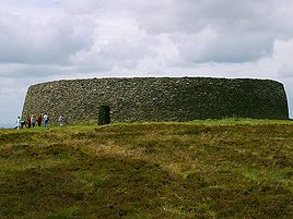
built on the hill of Grianán which is 244 metres high. Most writers have identified the site as being the great “royal fort” of Aileach. The main structure is that of an ringfort
Ringfort
Ringforts are circular fortified settlements that were mostly built during the Iron Age , although some were built as late as the Early Middle Ages . They are found in Northern Europe, especially in Ireland...
built by the Uí Néill
Uí Néill
The Uí Néill are Irish and Scottish dynasties who claim descent from Niall Noigiallach , an historical King of Tara who died about 405....
in the sixth or seventh century in the early christian period
Christianity in Ireland
Christianity is and has been the largest religion in Ireland, both in the Republic of Ireland and Northern Ireland. Irish Christianity is dominated by the Roman Catholic Church which has 86.8% of the Republic's population as followers. Most churches are organized on an all-Ireland basis which...
It is generally accepted to be the seat of the Kingdom of Aileach
Kings of Ailech
The Kings of Ailech belonged to the northern Uí Néill and took their name from the Grianán of Ailech , a hillfort on top of Greenan Mountain in modern County Donegal...
although the true capital is now believed to lie further to the east. The kingdoms of Ulaidh and Kingdom of Oirialla were two subject kingdoms in the North under the general rule of Aileach. Whatever its true status, the Grianán was a historical centre of culture and politics during the rule of early Irish chieftains (c. 800 BCE-1200 CE).
An Irish creation myth claims that this fortress was built by the great king Daghda of Tuatha de Danann
Tuatha Dé Danann
The Tuatha Dé Danann are a race of people in Irish mythology. In the invasions tradition which begins with the Lebor Gabála Érenn, they are the fifth group to settle Ireland, conquering the island from the Fir Bolg....
. The grave of the king's son Aeah was in the centre of the fortress, which had been built around it. Whether such a grave existed is unknown; there are no archaeological remains, although a nearby tumulus could be a grave marker.
By the 12th century, the Kingdom of Aileach had become embattled and lost a fair amount of territory to the invading Normans. The fortress itself was destroyed by Muirchertach Ua Briain, King of Munster in 1101. By around 1177, the Normans controlled large portions of lands once held by Aileach.
Description and Interpretation
The Grianán is located on the western edge of a small group of hills that lie between the upper reaches of Lough SwillyLough Swilly
Lough Swilly in Ireland is a glacial fjord or sea inlet lying between the western side of the Inishowen Peninsula and the Fanad Peninsula, in County Donegal. Along with Carlingford Lough and Killary Harbour it is one of three known glacial fjords in Ireland....
and Lough Foyle
Lough Foyle
Lough Foyle, sometimes Loch Foyle , is the estuary of the River Foyle in Ulster. It starts where the Foyle leaves Derry. It separates the Inishowen Peninsula in County Donegal, Republic of Ireland from County Londonderry in Northern Ireland.-Transport:...
. Although the hill is comparatively not that high, the summit dominates the neighbouring counties of Londonderry
County Londonderry
The place name Derry is an anglicisation of the old Irish Daire meaning oak-grove or oak-wood. As with the city, its name is subject to the Derry/Londonderry name dispute, with the form Derry preferred by nationalists and Londonderry preferred by unionists...
, Donegal
Donegal
Donegal or Donegal Town is a town in County Donegal, Ireland. Its name, which was historically written in English as Dunnagall or Dunagall, translates from Irish as "stronghold of the foreigners" ....
and Tyrone
County Tyrone
Historically Tyrone stretched as far north as Lough Foyle, and comprised part of modern day County Londonderry east of the River Foyle. The majority of County Londonderry was carved out of Tyrone between 1610-1620 when that land went to the Guilds of London to set up profit making schemes based on...
. Located at the edge of the Inishowen
Inishowen
Inishowen is a peninsula in County Donegal, part of the Province of Ulster in the north of Ireland. It is also the largest peninsula in all of Ireland. Inishowen is a picturesque location with a rich history...
peninsula, it is 11.25 kilometres northwest of the ecclesiastical site of Derry
Derry
Derry or Londonderry is the second-biggest city in Northern Ireland and the fourth-biggest city on the island of Ireland. The name Derry is an anglicisation of the Irish name Doire or Doire Cholmcille meaning "oak-wood of Colmcille"...
. Both sites histories are closely linked. There is much legend and historical material related to the Grianán of Aileach. The Irish annals record its destruction in 1101. The main monument on the hill is a stone cashel, restored in the nineteenth century, but probably built in the eighth century AD. The summit’s use as an area of settlement may go back much further. A tumulus
Tumulus
A tumulus is a mound of earth and stones raised over a grave or graves. Tumuli are also known as barrows, burial mounds, Hügelgrab or kurgans, and can be found throughout much of the world. A tumulus composed largely or entirely of stones is usually referred to as a cairn...
at the Grianán may date back to Neolithic age and a covered well was found nearby the cashel in the early nineteenth century.
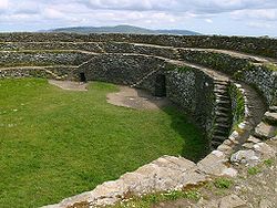
The ruins of the cashel itself are described as being a circular wall enclosing an area of 23.6 metres (77 ft 6 in) in diameter. The wall had a height of 1.8 metres (6 ft) with a breadth varying from 4.6 metres (15 ft) to 3.5 metres (11 ft 6 in). While not perpendicular, it had an inclination inwards indicating its similarity to most other Irish stone forts. Petrie suggests that it was probably originally between twice and four times as high as it was when he surveyed it. 1.5 metres (5 ft) up on the interior side of the wall, the thickness was 0.76 metres (2 ft 6 in) due to the presence of terracing. The terrace is reached by flights of steps on either side of the entrance gateway. Fallen stones had covered any other existing stairs. Petrie suggests that there were originally three or four such terraces ascending to the top of the wall. On each side of the entranceway, there are “galleries” within the wall. Their precise purpose is not clear and they do not connect with the entrance. These two wall-passages, one on the south and another from the northeast run towards the gateway, but stop short. Near the north end of the south passage is a small recess in its west wall. At the south end of the north passage there is a seat-stone.
The current hillfort, after the restoration of 1874-1878, is substantially different but much of the old structure remains intact. During the restoration, it was found that parts of the original drystone masonry had been preserved under the collapse. The workers marked, in tar, the undisturbed portions of the cashel and used the collapsed stone to build on this foundation. They supplemented these with other stones from the area to replace those ‘removed by King Murdoch O’Brien in 1101’. The internal diameters of the cashel are 23.6 metres north to south and 23.2 metres east to west. The lintel-covered entrance is 4.65 metres long, 1.12 metres wide and 1.86 metres high. Before the restoration, the gateway’s lintel was not in place. It was 1.3 metres (4 ft 3 in) wide and 1.2 metres (4 ft 2 in) high. It leads into the fort from the east. Slight recesses on either side of the entrance way have been filled in. They were probably to allow double leaves of an original doorway to fold flush against the wall. The interior rises in three terraces accessible by stairways which are previously mentioned. The outer wall is a dry-stone construction. On each side of the entranceway, there are “galleries” within the wall. Their precise purpose is not clear and they do not connect with the entrance. These two wall-passages, one on the south and another from the northeast run towards the gateway, but stop short. The south wall passage entrance is 45 centimetres wide, 60 centimetres high and 1.4 metres long. It turns through a right angle where it becomes 50 centimetres wide, 85 centimetres high and 20.4 metres long. Near the north end there is a recess on the west side 50 centimetres wide, 1 metre high and 75 centimetres deep. The northeast gallery entrance is 65 centimetres wide, 97 centimetres high and 1.55 metres long. It meets the main part of the passage in a T-junction. To the north, the passage is 70 centimetres wide, 1.3 metres high and 2.5 metres long. To the south, the passage is 60 centimetres wide, 1.4 metres high and 8.6 metres long. Near the north of end of the south passage is a small recess in its west wall. At the south end of the north passage there is a seat-stone. The interior of the cashel is fairly level but Petrie recorded the remains of a small oblong church measuring 5 metres (16 ft 6 in) by 4.3 metres (14 ft 3 in). The walls were 0.61 metres (2 ft) thick and not more than 0.61 metres (2 ft) high. The structure was constructed of mortar but nothing remains of it today. A drain runs through the cashel wall at ground level on the northwest side. It leads from a midden in the western side of the enclosure that was 1.7 metres (5 ft 5 in) in diameter and one foot deep.
As mentioned above, there are many clues that the Grianán of Aileach is a multi-period site. Brian Lacy suggests that the earthen banks surrounding the fort probably represent the defences of a hillfort of the late Bronze Age or Iron Age. Between the two outer banks on the south side of the hill, is the formerly covered spring well which is dedicated to St. Patrick. Petrie describes the tumulus, between the second and third wall, as being a small mound surrounded by a circle of ten stones. These stones were laid horizontally and converged towards the centre. In Petrie’s time, the mound had been excavated but nothing to explain its meaning was discovered. It was subsequently destroyed but its former position is marked by a heap of broken stones.
During the excavation work of the 1870s, Bernard documents the discovery of many artefacts. Behind a niche in the doorway, a large stone (0.4 metres (16 in) wide) was found. It had a round hole in the centre, 7.6 centimetres (3 in) deep and 3.8 centimetres (1.5 in) in diameter. A rotten piece of wood was found in the hole. Bernard was unable to decipher its use suggesting only that it could have been a sundial.
Bernard discovered many animal bones including sheep, cattle, goats and birds. He found stone items including ‘sling-stones’, ‘warrior’s clubs’ and a ‘sugar-loaf-shaped stone with a well-cut base, 25 centimetres (10 in) long, 38 centimetres (15 in) round base, 36 centimetres (14 in) round centre and 25 centimetres (10 in) round top. The most interesting stone object was ‘a slab of sandstone, chequered into thirty-six squares’. Lacy believed it to be some kind of gaming board. Among the miscellaneous items found were a plough socket, an iron ring, some coins and a bead.
Morphology
The Grianán of Aileach, at its broadest description, is a ringfort. More precisely it is a multivallate cashel hillfort.A ring fort can be described as a space, usually circular, surrounded by a bank and fosse
Fosse
Fosse is a three-act musical revue showcasing the choreography of Bob Fosse. After 21 previews, the original Broadway production, conceived and directed by Richard Maltby, Jr...
or simply a rampart of stone. The bank is generally built by piling up inside the fosse the material obtained digging the latter. Ringforts vary considerably in size and style. In more elaborately defended examples, such as Aileach, the defences take up a much greater area than the enclosure itself.
Matthew Stout gives many examples of why the people who built these structures chose a circular formation. First of all, they had strategic advantages. Circular sites allowed for a broad perspective of the surrounding area and allowed the maximum area to be enclosed relative to the bank constructed. He also comes up with some much more metaphysical theories. He suggests that a circular formation linked the site and its occupants with the circular burial mounds of their ancestors. About a third of all Irish hillforts have mounds or cairns within them. The Aileach is no exception. He also puts forward the idea that a circular form was favoured because corners could act as a dwelling-place of evil spirits. He bases these claims on ethnographic comparisons.
Ringforts housed families of varying degrees of wealth, so that some of them are more impressive than others. Ringforts do not normally occupy dominant or commanding positions. The only exception to this are the ringforts built in areas of bad drainage where high places are the only suitable spots for habitation. Raftery names three monuments which he finds hard to categorise as being either a ringfort or a hillfort: Cahirciveen; Carraig Aille; and Lough Gur. While the places where they sit are areas of natural defence, they may have been built there for drainage purposes. The buildings themselves are not militaristic or defensive in themselves. They were probably family homesteads. The defining characteristic of hillforts is an inbuilt defensive nature.
Therefore, hillforts as a subcategory of the ringfort are defined by their location and style of construction. Hillfort consist of ‘large hilltop areas on which the summit is enclosed by one (univallate) or multiple ramparts (multivallate) of earth or stone’. A good example would be Dún Aengus
Dún Aengus
Dún Aonghasa is the most famous of several prehistoric forts on the Aran Islands, of County Galway, Ireland. It is located on Inishmore at the edge of an approximately 100 metre high cliff....
on Inishmore. Its defensive nature is explicit due to the system of stone slabs, known as chevaux de frise, planted into the ground outside the fort structure itself.
The Grianán of Aileach, as described in the introductory section, is encircled by three enclosures and is therefore trivallate. The actual living space of ringforts often forms less than 60% of the total monument area. Contemporary law tracts described a king’s principle dwelling to have been a univallate ringfort. Increasing a site’s defences without a corresponding increase in its functional area demonstrates either a greater need for defence or a display of status. Therefore, a ring fort with two ramparts (bivallate) acts a status symbol. The rarity of trivallate hillforts, such as that at the Grianán, shows the importance and status of its occupants rather a need for defence.
Stout gives several examples to indicate their symbolic importance simply due to their impracticality as defensive structures. In general, they were little more than fences to prevent stock from straying and to protect against wild animals. As siege tools, they were useless. If anything they were built to repel cattle raids.This might not be the case with the Grianán of Aileach
While the original structure for which the ramparts were built does not exist anymore, the cashel of Aileach, while formidable, was probably designed with less of a defensive function in mind but rather it was built as a symbol of royal power. Stone structures appear both eternal and immovable. The cashel was built on this site for the panoramic view rather than for defence. This could be seen as changing the visual emphasis of the ramparts from being defensive terraces to enclosures of royal power and influence.
Hillforts are known throughout western Europe but Irish hillforts were not as well developed and never attained the standard of the so-called Celtic Oppida of Continental Europe
Continental Europe
Continental Europe, also referred to as mainland Europe or simply the Continent, is the continent of Europe, explicitly excluding European islands....
and Britain. They vary in size but are of a communal rather than single-family residence. Cashels (stone built ringforts) tend to be much smaller than earthen examples. The average earthen ringfort has an internal diameter of 22 metres in south Donegal; cashels in the same area have an average internal diameter of 20 metres. The Grianán of Aileach, with an average internal diameter of 23.4 metres is larger than the latter and therefore this must be an indication of the wealth and importance of its inhabitants and perhaps it is also an indication of the size of its occupant population. Lacy suggests that the innovative nature of the stone fort of Aileach must have been an unusual site when it was first constructed. The names Garvan, Frigru/ Rigriu are found in many Irish authorities to be the names of the builders of Aileach. These characters are linked to the Formorians and therefore may be nothing more than mythological creations. Lacy believes that the builder may have been Áed Oirdnide, the victor at the battle of Cloíteach.
Chronology
It is widely accepted that most ringforts date from the Early Christian period. Finds from ringforts typically include items which date from the second half of the first millennium: wheel-made pottery; souterrainSouterrain
Souterrain is a name given by archaeologists to a type of underground structure associated mainly with the Atlantic Iron Age. These structures appear to have been brought northwards from Gaul during the late Iron Age. Regional names include earth houses, fogous and Pictish houses...
ware; glass beads; bone, bronze and iron pins; and artefacts of bone and metalwork. The artefacts, which Dr. Bernard found during his excavation of the cashel interior, seem to correspond to the above list of typical items. Indeed in a recent publication, Brian Lacy comes up with an exact date for its construction which corresponds with this period. He argues that Aileach is the name of a specific site in antiquity and also the name of the Cenél nEógain ‘homeland’ kingdom of Inis Eogian, derived from the place now known as Elaghmore (Aileach Mór) in County Londonderry. After the decisive battle of Cloítech in 789, when the Cenél nEógain won total control of the over-kingdom of the northern Uí Néill, the successful kings relocated to the Grianán, building it inside the pre-existing prehistoric hillfort as a visual symbol of their new mastery of all the landscape visible from that commanding view. Stout comes to the conclusion that the majority of Ireland’s ringforts were occupied and constructed during a three hundred year period from the beginning of the seventh century to the end of the ninth century AD.
Lacy concludes that Aileach was inhabited by the northern Ui Néill dynasty from 789 to about 1050. This was a period when many of the local kings in Ireland were moving to the towns founded by the Vikings or into more important ecclesiastical sites which by this time seemed to have been functioning as towns following the Vikings’ model.
Distribution
Based on the morphology of hillforts, Raftery estimates that there are forty hillforts in Ireland. However, Lacy suggests that there are fifty forts remaining in Ireland. Multivallate hillforts are suggested to be confined to the West and South of the country; univallate forts are to be found in the north and east. The Grianán of Aileach is seen as an exception to this pattern. Raftery suggests that this simple division of distribution might be more blurred after further hillfort study and discovery.The distribution of ringforts in general is much wider although we are a long way from knowing the exact number which still survive. Ringfort distribution is not even. Areas of low ringfort density correspond to intensely tilled, highly-Normanised
Normans
The Normans were the people who gave their name to Normandy, a region in northern France. They were descended from Norse Viking conquerors of the territory and the native population of Frankish and Gallo-Roman stock...
areas. The assumption is that during the last eight centuries of tilling, many ringfort sites were destroyed. On this basis, Stout states that there are 45,119 ringforts in Ireland of which 41% have been positively identified as of March 1995. The mean density for Ireland as a whole is 0.55 per square kilometre. The density goes from below 0.20 per square kilometre in Donegal, Kildare and Dublin to above 1.0 per square kilometre in Roscommon, Limerick and Sligo. The regions of highest density are north Munster, east Connaught/ northwest Leinster and east Ulster. Areas of low density are in northwest Ulster and most of Leinster.
As one can see, Donegal is an area of low ringfort concentration. It is therefore odd to find a hillfort of the size and scope of Aileach in this area. The ringfort density of Northwest Ulster as a whole is 0.16 per square kilometre. Northwest Ulster includes all of Donegal and the western portions of Londonderry and Tyrone. Ringforts are virtually absent from the areas of Derryveagh, the Blue Stacks, Slieve League and Inishowen. Ringforts are rarely found in similarly elevated areas of Londonderry and Tyrone, including the Sperrin Mountains and west of the Roe River. Due to the inhospitable nature of these areas due to blanket bogs and thin rock, they were sparsely populated. There were pockets of settlement such as southwest Donegal. Ringsforts can be found along the eastern slopes of Derryveagh Mountains, the Roe River valley and the Mourne River basin. Although some Early Christian settlement is present, the areas as a whole was relatively sparsely settled with ringforts despite the Mourne and Foyle river valleys being extremely suitable for agricultural exploitation. Other forms of secular settlement are also thinly distributed in the area although several souterrains have been found. Northwest Ulster maintained a low population density throughout the Early Christian Era. Barrett examined ringforts in southern Donegal. She identified 124 ringforts in an area reaching from Glen Head to Lough Ekse and south along the county boundary to Bundoran. Thirty-two of the ringforts were cashels and 15% were bivallate sites. Ringfort builders avoided land below 30 metres preferring land between 30 and 60 metres. Soil quality was statistically proven to be a key determinant of settlement density. Brown earth and grey-brown podzolic soils were particularly favoured explaining the concentration of sites west of Donegal Bay. The brown earth soils and the podzolic soils of St. John’s peninsula also attracted a high proportion of sites. The distribution of ecclesiastical sites corresponds broadly with that of ringforts.
Function
Theories accounting for the function of hillforts range from their use as defensive sites to ceremonial enclosures. The Grianán of Aileach could possibly have served both of these purposes and served even more functions.A number of writers in the nineteenth century suggested that one of the two sites marked as Regia (or royal place) on Ptolemy’s map of Ireland, may be identified with the Grianán. The site itself is ancient. Some early texts refer to Aileach as metaphorically being the oldest building in Ireland.
Perhaps the best way to discover the function of this hillfort is to break down its name. The site of the Grianán of Aileach has been know by many names over its long history: Aileach; Aileach Neid; Aileach Frigrinn, Aileach Imchell; Grianán Ailigh and Aileach of the Kings. The word Aileach has a long history and is found both in Ireland and Scotland. Both Petrie and Lacy suggest that it comes from an adjective derived from old Irish “Ail”, which means a rock, stone or boulder. Lacy conduces that Aileach therefore means either stony or stone place. Petrie goes further by saying it means stone house or habitation. In the same vein, Lacy suggests the etymology of the word might derive from “Ali Theach” meaning stone house. However, Lacy’s primary translation seems more plausible due to the name Aileach originally coming from Aileach Mór which is mentioned in the chronology section. The name may have come from the rocky nature of the area or possibly acts as a description of the stone cashel itself.
The word Grianán means sunny place. It was appropriated by the early Irish to mean a place with a view. This is probably the sense in which the word was used to describe the Grianán under discussion. An earlier theory was that the word meant “temple of the sun”. This theory has not been substantiated. There is much evidence that the word was constantly used in a figurative sense to signify a distinguished residence or palace. Perhaps, if interpreted in this sense it may mean that if one is in the presence of a king, one will always be in a sunny place. The best summary one can contrive from the etymological breakdown of the name is that it means “The Stone Palace of the Sunny View”.
In the historic period, from the middle of the sixth century, the Grianán of Aileach is always thought of as the capital of the northern Ui Neill, the dynasty descended from Niall of the Nine Hostages. It acted as such up until the twelfth century. However as it was destroyed in 1050, it was the capital in name only. It was the site where the Kings of Aileach held their inauguration ceremonies. It is written in the Tripartite Life of St. Patrick that Patrick blessed the fortress and left a symbolic flagstone there prophesying that many kings and clerics would come from the place. This flagstone can no longer be found at the fortress. It is believed that a preserved flagstone at Belmont House School in Derry, called St. Columb’s Stone, is the inauguration stone. On one side of the stone, which is 2 metres square, are carved two feet marks. However, there is no substantiating evidence to back this up.
We can see from this evidence that Grianán of Aileach was an extremely important site. It was the secular centre of Northwest Donegal while the ecclesiastical settlement at Derry was the religious centre. Together, they acted as the political hub of the region. Aileach’s political and strategic importance was such that the annals report that it was attacked at least three times during its existence. In 674, Fínsnechta Fledach
Fínsnechta Fledach
Fínsnechta Fledach mac Dúnchada was High King of Ireland. Fínsnechta belonged to the southern Síl nÁedo Sláine sept of the Uí Néill and was King of Brega, in modern County Meath, Ireland. He was a grandson of Áed Sláine. His father Dúnchad had died in 659...
, King of Ireland, destroyed the fort. Perhaps, this was the earlier hillfort that stood on the site before the cashel was built. In 937, during the reign of Muirchertach mac Néill
Muirchertach mac Néill
Muirchertach mac Néill , called Muirchertach of the Leather Cloaks , King of Ailech.-Family ramifications:Muirchertach belonged to the Cenél nEógain sept of the northern Uí Néill...
, Viking raiders demolished the site. Vikings had settled at Lough Swilly and Lough Foyle during this period. In 1006, Brian Boru
Brian Boru
Brian Bóruma mac Cennétig, , , was an Irish king who ended the domination of the High Kingship of Ireland by the Uí Néill. Building on the achievements of his father, Cennétig mac Lorcain, and especially his elder brother, Mathgamain, Brian first made himself King of Munster, then subjugated...
, marched though the territory of the Cenel Conail and the Cenel Eogain and probably came to Aileach. In 1101, another king of Munster, Muirchertach Ua Briain, came to Inishowen where he proceeded to plunder and ravage the region. He destroyed the Grianán of Aileach in revenge for the destruction and demolition of Kincora
Killaloe, County Clare
Killaloe is a large village in east County Clare, Ireland, situated in the midwest of Ireland. The village is on the south end of Lough Derg, while the settlement spreads across the River Shannon, with the County Tipperary side known as Ballina...
by Domnall Ua Lochlainn in 1088.
While the main function of this particular hillfort was that of a royal capital, ringforts in general in Ireland functioned as a native version of the common European settlement pattern known as einzelhöfe: dispersed individual farmsteads. However, hillforts are of communal rather than single-family importance. It is possible that some ringforts functioned throughout their existence only as cattle enclosures, or with no domestic function. It is unlikely that Aileach was used in such a fashion during or after it ceased to function as a royal fort. The entrance is too low and narrow for cattle to move through. This narrowness of the entrance may be for defensive purposes.
The only building foundation in the fort, besides the walls, was that of the penal church. Bernard mentions no other foundations. He does mention the finding of some fluted columns which may indicate that there was a stone structure within the fort walls. There is no evidence for any house-like structures though. Circular houses, which are directly associated with the main phase of ringfort occupation, tended to be located towards the centre of the enclosure placing them furthest from an outside attack. If such a house stood in the fort, any trace of it would have been destroyed while the church was being built.
Assessment of Monument
Royal ringforts would have been surrounded by ringforts of a lower status. This makes the Grianán of Aileach an interesting example as no writer has yet mentioned the presence of subordinate ringforts. It would appear that either further archaeological excavation is required to find them or perhaps the Grianán is unique in that it may stand alone. As a hillfort, with its more defensive nature, its large size and the surrounding barren landscape, it probably did stand alone. Raftery suggests that perhaps some hillforts were used as places of last refuge. However, this could not have possibly been the case with Aileach. Without reading the histories of the site, the physical presence of the three ramparts confirms that whoever the occupant, their status was quite, if not uniquely, high. The ramparts are meant to be seen rather than used. Based on the written histories we know that this was the seat of the Ui Neill. Based on the archaeological evidence which indicates that there were large quantities of animal meat consumed and that games were played (the chequered board mentioned above), this hillfort seems to be a place of festival and, if the annals are to be believed, a place of inaugurational ceremony. The presence of the tumulus suggests an ancient basis to this settlement, perhaps even religious in someway. The cold winds (especially during winter) and the high altitude would be uncomfortable for continual residence.In the section on distribution, we saw that ringforts in Northwest Ulster were extremely rare. If this was the case during the period, the cashel of Aileach would have been quite a sight to behold for the local population and the fact that a ringfort of its magnitude was even built shows the importance of its occupants. Its relative proximity to Derry shows a conscious attempt to remain connected to that ecclesiastical site.
The Grianán of Aileach probably served the same purpose as Tara. It was a place of festival and ritual inauguration. It seems that by linking St. Patrick into the institution of Aileach, converts were attempting to consolidate it as a site of Christian inauguration while acknowledging their pagan past. The naming of the holy well after Patrick can be seen as a symbol of continuity of settlement rather than usurpation.
Site today
The town of BurtBurt, County Donegal
Burt is a parish in County Donegal, Ireland, situated on the main road between Letterkenny and Derry, Northern Ireland.-Location:Located at the base of the Inishowen Peninsula, Burt is a parish and is part the Parish of Fahan....
is the nearest community and the fortress stands mainly intact insofar as its main walls and features are concerned. Portions of the fortress were destroyed over time but much was rebuilt in the nineteenth century with a view towards retaining the historic nature and aesthetics of the fortress. Dr. Bernard is recorded as having directed the restoration work. The site is now owned by the Irish government.
More restoration work has taken place since 2001 by the Office of Public Works
Office of Public Works
The Office of Public Works is a State Agency of the Department of Finance in the Republic of Ireland...
due to a wall collapse and is the subject of public controversy. If any dimensional change in the building’s architecture has occurred, nothing about it has been published yet. There are some visible signs of its restoration. Large sections of the wall have been replaced. These sections are easily visually differentiated from the original wall by their shape and colour. Some of the upper parts of the wall have been cemented, probably in order to prevent falling stones. An iron gate has been set into the entrance. In 2007, the entrance corridor was supported by iron girders which have since been removed.