

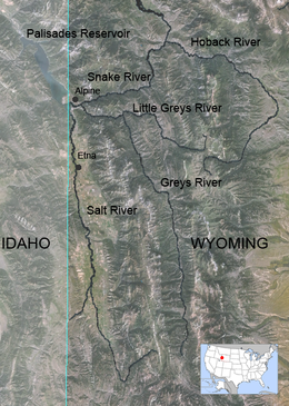
Greys River
Encyclopedia
Snake River
The Snake is a major river of the greater Pacific Northwest in the United States. At long, it is the largest tributary of the Columbia River, the largest North American river that empties into the Pacific Ocean...
, flowing through western Wyoming
Wyoming
Wyoming is a state in the mountain region of the Western United States. The western two thirds of the state is covered mostly with the mountain ranges and rangelands in the foothills of the Eastern Rocky Mountains, while the eastern third of the state is high elevation prairie known as the High...
in the United States
United States
The United States of America is a federal constitutional republic comprising fifty states and a federal district...
. The river is about 62 miles (99.8 km) long, starting high up in the Wyoming Range
Wyoming Range
The Wyoming Range is a mountain range located in west-central Wyoming. It is a range of the Rocky Mountains that runs north-south near the western edge of the state. Its highest peak is Wyoming Peak, which stands at above sea-level. The range is sometimes referred to as The Wyomings.The vast...
, 45 miles (72.4 km) south of the town of Alpine
Alpine, Wyoming
Alpine is a town in Lincoln County, Wyoming, United States. The population was 550 at the 2000 census.-Geography:Alpine is located at the southern end of the Snake River Canyon where the Snake River enters Palisades Reservoir. The town is also known as Alpine Junction since it marks the point...
in Lincoln County. The river eventually flows into the Snake River in the Snake River Canyon
Snake River Canyon (Wyoming)
The Snake River Canyon is formed by the Snake River on the western border of Wyoming south of Jackson Hole. At the southern end of this canyon is the town of Alpine, Wyoming where the Snake River meets the Greys River and the Salt River at Palisades Reservoir on the Wyoming-Idaho border...
, joining it just east of Alpine. The Greys River is generally a rushing mountain stream that separates the high Wyoming Range (east) from the Salt River Range
Salt River Range
The Salt River Range is a mountain range in western Wyoming. The 56 mile long range forms the eastern boundary of Star Valley as well as the western boundary of the Greys River valley.The highest point is Mount Fitzpatrick at ....
(west). It joins the Snake River just above the intersection of U.S. highways 89
U.S. Route 89
U.S. Route 89 is a north–south United States Highway with two sections, and one former section. The southern section runs for 848 miles from Flagstaff, Arizona, to the southern entrance of Yellowstone National Park...
and 26
U.S. Route 26
U.S. Route 26 is an east–west United States highway. It started in Ogallala, Nebraska, and gradually grew to reach the West Coast in Oregon. When the U.S. highway system was first defined, it was limited to Nebraska and Wyoming; by the 1950s, it continued into Idaho and Oregon. The...
. Just a short distance downriver from the confluence of the two rivers, the Snake widens quickly and passes through Alpine and enters the Palisades Reservoir. The largest tributary of the Greys River is the Little Greys River.
In 1997, Greys River hosted the second round of the World Fly-fishing Championship.
See also
- Hoback RiverHoback RiverThe Hoback River, also called the Fall River, is an approximately -long tributary of the Snake River in the U.S. state of Wyoming. It rises in the southern Rocky Mountains of Wyoming and flows northeast through the Teton National Forest, before turning northwest to join the Snake just downstream of...
- Salt RiverSalt River (Wyoming)The Salt River is an river draining a valley in Lincoln County in western Wyoming. It is named for several exposed beds of salt and briny salt springs of up 60% pure salt in Idaho that drains into the Salt River via Stump Creek. The Salt River valley was a popular destination for Indians and later...
- List of rivers in Wyoming