

Gretton, Northamptonshire
Encyclopedia
Gretton is a village in the English
midlands county of Northamptonshire
. It is in Rockingham Forest
and overlooks the valley of the River Welland
and the neighbouring county of Rutland
. At the time of the 2001 census
, the parish had a population of 1,240 people.
It is near the town of Corby
and the Rockingham Motor Speedway
. Gretton takes its name from the phrase "Great Town".
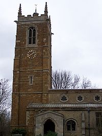
The village is noted for having the tallest church tower in Northamptonshire, and the second-oldest running pub in Northamptonshire, the Hatton Arms. The Hatton Arms was recently renovated.
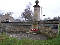
Gretton is one of the few villages to retain its stocks and whipping post, which can be found on the village green. The last recorded use was in 1858 when a villager was put in the stocks for six hours after failing to pay a fine for drunkenness.
Iron currency bars from the Iron Age
have been found, and the Romans
also worked the ironstone deposits. There were ironworks here in Edward the Confessor
's reign in the 11th century, when Gretton was a royal manor, and the industry came to the fore again from 1881 to 1980, providing ore for Corby's steel works.
 Most of the earlier houses - a fair number dating from the 17th century - are built of local limestone, sometimes banded with darker ironstone and roofed with thatch or Collyweston stone slate
.
The buildings in Gretton provide a wide variety, ranging from the centuries-old 'Corner Cottage' in Arnhill Road, to a relatively modern housing estate on the south-east side of the village.
The Old School House, built in 1853, was the first purpose-built school in the village. The infants' classroom at the east end housed 70 children at times. The school operated until 1908 when the present school in Kirby Road was opened. Subsequently it was the village community centre before being converted into a private house in the 1970s.
Barn House, in High Street, is one of the few houses in the village which retains its thatch. In the 1940s there were about 40 thatched houses, now there are merely a handful.
Stoneleigh House, in High Street, was formerly the premises of parchment makers. Springs were fed under the house into ponds which were used for soaking and cleaning the skins. Remnants of the drying sheds and other buildings still exist at the rear.
Opposite the village green is a stone-mullioned building, Tythe Farm, which has been considerably changed and extended, although for much of the last century it was in a serious state of disrepair. In 1919 the district surveyor found it to be unfit for human habitation. To the rear of the farm is the Tythe Barn (rebuilt after being destroyed by a fire in 1985) which used to store the 10% of village produce that went to the church.
Caistor's Cottage, in Caistor Road, once a tiny cottage belonging to a shepherd called Castor.
The Post Office and Stores, in High Street, is part of a Victorian terrace called Pages Row. Formerly owned by a brewery, pigsties at the rear were rented out for sixpence a year. The Gretton Pig Club was in existence from 1876 until 1977.
Overlooking the village green is the 'old' Gretton Stores (now Threeways), whose last storekeeper was Mr. Pegg.It ceased being the stores following a fire in the early sixties which destroyed the upper floor and thatch. The original wooden store sign was rescued by the current owner and is being renovated.
In addition there is the 'newer' former Gretton Stores, now a tea shop and formerly the White Hart pub, which closed in 1931.
Stonycroft, in Station Road, is an 18th-century cottage, with some narrow stone-mullioned windows, and an interesting stonework panel over the door.
Gretton House, in High Street, is Georgian, but has a large neo-Jacobean addition of the 1880s. It was a family home until the Second World War, when it was requisitioned by the War Office as a military hospital. Following the war it became a convalescent home for employees of the Corby steel works. Since 1992 it has been a home for people with Prader-Willi Syndrome
.
Manor Farmhouse, in High Street, is a good example of banded ironstone and limestone, and has a datestone of 1675. Originally called Warren Farm, it overlooked Warren Field, which suggests that this was where the medieval manor obtained its rabbits.
The Old Vicarage, in Station Road, is 17th century with later additions, and was the vicarage until about 1830.
Gretton Primary School, in Kirby Road, has an impressive stone bell tower and was built in 1908, together with the schoolmaster's house. It is still a thriving village school with four classes and over 100 children.
It is a very pretty village.
England
England is a country that is part of the United Kingdom. It shares land borders with Scotland to the north and Wales to the west; the Irish Sea is to the north west, the Celtic Sea to the south west, with the North Sea to the east and the English Channel to the south separating it from continental...
midlands county of Northamptonshire
Northamptonshire
Northamptonshire is a landlocked county in the English East Midlands, with a population of 629,676 as at the 2001 census. It has boundaries with the ceremonial counties of Warwickshire to the west, Leicestershire and Rutland to the north, Cambridgeshire to the east, Bedfordshire to the south-east,...
. It is in Rockingham Forest
Rockingham Forest
Rockingham Forest is a former Mediæval royal hunting forest in the East Midlands region of England; most of which was in the county of Northamptonshire but also extended slightly into the neighbouring counties of Leicestershire and Lincolnshire .The forest originally stretched from Stamford down...
and overlooks the valley of the River Welland
River Welland
The River Welland is a river in the east of England, some long. It rises in the Hothorpe Hills, at Sibbertoft in Northamptonshire, then flows generally northeast to Market Harborough, Stamford and Spalding, to reach The Wash near Fosdyke. For much of its length it forms the county boundary between...
and the neighbouring county of Rutland
Rutland
Rutland is a landlocked county in central England, bounded on the west and north by Leicestershire, northeast by Lincolnshire and southeast by Peterborough and Northamptonshire....
. At the time of the 2001 census
United Kingdom Census 2001
A nationwide census, known as Census 2001, was conducted in the United Kingdom on Sunday, 29 April 2001. This was the 20th UK Census and recorded a resident population of 58,789,194....
, the parish had a population of 1,240 people.
It is near the town of Corby
Corby
Corby Town is a town and borough located in the county of Northamptonshire. Corby Town is 23 miles north-east of the county town, Northampton. The borough had a population of 53,174 at the 2001 Census; the town on its own accounted for 49,222 of this figure...
and the Rockingham Motor Speedway
Rockingham Motor Speedway
Rockingham is the UK's most modern motorsport venue and Europe's fastest racing circuit, hosting corporate driving days, driver training, conferencing & exhibitions, vehicle manufacturing events, track days, testing, driving experiences and motorsport...
. Gretton takes its name from the phrase "Great Town".
The village is noted for having the tallest church tower in Northamptonshire, and the second-oldest running pub in Northamptonshire, the Hatton Arms. The Hatton Arms was recently renovated.
Gretton is one of the few villages to retain its stocks and whipping post, which can be found on the village green. The last recorded use was in 1858 when a villager was put in the stocks for six hours after failing to pay a fine for drunkenness.
Iron currency bars from the Iron Age
Iron Age
The Iron Age is the archaeological period generally occurring after the Bronze Age, marked by the prevalent use of iron. The early period of the age is characterized by the widespread use of iron or steel. The adoption of such material coincided with other changes in society, including differing...
have been found, and the Romans
Roman Empire
The Roman Empire was the post-Republican period of the ancient Roman civilization, characterised by an autocratic form of government and large territorial holdings in Europe and around the Mediterranean....
also worked the ironstone deposits. There were ironworks here in Edward the Confessor
Edward the Confessor
Edward the Confessor also known as St. Edward the Confessor , son of Æthelred the Unready and Emma of Normandy, was one of the last Anglo-Saxon kings of England and is usually regarded as the last king of the House of Wessex, ruling from 1042 to 1066....
's reign in the 11th century, when Gretton was a royal manor, and the industry came to the fore again from 1881 to 1980, providing ore for Corby's steel works.
Landmarks
Collyweston stone slate
Collyweston stone slate is a traditional roofing material found in England.It is not a proper slate but a limestone found in narrow beds. The slates are quarried near the village of Collyweston in Northamptonshire, near Stamford and close to the borders of Lincolnshire and Rutland. It is...
.
The buildings in Gretton provide a wide variety, ranging from the centuries-old 'Corner Cottage' in Arnhill Road, to a relatively modern housing estate on the south-east side of the village.
The Old School House, built in 1853, was the first purpose-built school in the village. The infants' classroom at the east end housed 70 children at times. The school operated until 1908 when the present school in Kirby Road was opened. Subsequently it was the village community centre before being converted into a private house in the 1970s.
Barn House, in High Street, is one of the few houses in the village which retains its thatch. In the 1940s there were about 40 thatched houses, now there are merely a handful.
Stoneleigh House, in High Street, was formerly the premises of parchment makers. Springs were fed under the house into ponds which were used for soaking and cleaning the skins. Remnants of the drying sheds and other buildings still exist at the rear.
Opposite the village green is a stone-mullioned building, Tythe Farm, which has been considerably changed and extended, although for much of the last century it was in a serious state of disrepair. In 1919 the district surveyor found it to be unfit for human habitation. To the rear of the farm is the Tythe Barn (rebuilt after being destroyed by a fire in 1985) which used to store the 10% of village produce that went to the church.
Caistor's Cottage, in Caistor Road, once a tiny cottage belonging to a shepherd called Castor.
The Post Office and Stores, in High Street, is part of a Victorian terrace called Pages Row. Formerly owned by a brewery, pigsties at the rear were rented out for sixpence a year. The Gretton Pig Club was in existence from 1876 until 1977.
Overlooking the village green is the 'old' Gretton Stores (now Threeways), whose last storekeeper was Mr. Pegg.It ceased being the stores following a fire in the early sixties which destroyed the upper floor and thatch. The original wooden store sign was rescued by the current owner and is being renovated.
In addition there is the 'newer' former Gretton Stores, now a tea shop and formerly the White Hart pub, which closed in 1931.
Stonycroft, in Station Road, is an 18th-century cottage, with some narrow stone-mullioned windows, and an interesting stonework panel over the door.
Gretton House, in High Street, is Georgian, but has a large neo-Jacobean addition of the 1880s. It was a family home until the Second World War, when it was requisitioned by the War Office as a military hospital. Following the war it became a convalescent home for employees of the Corby steel works. Since 1992 it has been a home for people with Prader-Willi Syndrome
Prader-Willi syndrome
Prader–Willi syndrome is a rare genetic disorder in which seven genes on chromosome 15 are deleted or unexpressed on the paternal chromosome...
.
Manor Farmhouse, in High Street, is a good example of banded ironstone and limestone, and has a datestone of 1675. Originally called Warren Farm, it overlooked Warren Field, which suggests that this was where the medieval manor obtained its rabbits.
The Old Vicarage, in Station Road, is 17th century with later additions, and was the vicarage until about 1830.
Gretton Primary School, in Kirby Road, has an impressive stone bell tower and was built in 1908, together with the schoolmaster's house. It is still a thriving village school with four classes and over 100 children.
It is a very pretty village.