

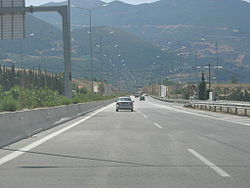
Greek National Road 8A
Encyclopedia

Athens
Athens , is the capital and largest city of Greece. Athens dominates the Attica region and is one of the world's oldest cities, as its recorded history spans around 3,400 years. Classical Athens was a powerful city-state...
up to the northeast of Patras
Patras
Patras , ) is Greece's third largest urban area and the regional capital of West Greece, located in northern Peloponnese, 215 kilometers west of Athens...
. It is a highway from Kifissou avenue up to Corinth
Corinth
Corinth is a city and former municipality in Corinthia, Peloponnese, Greece. Since the 2011 local government reform it is part of the municipality Corinth, of which it is the seat and a municipal unit...
, for about 85 km and the rest is an undivided highway with just one lane per direction. The total length is 215 km, but for the westbound lanes at the 207th km it intersects the Patras Bypass. It is signed as European road E94 from Kifissou Ave in Athens to southwest of Corinth, then it becomes part of E65
European route E65
European route E 65 is a north-south Class-A European route that begins in Malmö, Sweden and ends in Chaniá, Greece. The road is about in length.-Itinerary:* Sweden** E 65: Malmö – Ystad* Baltic sea, ferry Ystad-Świnoujście* Poland...
from Corinth to Rhion interchange, and E55
European route E55
European route E 55 is a E-route. It passes through the following cities:Helsingborg … Helsingør – Copenhagen – Køge – Vordingborg – Nykøbing Falster – Gedser … Rostock – Berlin – Lübbenau – Dresden – Teplice – Prague – Tábor – Linz – Salzburg – Villach – Tarvisio – Udine – Palmanova – Mestre...
from Rhion to north of Patras. The future high-speed railway will run almost entirely from the Corinth Interchange in the west up to the junction with the Attiki Odos where it is within for the rest of its length. Until the reformation of the European Road network, it was known as the E19 which ran in its entire direction except from the Rio Interchange down to Patras.
Construction
The section AthensAthens
Athens , is the capital and largest city of Greece. Athens dominates the Attica region and is one of the world's oldest cities, as its recorded history spans around 3,400 years. Classical Athens was a powerful city-state...
- Corinth
Corinth
Corinth is a city and former municipality in Corinthia, Peloponnese, Greece. Since the 2011 local government reform it is part of the municipality Corinth, of which it is the seat and a municipal unit...
was first opened in November 1962 (except the section Megara
Megara
Megara is an ancient city in Attica, Greece. It lies in the northern section of the Isthmus of Corinth opposite the island of Salamis, which belonged to Megara in archaic times, before being taken by Athens. Megara was one of the four districts of Attica, embodied in the four mythic sons of King...
- Kineta
Kineta
Kineta is a suburban town located 55 km W of Athens, 14 km W of Megara and 25 km E of Corinth. Kineta is the westernmost town in Attica and is part of the municipality of Megara...
(Kakia Skala pass) opened in late 1964 with motorway characteristics). The section Corinth
Corinth
Corinth is a city and former municipality in Corinthia, Peloponnese, Greece. Since the 2011 local government reform it is part of the municipality Corinth, of which it is the seat and a municipal unit...
- Patras
Patras
Patras , ) is Greece's third largest urban area and the regional capital of West Greece, located in northern Peloponnese, 215 kilometers west of Athens...
was first opened in December 1969 as a 14 m width undivided road (except the Aegion bypass, opened in 1973 with motorway characteristics). The E94 part (Athens-Corinth) was upgraded to motorway standards from 1993 to 1997 (the section from Megara to Elefsina and Kineta to the Corinth Canal in 1994, the 2 km section west of Megara in 1995 and the section from the Corinth Canal to near Ancient Corinth in 1997). In Kakia Skala pass, a network of 5 tunnels and several bridges was constructed between 1999 and 2006, converting what was a particularly hazardous and narrow road section to a modern motorway with 3 lanes per direction. A large number of reconstruction and renovation projects were carried out at various parts of the 8A in the 1990s. Additionally, a major overhaul of the 8A is currently under construction as of 2008. Elefsina to Corinth
Corinth
Corinth is a city and former municipality in Corinthia, Peloponnese, Greece. Since the 2011 local government reform it is part of the municipality Corinth, of which it is the seat and a municipal unit...
will be upgraded, while a completely new motorway with tunnels will be built for Corinth
Corinth
Corinth is a city and former municipality in Corinthia, Peloponnese, Greece. Since the 2011 local government reform it is part of the municipality Corinth, of which it is the seat and a municipal unit...
to Patras
Patras
Patras , ) is Greece's third largest urban area and the regional capital of West Greece, located in northern Peloponnese, 215 kilometers west of Athens...
part of Olympia Odos
Olympia Odos
Olympia Odos is a planned major motorway, currently under construction. The motorway will run from Athens all the way down to Tsakona, spanning a total of . Part of the motorway will run parallel to and replace Greek National Road 8A, while parts of it will be upgraded to modern motorway standards...
. The whole project is expected to be completed by 2014, while the Athens
Athens
Athens , is the capital and largest city of Greece. Athens dominates the Attica region and is one of the world's oldest cities, as its recorded history spans around 3,400 years. Classical Athens was a powerful city-state...
to Patras
Patras
Patras , ) is Greece's third largest urban area and the regional capital of West Greece, located in northern Peloponnese, 215 kilometers west of Athens...
part will be completed by 2011.
Route Overview
Here are the complete listings of marking of the 8A, Patras-Corinth, Corinth-Athens Road, also known as Athens-Patras New National Road. Posts are marked going west. The markings here are not by exit numbers:| Kilometre | Features, Interchanges, Junctions |
|---|---|
| 4 | easternmost point of E94 |
| 5 | Thevon Avenue Interchange |
| 27 | Thebes Thebes, Greece Thebes is a city in Greece, situated to the north of the Cithaeron range, which divides Boeotia from Attica, and on the southern edge of the Boeotian plain. It played an important role in Greek myth, as the site of the stories of Cadmus, Oedipus, Dionysus and others... -Eleuthriae Interchange, now cloverleaf Cloverleaf interchange A cloverleaf interchange is a two-level interchange in which left turns, reverse direction in left-driving regions, are handled by ramp roads... |
| 28 | Athens Tollway Attiki Odos Attiki Odos is a privately owned toll motorway in Greece. The Proastiakos high-speed suburban rail is set almost entirely in the median of the motorway, along its main section. The motorway's numbers are 6 for the main section, 64 for the Hymettus Beltway and 65 for the Aigaleo Beltway... (spur) junction, opened in 2004 |
| 30 | Eleusis toll booth |
| 35 | Neos Peramos Interchange |
| 42 | Megara/Old National Road (GR8) Interchange (westbound cloverleaf) |
| 43 | Megara Rest Area, opened 1999 |
| 44 | Megara-Pachi Interchange (cloverleaf) |
| 46 | easternmost point of Kakia Skala |
| 52 | Westernmost point of Kakia Skala |
| 52 | Old Kineta Interchange (closed 2001) |
| 54 | New Kineta Interchange (cloverleaf), opened 1995 |
| 57 | Attica-Corinthia prefectural (departmental/provincial) boundary |
| 62 | Aghioi Theodoroi Toll Interchange |
| 68 | north of the refinery |
| 72 | Isthmia Toll booth |
| 73 | view of Kalamaki |
| 74 | Corinth-Loutraki (Old GR-9) interchange (westbound), old toll booth |
| 75 | Epidaurus (GR-70) Interchange |
| 77 | underpass |
| 78 | West Corinth-Examili Examili Examili is a Greek village in the Thessaloniki area.-History of Examili:The original Examili settlement was located at the beginning of the Gallipoli Peninsula.... Interchange |
| 80 | Tripoli (GR-7 Greek National Road 7 The Moreas Motorway is a motorway in Peloponnese, Greece. Locally it is known as the Moréas , which was the medieval name of the Peloponnese. The A7 begins just west of the Isthmus of Corinth, branching off from Greek National Road 8A... E65 European route E65 European route E 65 is a north-south Class-A European route that begins in Malmö, Sweden and ends in Chaniá, Greece. The road is about in length.-Itinerary:* Sweden** E 65: Malmö – Ystad* Baltic sea, ferry Ystad-Świnoujście* Poland... ) Junction, end of E94 |
| 82 | Argos, Nauplion-Lechaeum (GR-7) Interchange |
| 90 | Corinth rest area (eastbound) |
| 91 | Corinth Toll booth or station |
| 102 | South Kiato Rest Area |
| 106 and 107 | 2 overpasses |
| 108 | Elissus/Elissos River |
| 109 | Kiaton-Stymphalia Interchange |
| 110 | Kiaton Rest Area (westbound) |
| 125 | Xylokastron-Trikkala Interchange |
| 146 | Parking area (both directions) |
| 147 | Akrata-Aigiera Interchange |
| 154 | ELPA Rest Area |
| 158 | Kalavrita-Diacopton(um) Interchange |
| 171 | Texaco Bon Voyage sign (torn down) |
| 172 | Aegion-Pterion-Kalavrita Interchange |
| 173 | GR31 overpass |
| 174 | Aegion Rest Area (Shell gas station/gasbar) |
| 175 | West Aegion |
| 177 | West Aegion/Old GR-9 Interchange, (eastbound, partial) (cloverleaf) |
| 181 | Longos Longos -Places:*In Greece:**Longos, Achaea, a village in Achaea**Longos, Phthiotis, a village in the prefecture of Phthiotis**Longos, Paxoi, a village in the island of Paxoi**Longos, Phocis, a village in the prefecture of Phocis... -Selianitika Selianitika Selianitika , is a Greek coastal village located in northern Peloponnese 187 km west of Athens and nearly 30 km east of Patras. Selianitika and its adjacent village Longos share a beautiful beach which is approximately 1.5 km long. Both villages are among the most popular... -Old GR-8 Interchange |
| 182 | view of Longos |
| 183 | view of Selianitika Selianitika Selianitika , is a Greek coastal village located in northern Peloponnese 187 km west of Athens and nearly 30 km east of Patras. Selianitika and its adjacent village Longos share a beautiful beach which is approximately 1.5 km long. Both villages are among the most popular... |
| 184 | Low railway bridge |
| 187 | Achaea and the Peloponnese Peloponnese The Peloponnese, Peloponnesos or Peloponnesus , is a large peninsula , located in a region of southern Greece, forming the part of the country south of the Gulf of Corinth... 's Northernmost point |
| 205 | Rhion Toll booth or station |
| 206 | Rhion Junction, access to Rio-Antirio bridge Rio-Antirio bridge The Rion-Antirion bridge , officially the Charilaos Trikoupis bridge after the statesman who first envisaged it, is the world's longest multi-span cable-stayed bridge... , Rio and the old road |
| 207 | Patras Interchange, also access to Panachaiko, access to Patras Bypass, opened 2003 |
| 209 to 211 (2 to 4) | Patras Tunnel |
| 209 | University of Patras-Proasteia Junction |
| 212 | Pyrgos-Port of Patras Junction (opened 1996) |
| 213 | Aretha Street Jct. (Skiessa-Hagyia) (former fourth route) |
| 214 | Amerikis Street Jct. (fmr. third route) |
| 215 | Panepistemeiou Street |
| 216 | Downtown Patras |
There are 4 toll stations in the 8A at this time: Eleusis Toll booth, Isthmia toll booth, Corinth toll Booth, and Rhion toll booth at the 205th km. Before the completion of the Rhion-Antirrion Bridge, this part of the highway was the only one connecting the Peloponnese to the rest of Greece. The motorway part has 3 lanes per direction. Rest areas are in Megara
Megara
Megara is an ancient city in Attica, Greece. It lies in the northern section of the Isthmus of Corinth opposite the island of Salamis, which belonged to Megara in archaic times, before being taken by Athens. Megara was one of the four districts of Attica, embodied in the four mythic sons of King...
, Corinth
Corinth
Corinth is a city and former municipality in Corinthia, Peloponnese, Greece. Since the 2011 local government reform it is part of the municipality Corinth, of which it is the seat and a municipal unit...
, between Corinth and Kiato
Kiato
Kiato is a coastal town in Greece that is agricultural-based. The town is located in the northern part of the prefecture of Corinthia in the Peloponnese, Greece. Kiato is located in a sandy area which features lemon trees, orange trees, and other fruit-bearing trees. It has a lot of tourist...
, the old ELPA about 10 km west of Aigeira
Aigeira
Aigeira or Aegira is a former municipality in Achaea, West Greece, Greece. Since the 2011 local government reform it is part of the municipality Aigialeia, of which it is a municipal unit. It is located about 500 m SW of the Gulf of Corinth in the northeastern part of Achaea. It is located on...
and Aigio
Aigio
Aigio is a town and a former municipality in Achaea, West Greece, Greece. Since the 2011 local government reform it is part of the municipality Aigialeia, of which it is the seat and a municipal unit. Its population is around 30,000. Aigio is surrounded by trees in the north and cliffs in the...
.
The semi-highway part from Corinth to Patras is considered to be one of the most dangerous roads in Greece at this time. The features of the road tend to cause many accidents.
Patras Bypass
The bypass of Patras is a motorway that runs from the Mintilogli exit (GR-9), 8.8 km S of Patras up to the Patras exit, nearly 7 km N of the city. Planning of the bypass began in the 1980s, but construction didn't begin until the 1990s, in the region between RoitikaRoitika
Roitika is a village that is located in the municipal unit of Paralia, Achaea, Greece. It is south of the village Paralia. The population is around 2,000 and has a train station and a beach which is 200 m away from the highway. The neighboring communities are Paralia to the north, Mintilogli to...
and Mintilogli
Mintilogli
Mintilogli is a community in the municipal unit of Paralia in Greece, 9 km south of and a suburb of Patras. Its nearest communities are Leyka and Ovrya in the north, Paralia and Roitika to the west and south and Thea and Kallithea in the east...
. Construction reached Dimokratias Street (GR-33) in 1992, the Glafkos
Glafkos
The Glafkos is a river in Greece. It flows into the Gulf of Patras in Patras. The first hydroelectric power plant was built on this river. Currently, it is open to the public as a museum...
river in about the mid-1990s, and the tunnels were constructed in the late-1990s, until 2001. In October 2002, the bypass was opened to traffic. As a result, traffic in downtown Patras has significantly decreased. It was closed for a few days a month after its opening as a result of a mudslide, but was reopened after repairs. The bypass has five interchanges (four full and one partial with a northbound exit at the beginning). It is part of Olympia Odos
Olympia Odos
Olympia Odos is a planned major motorway, currently under construction. The motorway will run from Athens all the way down to Tsakona, spanning a total of . Part of the motorway will run parallel to and replace Greek National Road 8A, while parts of it will be upgraded to modern motorway standards...
(or Motorway A9) for southbound lanes of the bypass, (N) indicates northbound lanes and (S) indicates southbound lanes on the bottom part of the chart.
| Order (south) | Junction |
|---|---|
| Patras Bypass | |
| 1 | 4 tunnels |
| EXIT 2 (S)/4 (N): | Egklykada Egklykada Eglykada or Eglikada also with the first a accented is a neighbourhood in the eastern part of the city of Patras, 7 km by road from the city center. Eglykada is accessed with the Patras-Ekilistra Road which is 2 km long in the neighbourhood... Interchange |
| EXIT 3 | Glafkos Glafkos The Glafkos is a river in Greece. It flows into the Gulf of Patras in Patras. The first hydroelectric power plant was built on this river. Currently, it is open to the public as a museum... Interchange |
| EXIT 4 (S)/2 (N): | Ovrya Interchange, access to GR-33 Greek National Road 33 Greek National Road 33 is a highway that runs from Patras, originally at Dimitris Gounaris Street, now begins at the beltway, and had a branch ending at Olympia, and ends near Vytina, and Levídi, and some think it still ends at Ellinikon near Andritsaina and Megalopolis... |
| EXIT 1 (N): | Mintilogli Mintilogli Mintilogli is a community in the municipal unit of Paralia in Greece, 9 km south of and a suburb of Patras. Its nearest communities are Leyka and Ovrya in the north, Paralia and Roitika to the west and south and Thea and Kallithea in the east... Interchange, access to Patras (N), access to GR-9 Greek National Road 9 Greek National Road 9 is the second-longest national highway of Greece. It runs through the western Peloponnese, from Patras to Pylos. Its length is around .This highway travels near:*Bypasses:*Patras and Area, since 2002*Vrachneika*Alissos*Kato Achaia... (S) |