
Greater Nepal
Encyclopedia
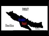
Greater Nepal is a concept referring to the state of Nepal
extending beyond present boundaries to include territories ceded to the British East India Company
under the Sugauli Treaty
that ended the Anglo-Nepalese War in 1814–16. The idea of a modern Nepali state covering the same territories motivates some Nepali nationalist groups.
) and Chaubise(24 in Nepali
) Kingdom.
Because of the loose union of eastern system, Europeans started colonizing those principalities, taking advantage of the weak political situation. Considering the importance of eastern philosophy, culture and Dharma, King Prithivi Narayan Shah tried to unify Nepal. In those days, Nepal was divided into small kingdoms and kingships.
unified the major principalities into one country, especially important for business with Tibet
after the victory over Nuwakot
on October 2 1744, Sindhupal chowk, Kabhrepal chowk, and some kingdoms located to the eastern part of it in 1748 AD. He unified Mahadevpokhari, Pharping, Chitlang, Dharmasthali, Naldrum, Siranchowk and Shivapuri during 1745-46. Immediately after the unification of Makawanpur and Simrongad, he unified Bara
, Parsa
, Rautahat
, and Sindhuli Gadhi in 1762. In 1763 he unified Dhulikhel and Banepa. On 17 March 1766 he captured Kirtipur. In 1768 he unified Kantipur
. Then, relationship of Gorkha kingdom was established with Government of East India Company
. The capital from Gorkha
to Kathmandu was shifted in 1868 AD. After it Prithvi Narayan Shah died at the age of fifty three in 1775 AD, while he was planning to annex Chaudandi
and Vijayapur. Prithvi Narayan Shah was avisionary person. During the reign of Pratap Shah, the son of Prithvi Narayan Shah, three states like Dang
, Kapilvastu
and Chitwan were merged into Nepal. Similarly, Lamjung, Tanahu, Palpa
, Parbat, Upper Nuwakot
, Garahu, Stahu, Bhirkot, and Kaski were conquered in1785. Then, Sarlahi, Mahotttari, Dhanusa, Siraha, Saptari, Sunsari, Morang, Jhapa, Sindhuli, and Udayapur were annexed. In 1769 AD, Jajarkot agreed to absorb its kingdom into Gorkha. Pratap Shah died at the age of twenty five in 1777 AD. after the absorption of the Chitwan Valley of Tanahun. Five Valley of Tanahun. Five years after his demise, Koshi, Lamjung, and Tanahun, including Chaubise kingdoms were galvanized into Nepal in 1789 AD after the absorption of all the Baise Kingdoms (twenty-two principalities), located in the western part of the Kali Gandaki.
Then, Salyan, Palpa and Mustang were annexed.
in 1790 AD.
Pradhumna Shah became the ruler of the nation on condition of paying Rs. 5000 yearly tribute. The southern border of Nepal extended up to Allahabad
after the absorption of Palpa Kingdom, including the Terai sector of Butwal taken by the king of Palpa
from the king of Awadh
on lease in 1801. In 1806 AD, the army of Gorkha absorbed all the small kingdoms like Sirmudh, Hindur and Besahar lying across the Gadhwal and the Satalaj River. In this way, Nepal had intention of acquiring the nearest port of Karanchi and the hilly regions such as Nainital, Almoda, Garhwal
and Deharadun across the Satlaj River.
as far-eastward as the Teesta
and had conquered and annexed the Terai.
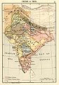 Under the Sugauli Treaty, the Nepalese kingdom had ceded the territories conquered by the British East India Company
that spanned from the Teesta River
in the east, which are constituted in the modern India
n states of Punjab
, Himachal Pradesh
, Sikkim
and Bihar
, West Bengal
and Uttarakhand
and including places such as Almora
, Pathankot
, Kumaon
, Dehradun
, Garhwal
, Sirmur
and Shimla
and Kangra, located to the west of the Sutlej
River in the modern Indian state of Himachal Pradesh
. Nepal also ceded control over kingdom of Sikkim
, whose local ruler, the Chogyal
, had supported the British in the war, as well as the north of the Rajshahi
division of Bangladesh
. The re-acquisition of these territories is a goal held by several Nepali political groups, especially the parts of then Nepal integrated into India only because of the consequence of the Sugauli treaty concluded between British India and the Nepalese government.
As the ceded territories were not restored to Nepal by the British when freedom was granted to the people of British India, these have become a part of the Republic of India even though it was mentioned that the treaties on behalf of the East India Company
or British India would not be valid anymore. Some Nepali politicians and activists accuse India of usurping Nepali territory and using the present border and territorial situation to dominate Nepal, which in the opinion of Nepali nationalists can be overcome by a "Complete (Greater) Nepal." Most law graduates claim that the Sugauli Treaty became null and void on August 15, 1947 when India obtained her independence from British Raj and by the 1950 Indo-Nepal Friendship Treaty. Several Nepalese publications and activities claim the lost territories must be recovered since the Sugauli Treaty has in effect been void by article 8 of the 1950 Indo-Nepal Friendship Treaty and Anglo-Nepal Treaty. The land is being illegally occupied by the Indian government and there are adequate proofs to show that these lands are legally a part of Nepal.
Nepal
Nepal , officially the Federal Democratic Republic of Nepal, is a landlocked sovereign state located in South Asia. It is located in the Himalayas and bordered to the north by the People's Republic of China, and to the south, east, and west by the Republic of India...
extending beyond present boundaries to include territories ceded to the British East India Company
British East India Company
The East India Company was an early English joint-stock company that was formed initially for pursuing trade with the East Indies, but that ended up trading mainly with the Indian subcontinent and China...
under the Sugauli Treaty
Sugauli Treaty
The Sugauli Treaty was signed on December 2, 1815 and ratified by March 4, 1816, between the British East India Company and Nepal, which was a kingdom during that era. This ended the second British invasion of the Himalayan kingdom during the Anglo-Nepalese War...
that ended the Anglo-Nepalese War in 1814–16. The idea of a modern Nepali state covering the same territories motivates some Nepali nationalist groups.
Political situation of the Eastern Society
The eastern administration system was decentralized with Rajauta, Raja, Maharaja, and Badamaharaja ruling villages and states respectively as per the norms of Dharma Rajya. State was not concerned to planning and development, which was a common feature of entire south Asian region. There were more than 565 principalities in the present India alone. Nepal too did have over six dozen Rajya and Rajauta, called Bayeese(22 in NepaliNepali language
Nepali or Nepalese is a language in the Indo-Aryan branch of the Indo-European language family.It is the official language and de facto lingua franca of Nepal and is also spoken in Bhutan, parts of India and parts of Myanmar...
) and Chaubise(24 in Nepali
Nepali language
Nepali or Nepalese is a language in the Indo-Aryan branch of the Indo-European language family.It is the official language and de facto lingua franca of Nepal and is also spoken in Bhutan, parts of India and parts of Myanmar...
) Kingdom.
Because of the loose union of eastern system, Europeans started colonizing those principalities, taking advantage of the weak political situation. Considering the importance of eastern philosophy, culture and Dharma, King Prithivi Narayan Shah tried to unify Nepal. In those days, Nepal was divided into small kingdoms and kingships.
Objective of the unification
Prithvi Narayan Shah was a farsighted king and so he decided to galvanize small states into a strong nation with a view to saving Nepal from being one of the colonies of Britain. He did have full support of all right thinking intellectuals and patriots of the time.Unification campaign
Prithvi Narayan ShahPrithvi Narayan Shah
Prithvi Narayan Shah, King of Nepal was the first king of the House of Shahs to rule Nepal. He is credited for starting the campaign for a unified Nepal, which had been divided and weakened under Malla confederacy. He was the ninth generation descendant of Dravya Shah , the founder of the ruling...
unified the major principalities into one country, especially important for business with Tibet
Tibet
Tibet is a plateau region in Asia, north-east of the Himalayas. It is the traditional homeland of the Tibetan people as well as some other ethnic groups such as Monpas, Qiang, and Lhobas, and is now also inhabited by considerable numbers of Han and Hui people...
after the victory over Nuwakot
Nuwakot
Nuwakot is a village in Nuwakot district of central Nepal. It is the most central settlement in the entire country. Located just 75 km from Kathmandu, this historic town was once the capital of the Valley in the days before the unification of Nepal....
on October 2 1744, Sindhupal chowk, Kabhrepal chowk, and some kingdoms located to the eastern part of it in 1748 AD. He unified Mahadevpokhari, Pharping, Chitlang, Dharmasthali, Naldrum, Siranchowk and Shivapuri during 1745-46. Immediately after the unification of Makawanpur and Simrongad, he unified Bara
Bara District
Bara District of 559,135. Pasaha, Dudhaura and Bangari are the main rivers of Bara. Gamahariya is one of the villages of Bara District which is situated near the border area of India....
, Parsa
Parsa District
-Village Development Committees :*Alau*Amarpatti*Auraha*Bagahi*Bagbana*Bageswori*Bahauri Pidari*Bahurbamatha*Basadilwa*Basantpur*Belwa Parsouni*Beriya Birta*Bhawanipur*Bhedihari*Bhisawa*Bijbaniya*Bindabasini*Biranchibarba*Birganj...
, Rautahat
Rautahat District
-Village Development Committees :*Ajagabi*Akolawa*Auraiya*Badharwa*Bagahi*Bahuwa Madanpur*Bairiya*Banjaraha*Bariyarpur*Basantapatti*Basatpur*Basbiti Jingadiya*Bhalohiya*Bhediyahi*Birtipraskota*Bishrampur*Bisunpurwa Manpur*Brahmapuri...
, and Sindhuli Gadhi in 1762. In 1763 he unified Dhulikhel and Banepa. On 17 March 1766 he captured Kirtipur. In 1768 he unified Kantipur
Kantipur
Kantipur TV is a television network of Kantipur Publication of Nepal. This Publication House has a number of other notable publications such as The Katmandu Post, and kantipur daily....
. Then, relationship of Gorkha kingdom was established with Government of East India Company
East India Company
The East India Company was an early English joint-stock company that was formed initially for pursuing trade with the East Indies, but that ended up trading mainly with the Indian subcontinent and China...
. The capital from Gorkha
Gorkha District
Gorkha District of 288,134. It is the location of the Manakamana Temple. Also, the temples of great sage Gorakh Nath and goddess Gorakh Kali temple is located in district, after which the district got its name. Four major rivers run within and along it, they are Chepe, Daraudi, Marsyangdi and...
to Kathmandu was shifted in 1868 AD. After it Prithvi Narayan Shah died at the age of fifty three in 1775 AD, while he was planning to annex Chaudandi
Chaudandi
Chaudandi is a village development committee in Udayapur District in the Sagarmatha Zone of south-eastern Nepal. At the time of the 1991 Nepal census it had a population of 2715 people living in 469 individual households.-External links:*...
and Vijayapur. Prithvi Narayan Shah was avisionary person. During the reign of Pratap Shah, the son of Prithvi Narayan Shah, three states like Dang
Dang district
Dang is a district in the state of Gujarat in India. The administrative headquarters of the district are located in Ahwa. The Dangs have an area of 1764 km² and a population of 186,729 ....
, Kapilvastu
Kapilvastu District
Kapilvastu district of 481,976.-Geography:The district situated at the height of 93 to 1491 meters from sea level. Geographically, the district can be divided into plain low lands of terai and low Chure hills.Kapilvastu is bounded by-...
and Chitwan were merged into Nepal. Similarly, Lamjung, Tanahu, Palpa
Palpa
Palpa may refer to:In Peru:*Palpa, Peru, near the Nazca Lines*Palpa Province, in the Ica RegionIn Nepal:*Palpa District, a district of Nepal in the Lumbini Zone*Palpa language...
, Parbat, Upper Nuwakot
Nuwakot
Nuwakot is a village in Nuwakot district of central Nepal. It is the most central settlement in the entire country. Located just 75 km from Kathmandu, this historic town was once the capital of the Valley in the days before the unification of Nepal....
, Garahu, Stahu, Bhirkot, and Kaski were conquered in1785. Then, Sarlahi, Mahotttari, Dhanusa, Siraha, Saptari, Sunsari, Morang, Jhapa, Sindhuli, and Udayapur were annexed. In 1769 AD, Jajarkot agreed to absorb its kingdom into Gorkha. Pratap Shah died at the age of twenty five in 1777 AD. after the absorption of the Chitwan Valley of Tanahun. Five Valley of Tanahun. Five years after his demise, Koshi, Lamjung, and Tanahun, including Chaubise kingdoms were galvanized into Nepal in 1789 AD after the absorption of all the Baise Kingdoms (twenty-two principalities), located in the western part of the Kali Gandaki.
Then, Salyan, Palpa and Mustang were annexed.
Victory over Kumau & Garhwal
Army of Gorkha got victory over KumaonKumaon Division
For Kumaoni/Kumauni People see Kumauni PeopleKumaon or Kumaun is one of the two regions and administrative divisions of Uttarakhand, a mountainous state of northern India, the other being Garhwal. It includes the districts of Almora, Bageshwar, Champawat, Nainital, Pithoragarh, and Udham Singh Nagar...
in 1790 AD.
Pradhumna Shah became the ruler of the nation on condition of paying Rs. 5000 yearly tribute. The southern border of Nepal extended up to Allahabad
Allahabad
Allahabad , or Settled by God in Persian, is a major city of India and is one of the main holy cities of Hinduism. It was renamed by the Mughals from the ancient name of Prayaga , and is by some accounts the second-oldest city in India. It is located in the north Indian state of Uttar Pradesh,...
after the absorption of Palpa Kingdom, including the Terai sector of Butwal taken by the king of Palpa
Palpa District
-Village Development Committee :*Archale*Argali*Bahadurpur*Bakamalang*Baldengadhi*Bandi Pokhara*Barangdi old name archale barangdi name came from barandi khola on the bank of this river the famous rani mahal is situated*Bhairabsthan*Bhuwan...
from the king of Awadh
Awadh
Awadh , also known in various British historical texts as Oudh or Oude derived from Ayodhya, is a region in the centre of the modern Indian state of Uttar Pradesh, which was before independence known as the United Provinces of Agra and Oudh...
on lease in 1801. In 1806 AD, the army of Gorkha absorbed all the small kingdoms like Sirmudh, Hindur and Besahar lying across the Gadhwal and the Satalaj River. In this way, Nepal had intention of acquiring the nearest port of Karanchi and the hilly regions such as Nainital, Almoda, Garhwal
Garhwal Kingdom
Garhwal Kingdom was a princely state in north-western Uttarakhand, India, ruled by the Panwar dynasty. It was founded in 888 AD and existed until it was annexed by the Gorkhas in 1803...
and Deharadun across the Satlaj River.
Victory over Sikkim & Darjeeling
Previously Darjeeling formed a part of dominions of the Raja of Sikkim, who had been engaged in an unsuccessful warfare against the Gorkhas. From 1780 the Gorkhas constately made inroads into Sikkim. In the Sino-Nepal treaty, Sikkim lost some of its land to Nepal and by the beginning of 19th century, they had overrun SikkimSikkim
Sikkim is a landlocked Indian state nestled in the Himalayan mountains...
as far-eastward as the Teesta
Teesta River
River Teesta or Tista is said to be the lifeline of the Indian state of Sikkim, flowing for almost the entire length of the state and carving out verdant Himalayan temperate and tropical river valleys. The emerald-coloured river then forms the border between Sikkim and West Bengal before joining...
and had conquered and annexed the Terai.
Historic boundaries
British East India Company
The East India Company was an early English joint-stock company that was formed initially for pursuing trade with the East Indies, but that ended up trading mainly with the Indian subcontinent and China...
that spanned from the Teesta River
Teesta River
River Teesta or Tista is said to be the lifeline of the Indian state of Sikkim, flowing for almost the entire length of the state and carving out verdant Himalayan temperate and tropical river valleys. The emerald-coloured river then forms the border between Sikkim and West Bengal before joining...
in the east, which are constituted in the modern India
India
India , officially the Republic of India , is a country in South Asia. It is the seventh-largest country by geographical area, the second-most populous country with over 1.2 billion people, and the most populous democracy in the world...
n states of Punjab
Punjab (India)
Punjab ) is a state in the northwest of the Republic of India, forming part of the larger Punjab region. The state is bordered by the Indian states of Himachal Pradesh to the east, Haryana to the south and southeast and Rajasthan to the southwest as well as the Pakistani province of Punjab to the...
, Himachal Pradesh
Himachal Pradesh
Himachal Pradesh is a state in Northern India. It is spread over , and is bordered by the Indian states of Jammu and Kashmir on the north, Punjab on the west and south-west, Haryana and Uttar Pradesh on the south, Uttarakhand on the south-east and by the Tibet Autonomous Region on the east...
, Sikkim
Sikkim
Sikkim is a landlocked Indian state nestled in the Himalayan mountains...
and Bihar
Bihar
Bihar is a state in eastern India. It is the 12th largest state in terms of geographical size at and 3rd largest by population. Almost 58% of Biharis are below the age of 25, which is the highest proportion in India....
, West Bengal
West Bengal
West Bengal is a state in the eastern region of India and is the nation's fourth-most populous. It is also the seventh-most populous sub-national entity in the world, with over 91 million inhabitants. A major agricultural producer, West Bengal is the sixth-largest contributor to India's GDP...
and Uttarakhand
Uttarakhand
Uttarakhand , formerly Uttaranchal, is a state in the northern part of India. It is often referred to as the Land of Gods due to the many holy Hindu temples and cities found throughout the state, some of which are among Hinduism's most spiritual and auspicious places of pilgrimage and worship...
and including places such as Almora
Almora
Almora is a municipal board, a cantonment town in the Almora district in the state of Uttarakhand, India. Almora was founded in 1568.It is a town bustling with activity and a rich cultural heritage and history. It is considered the cultural heart of the Kumaon region of...
, Pathankot
Pathankot
Pathankot became 22nd district on 28th July 2011 and a municipal corporation in the Indian state of Punjab. It was a part of the Nurpur princely state ruled by the Rajputs prior to 1849 AD. It is a meeting point of the three northern states of Punjab, Himachal Pradesh and Jammu and Kashmir...
, Kumaon
Kumaon Division
For Kumaoni/Kumauni People see Kumauni PeopleKumaon or Kumaun is one of the two regions and administrative divisions of Uttarakhand, a mountainous state of northern India, the other being Garhwal. It includes the districts of Almora, Bageshwar, Champawat, Nainital, Pithoragarh, and Udham Singh Nagar...
, Dehradun
Dehradun
- Geography :The Dehradun district has various types of physical geography from Himalayan mountains to Plains. Raiwala is the lowest point at 315 meters above sea level, and the highest points are within the Tiuni hills, rising to 3700 m above sea level...
, Garhwal
Garhwal Division
Garhwal is the north-western region and administrative division of the northern Indian state of Uttarakhand which is home to the Garhwali people. Lying in the Himalayas, It is bounded on the north by Tibet, on the east by Kumaon region, on the south by Uttar Pradesh state, and on the north-west by...
, Sirmur
Sirmur
Sirmur was an independent kingdom in India, founded in 1616. It became a part of Greater Nepal, before becoming a princely state in British India, located in the region that is now the Sirmaur district of Himachal Pradesh. The state was also known as Nahan, after its main city, Nahan...
and Shimla
Shimla
Shimla , formerly known as Simla, is the capital city of Himachal Pradesh. In 1864, Shimla was declared the summer capital of the British Raj in India. A popular tourist destination, Shimla is often referred to as the "Queen of Hills," a term coined by the British...
and Kangra, located to the west of the Sutlej
Sutlej
The Sutlej River is the longest of the five rivers that flow through the historic crossroad region of Punjab in northern India and Pakistan. It is located north of the Vindhya Range, south of the Hindu Kush segment of the Himalayas, and east of the Central Sulaiman Range in Pakistan.The Sutlej...
River in the modern Indian state of Himachal Pradesh
Himachal Pradesh
Himachal Pradesh is a state in Northern India. It is spread over , and is bordered by the Indian states of Jammu and Kashmir on the north, Punjab on the west and south-west, Haryana and Uttar Pradesh on the south, Uttarakhand on the south-east and by the Tibet Autonomous Region on the east...
. Nepal also ceded control over kingdom of Sikkim
Sikkim
Sikkim is a landlocked Indian state nestled in the Himalayan mountains...
, whose local ruler, the Chogyal
Chogyal
The Chogyal were the monarchs of the former kingdoms of Sikkim and Ladakh, which were ruled by separate branches of the Namgyal family. The Chogyal, or divine ruler, was the absolute potentate of Sikkim from 1642 to 1975, when its monarchy was abrogated and its people voted to make Sikkim India's...
, had supported the British in the war, as well as the north of the Rajshahi
Rajshahi
The city of Rajshahi is the divisional headquarters of Rajshahi division as well as the administrative district that bears its name and is one of the six metropolitan cities of Bangladesh. Often referred to as Silk City and Education City, Rajshahi is located in the north-west of the country and...
division of Bangladesh
Bangladesh
Bangladesh , officially the People's Republic of Bangladesh is a sovereign state located in South Asia. It is bordered by India on all sides except for a small border with Burma to the far southeast and by the Bay of Bengal to the south...
. The re-acquisition of these territories is a goal held by several Nepali political groups, especially the parts of then Nepal integrated into India only because of the consequence of the Sugauli treaty concluded between British India and the Nepalese government.
Nationalist cause
The idea of "Complete (Greater) Nepal" motivates not only some Nepali nationalists but a majority of Nepalese academicians, who seek to extend the boundaries of present-day Nepal to include the very territories ceded under the Sugauli Treaty.As the ceded territories were not restored to Nepal by the British when freedom was granted to the people of British India, these have become a part of the Republic of India even though it was mentioned that the treaties on behalf of the East India Company
East India Company
The East India Company was an early English joint-stock company that was formed initially for pursuing trade with the East Indies, but that ended up trading mainly with the Indian subcontinent and China...
or British India would not be valid anymore. Some Nepali politicians and activists accuse India of usurping Nepali territory and using the present border and territorial situation to dominate Nepal, which in the opinion of Nepali nationalists can be overcome by a "Complete (Greater) Nepal." Most law graduates claim that the Sugauli Treaty became null and void on August 15, 1947 when India obtained her independence from British Raj and by the 1950 Indo-Nepal Friendship Treaty. Several Nepalese publications and activities claim the lost territories must be recovered since the Sugauli Treaty has in effect been void by article 8 of the 1950 Indo-Nepal Friendship Treaty and Anglo-Nepal Treaty. The land is being illegally occupied by the Indian government and there are adequate proofs to show that these lands are legally a part of Nepal.
See also
- British East India CompanyBritish East India CompanyThe East India Company was an early English joint-stock company that was formed initially for pursuing trade with the East Indies, but that ended up trading mainly with the Indian subcontinent and China...
, British RajBritish RajBritish Raj was the British rule in the Indian subcontinent between 1858 and 1947; The term can also refer to the period of dominion... - History of IndiaHistory of IndiaThe history of India begins with evidence of human activity of Homo sapiens as long as 75,000 years ago, or with earlier hominids including Homo erectus from about 500,000 years ago. The Indus Valley Civilization, which spread and flourished in the northwestern part of the Indian subcontinent from...
- History of NepalHistory of NepalThe history of Nepal is characterized by its isolated position in the Himalayas and its two neighbors, India and China.Due to the arrival of disparate settler groups from outside through the ages, it is now a multi-ethnic, multi-cultural, multilingual country...
- History of SikkimHistory of SikkimThe history of Sikkim begins with ancient Hindu and Tibetan contacts, followed by the establishment of a Tibetan kingdom in the 17th century. Sikkim emerged as a polity in its own right against a backdrop of incursions from Tibet and Bhutan, during which the kingdom enjoyed varying degrees of...
- Politics of NepalPolitics of NepalThe politics of Nepal function within a framework of a republic with a multi-party system.Currently, the position of President is occupied by Ram Baran Yadav. The position of Prime Minister is held by Dr. Baburam Bhattarai...
External links
- Greaternepal.org
- We could regain Greater Nepal
- Newsblaze.com
- Bellinfosys.com (important dates in the history of Garhwal.)
- Wordpress.com
- Bordernepal.com