

Great South Wall
Encyclopedia
The Great South Wall at the Port of Dublin
, extends from Ringsend
nearly four miles out into Dublin Bay
. It was the world's longest sea-wall at the time of its building, remaining one of the longest in Europe. It faces the later-built Bull Wall
, and has one of a trio of port lighthouses at its end.
, and held major sand banks, notably the North Bull and South Bull (both hard sand dry at low water), to either side of the Liffey mouth, along with the Kish Bank
over 1 km out to sea. Between the North and South Bulls, a sand bar existed, rising over time, limiting access to the city quays.
Furthermore, the shape of the Liffey estuary was rather different from the present day, with the river channel not fully enclosed, much of Pearse Street (then Lazey Hill) running along the shore, which then bent sharply south, running in a diagonal to Irishtown
, with Ringsend
being a narrow sand spit projecting north into the bay.
, adjacent to Ringsend.
, the Dublin City Assembly authorised the building of an embankment from Ringsend along the north aspect of the South Bull sand bank. The first piles of what was to become the South Bull Wall were driven that year, and major work commenced in 1717, with what was then known simply as The Piles completed in 1730 to 1731. Construction involved driving of oaken piles into the boulder clay of Dublin Bay, with these anchored by baskets of gravel, and woven wattles.
A stone wall linking The Piles to the quays, The Ballast Office Wall, was completed in 1756, and the first Pigeon House at the shoreward end of the piles was built around 1760 as a residence for a caretaker. Over a period, a bank of sand and other debris, the White Bank, developed adjacent to the wall about 800m seawards of the Pigeon House.
The driven-pile barrier was breached by storm action, after reported rotting and tidal stress, and in 1761
, a stone pier was commenced, working from the Poolbeg Lighthouse (commenced in 1761, operational 1767) back to shore. The construction, of massive granite blocks, brought from quarries at Dalkey
, was completed in 1795
. The final wall dimensions were 32 feet at the base, tapering to 28 feet at the top.
In the meantime, in 1791, the Pigeon House Harbour was planned, while in 1793, a gun battery, named the Half-Moon Battery for its shape, was built about 800m shorewards of the lighthouse. Also around 1793, a hotel, the Pigeon House Hotel was opened.
Following temporary military arrangements after the 1798 Rebellion, the Pigeon House Fort was created, maintained from 1814 to 1897. At its peak, it included gates with trenches crossed by drawbridges at the beginning of the wall, quarters for officers and men, a hospital, armoury, magazine and stores. In 1897, the complex was sold to Dublin Corporation
for development to include the city’s first major electricity generating station and a sewage processing facility, as well as reuse of the hospital. This followed the installation, between 1878 and 1881, of a sewage pipe along the wall, discharging at the White Bank.
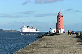 At the seaward end of the wall stands the red-painted Poolbeg Lighthouse
, standing in its current form since 1820, having replaced an earlier light-tower, which in turn replaced a 1782 light-ship. The Ordnance Survey, and later Ordnance Survey Ireland
, used the low water mark of the spring tide on the 8th April 1837 at the lighthouse as the standard height datum for Ireland until 1958.http://www.osi.ie/gps/overview/irishgrid.asp
Dublin Port
Dublin Port is Ireland's biggest sea port. It has both historical and contemporary economic importance. Approximatively two-thirds of the Republic of Ireland's port traffic goes via Dublin Port...
, extends from Ringsend
Ringsend
Ringsend is a southside inner suburb of Dublin, the capital of Ireland. It is located on the south bank of the River Liffey, about two kilometres east of the city centre, and is the southern terminus of the East Link Toll Bridge....
nearly four miles out into Dublin Bay
Dublin Bay
Dublin Bay is a C-shaped inlet of the Irish Sea on the east coast of Ireland. The bay is about 10 kilometres wide along its north-south base, and 7 km in length to its apex at the centre of the city of Dublin; stretching from Howth Head in the north to Dalkey Point in the south...
. It was the world's longest sea-wall at the time of its building, remaining one of the longest in Europe. It faces the later-built Bull Wall
Bull Wall
The Bull Wall, or North Bull Wall, at the Port of Dublin, extending from the estuary of the River Tolka and the district of Clontarf out nearly 3 km into Dublin Bay, is one of the two defining sea walls of the port, and faces the earlier-constructed Great South Wall...
, and has one of a trio of port lighthouses at its end.
Background
Dublin Bay had a long-running problem with silting, notably at the mouth of the River LiffeyRiver Liffey
The Liffey is a river in Ireland, which flows through the centre of Dublin. Its major tributaries include the River Dodder, the River Poddle and the River Camac. The river supplies much of Dublin's water, and a range of recreational opportunities.-Name:The river was previously named An Ruirthech,...
, and held major sand banks, notably the North Bull and South Bull (both hard sand dry at low water), to either side of the Liffey mouth, along with the Kish Bank
Kish Bank
The Kish Bank is a shallow sand bank about seven miles off the coast of Dublin, in Ireland. It is marked by the Kish Lighthouse, a landmark well known to sailors and ferry passengers passing through Dublin Bay and Dún Laoghaire harbour.Many ships were wrecked on these shallows...
over 1 km out to sea. Between the North and South Bulls, a sand bar existed, rising over time, limiting access to the city quays.
Furthermore, the shape of the Liffey estuary was rather different from the present day, with the river channel not fully enclosed, much of Pearse Street (then Lazey Hill) running along the shore, which then bent sharply south, running in a diagonal to Irishtown
Irishtown
Irishtown may refer to:* Irishtown, Dublin, Ireland* Irishtown Stadium* Irishtown, County Antrim, a townland in County Antrim, Northern Ireland* Irishtown, County Mayo, a village in County Mayo, Ireland* Irishtown, Newfoundland and Labrador, Canada...
, with Ringsend
Ringsend
Ringsend is a southside inner suburb of Dublin, the capital of Ireland. It is located on the south bank of the River Liffey, about two kilometres east of the city centre, and is the southern terminus of the East Link Toll Bridge....
being a narrow sand spit projecting north into the bay.
To Ringsend
Reclamation of the lands between the city and Ringsend progressed during the 17th and early 18th century, accelerated by the foundation of the Ballast Office in 1707, and by the granting of an estate there to Sir John Rogerson in 1713. Rogerson paid for a massive quay, all the way to a new mouth for the River DodderRiver Dodder
The River Dodder is one of the three main rivers of the Dublin region in Ireland, the others being the Liffey, of which the Dodder is the largest tributary, and the Tolka.-Course and system:...
, adjacent to Ringsend.
Commencement
Years of primitive dredging were succeeded by an attempt to maintain a clear main channel to Dublin more effectively when, in 17151715 in Ireland
-Births:*Sir William Johnson, 1st Baronet, pioneer and army officer in colonial New York .*Patrick Lynch, emigrant to Rio de la Plata, and successful landowner.-Deaths:...
, the Dublin City Assembly authorised the building of an embankment from Ringsend along the north aspect of the South Bull sand bank. The first piles of what was to become the South Bull Wall were driven that year, and major work commenced in 1717, with what was then known simply as The Piles completed in 1730 to 1731. Construction involved driving of oaken piles into the boulder clay of Dublin Bay, with these anchored by baskets of gravel, and woven wattles.
A stone wall linking The Piles to the quays, The Ballast Office Wall, was completed in 1756, and the first Pigeon House at the shoreward end of the piles was built around 1760 as a residence for a caretaker. Over a period, a bank of sand and other debris, the White Bank, developed adjacent to the wall about 800m seawards of the Pigeon House.
The driven-pile barrier was breached by storm action, after reported rotting and tidal stress, and in 1761
1761 in Ireland
-Births:*20 July - Arthur Gore, 3rd Earl of Arran, politician .*17 September - Samuel Neilson, one of the founder members of the Society of United Irishmen and the founder of its newspaper the Northern Star .-Full date unknown:...
, a stone pier was commenced, working from the Poolbeg Lighthouse (commenced in 1761, operational 1767) back to shore. The construction, of massive granite blocks, brought from quarries at Dalkey
Dalkey
Dalkey is suburb of Dublin and seaside resort in Dun Laoghaire-Rathdown County, Ireland. It was founded as a Viking settlement and became an important port during the Middle Ages. According to John Clyn, it was one of the ports through which the plague entered Ireland in the mid-14th century...
, was completed in 1795
1795 in Ireland
-Events:*5 June - The Royal College of St Patrick established at Maynooth by Act of Grattan's Parliament to provide university-level education for Roman Catholic ecclesiastical and lay students.*21 September...
. The final wall dimensions were 32 feet at the base, tapering to 28 feet at the top.
In the meantime, in 1791, the Pigeon House Harbour was planned, while in 1793, a gun battery, named the Half-Moon Battery for its shape, was built about 800m shorewards of the lighthouse. Also around 1793, a hotel, the Pigeon House Hotel was opened.
Following temporary military arrangements after the 1798 Rebellion, the Pigeon House Fort was created, maintained from 1814 to 1897. At its peak, it included gates with trenches crossed by drawbridges at the beginning of the wall, quarters for officers and men, a hospital, armoury, magazine and stores. In 1897, the complex was sold to Dublin Corporation
Dublin Corporation
Dublin Corporation , known by generations of Dubliners simply as The Corpo, is the former name given to the city government and its administrative organisation in Dublin between 1661 and 1 January 2002...
for development to include the city’s first major electricity generating station and a sewage processing facility, as well as reuse of the hospital. This followed the installation, between 1878 and 1881, of a sewage pipe along the wall, discharging at the White Bank.
Structure and access
Much of the wall is now encompassed by port facilities, or lies within the Poolbeg Generation Station complex. Public access now generally begins with the part of the wall just beyond the power station, which has parking adjacent. The area is only served twice daily by public transport, in early morning and evening, with a bus stop past Poolbeg power station as the terminus of Dublin Bus route no 1.Poolbeg Lighthouse
Poolbeg Lighthouse in Dublin Bay was built in 1768 and initially operated on candlepower but changed to oil in 1786...
, standing in its current form since 1820, having replaced an earlier light-tower, which in turn replaced a 1782 light-ship. The Ordnance Survey, and later Ordnance Survey Ireland
Ordnance Survey Ireland
Ordnance Survey Ireland is the national mapping agency of the Republic of Ireland and, together with the Ordnance Survey of Northern Ireland , succeeded, after 1922, the Irish operations of the United Kingdom Ordnance Survey. It is part of the Public service of the Republic of Ireland...
, used the low water mark of the spring tide on the 8th April 1837 at the lighthouse as the standard height datum for Ireland until 1958.http://www.osi.ie/gps/overview/irishgrid.asp
External sources
- Ball, Francis Elrington: Dublin, Ireland: A History of the County Dublin, Vol. 2 (Parishes of Donnybrook)
- Joyce, Weston St. John: Dublin, Ireland, 1920: "The Neighbourhood of Dublin", Chapter II, "The Poolbeg Lighthouse and the South Wall Extension, etc."