
Kish Bank
Encyclopedia
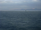
The Kish Bank is a shallow sand bank about seven miles (11 km) off the coast of Dublin, in Ireland
. It is marked by the Kish Lighthouse, a landmark well known to sailors and ferry
passengers passing through Dublin Bay
and Dún Laoghaire
harbour.
Many ships were wrecked on these shallows. The Vesper was lost in January 1876; the Norwegian MV Bolivar ran aground on the Kish Bank during a snow storm on 4 March 1947; both wrecks are frequently dived
. A mailboat operated by the City of Dublin Steam Packet Company between Kingstown (later Dún Laoghaire) and Holyhead, the RMS Leinster
, was torpedoed and sunk by a German submarine on 10 October 1918. She went down four miles (6 km) east of the Kish Lighthouse with over 500 lives lost, the greatest single loss of life in the Irish Sea. Fifty-five wrecks are listed for the Kish Bank area at Irish Wrecks Online.
In 2000, the Department of Marine and Natural Resources awarded licenses to allow detailed studies to be carried out on the Kish and Bray Banks in relation to the construction of a large offshore wind farm. Press reports at the time suggested 100 or more wind turbines might be erected.
since 1811. An attempt to build a lighthouse in 1842 was abandoned because of destruction caused by severe weather. The first Irish electric lightvessel, the Gannet, was installed in 1954.
The Commissioners of Irish Lights
decided in 1960 to erect a reinforced concrete lighthouse with helicopter landing pad on top and this was completed and installed in 1965, with a projected lifetime of 75 years. The sand bank was bored in 1961 and a seismic survey revealed about 300 feet (91.4 m) of sand at the site. Construction began in Dún Laoghaire in 1963. The completed structure was towed from the harbour out to the sandbank on 29 June 1965. The tower was raised on 27 July 1965 to its full height of 100 feet (30.5 m), with twelve floors inside, and with a 32 feet (9.8 m) wide helicopter platform on top.
The lightvessel was removed on 9 November 1965 and the new lighthouse replaced it, operating at between two and three million candlepowers, depending on visibility conditions. The beam is visible for 27 nmi (50 km). The lighthouse was automated on 7 April 1992, and the keepers came ashore.
Republic of Ireland
Ireland , described as the Republic of Ireland , is a sovereign state in Europe occupying approximately five-sixths of the island of the same name. Its capital is Dublin. Ireland, which had a population of 4.58 million in 2011, is a constitutional republic governed as a parliamentary democracy,...
. It is marked by the Kish Lighthouse, a landmark well known to sailors and ferry
Ferry
A ferry is a form of transportation, usually a boat, but sometimes a ship, used to carry primarily passengers, and sometimes vehicles and cargo as well, across a body of water. Most ferries operate on regular, frequent, return services...
passengers passing through Dublin Bay
Dublin Bay
Dublin Bay is a C-shaped inlet of the Irish Sea on the east coast of Ireland. The bay is about 10 kilometres wide along its north-south base, and 7 km in length to its apex at the centre of the city of Dublin; stretching from Howth Head in the north to Dalkey Point in the south...
and Dún Laoghaire
Dún Laoghaire
Dún Laoghaire or Dún Laoire , sometimes anglicised as "Dunleary" , is a suburban seaside town in County Dublin, Ireland, about twelve kilometres south of Dublin city centre. It is the county town of Dun Laoghaire-Rathdown County and a major port of entry from Great Britain...
harbour.
Many ships were wrecked on these shallows. The Vesper was lost in January 1876; the Norwegian MV Bolivar ran aground on the Kish Bank during a snow storm on 4 March 1947; both wrecks are frequently dived
Scuba diving
Scuba diving is a form of underwater diving in which a diver uses a scuba set to breathe underwater....
. A mailboat operated by the City of Dublin Steam Packet Company between Kingstown (later Dún Laoghaire) and Holyhead, the RMS Leinster
RMS Leinster
RMS Leinster was a vessel operated by the City of Dublin Steam Packet Company, served as the Kingstown -Holyhead mailboat until she was torpedoed and sunk by German submarine UB-123 on 10 October 1918, while bound for Holyhead. She went down just outside Dublin Bay at a point four miles east of...
, was torpedoed and sunk by a German submarine on 10 October 1918. She went down four miles (6 km) east of the Kish Lighthouse with over 500 lives lost, the greatest single loss of life in the Irish Sea. Fifty-five wrecks are listed for the Kish Bank area at Irish Wrecks Online.
In 2000, the Department of Marine and Natural Resources awarded licenses to allow detailed studies to be carried out on the Kish and Bray Banks in relation to the construction of a large offshore wind farm. Press reports at the time suggested 100 or more wind turbines might be erected.
The lighthouse
Before the present Kish Lighthouse was installed in 1965, the sand bank had been signalled by a lightshipLightvessel
A lightvessel, or lightship, is a ship which acts as a lighthouse. They are used in waters that are too deep or otherwise unsuitable for lighthouse construction...
since 1811. An attempt to build a lighthouse in 1842 was abandoned because of destruction caused by severe weather. The first Irish electric lightvessel, the Gannet, was installed in 1954.
The Commissioners of Irish Lights
Commissioners of Irish Lights
The Commissioners of Irish Lights is the body that serves as the lighthouse authority for Ireland plus its adjacent seas and islands...
decided in 1960 to erect a reinforced concrete lighthouse with helicopter landing pad on top and this was completed and installed in 1965, with a projected lifetime of 75 years. The sand bank was bored in 1961 and a seismic survey revealed about 300 feet (91.4 m) of sand at the site. Construction began in Dún Laoghaire in 1963. The completed structure was towed from the harbour out to the sandbank on 29 June 1965. The tower was raised on 27 July 1965 to its full height of 100 feet (30.5 m), with twelve floors inside, and with a 32 feet (9.8 m) wide helicopter platform on top.
The lightvessel was removed on 9 November 1965 and the new lighthouse replaced it, operating at between two and three million candlepowers, depending on visibility conditions. The beam is visible for 27 nmi (50 km). The lighthouse was automated on 7 April 1992, and the keepers came ashore.
See also
- List of islands of Ireland
- Coastal landforms of IrelandCoastal landforms of IrelandIreland is an island surrounded by water, with a 7,500 kilometre coastline. This list catalogues about 400 of the coastal landforms of the island including bays, estuaries, harbours, headlands, and many others...
- List of lighthouses in Ireland
- Commissioners of Irish LightsCommissioners of Irish LightsThe Commissioners of Irish Lights is the body that serves as the lighthouse authority for Ireland plus its adjacent seas and islands...