

Great Ridge
Encyclopedia
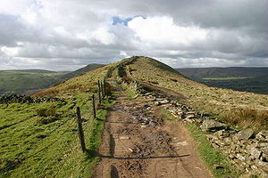
Ridge
A ridge is a geological feature consisting of a chain of mountains or hills that form a continuous elevated crest for some distance. Ridges are usually termed hills or mountains as well, depending on size. There are several main types of ridges:...
separating the vales of Edale
Edale
Edale is a small Derbyshire village and Civil parish in the Peak District, in the Midlands of England. The Parish of Edale,area ,is in the Borough of High Peak....
and Castleton. It covers approximately 3 kilometres from Mam Tor
Mam Tor
Mam Tor is a hill near Castleton in the High Peak of Derbyshire, England. Its name literally translates as Heights of the Mother and it is also known as the Shivering Mountain on account of the instability of its lower shale layers...
at the western end of the ridge to Lose Hill
Lose Hill
Lose Hill lies in the Derbyshire Peak District. It is the south-west corner of the parish of Edale and the end of the Great Ridge that runs from Rushup Edge to the west .Local access activist G. H. B...
at the eastern end, the lowest point being Hollins Cross
Hollins Cross
Hollins Cross lies between Mam Tor and Lose Hill on the Great Ridge that separates Castleton and Edale in Derbyshire, England.Hollins Cross is the lowest point on the ridge and is therefore a popular route taken with casual walkers either wishing to cross from one side to the other, or to start a...
, where the most often used path up to, or over the ridge, runs.
A path runs along the length of the ridge, and is roughly paved to prevent erosion from the large amount of visitors. The only steep section of the path is Back Tor just east of Hollins Cross
Hollins Cross
Hollins Cross lies between Mam Tor and Lose Hill on the Great Ridge that separates Castleton and Edale in Derbyshire, England.Hollins Cross is the lowest point on the ridge and is therefore a popular route taken with casual walkers either wishing to cross from one side to the other, or to start a...
, which may not be suitable for the very infirm.
West of Mam Tor, the high ground continues, slightly changing direction, as Rushup Edge
Rushup Edge
Rushup Edge is a ridge in the Derbyshire Peak District of England. The ridge's highest point is Lord's Seat at , while Mam Tor lies at its eastern end, beyond which the Great Ridge runs.-References:...
.
External links
- The Great Ridge (pdf) - description and map of a walk along the ridge from Country Walking