
Great Calva
Encyclopedia
Fell
“Fell” is a word used to refer to mountains, or certain types of mountainous landscape, in Scandinavia, the Isle of Man, and parts of northern England.- Etymology :...
in the Lake District, England. It is in the Northern Fells
Northern Fells
The Northern Fells are a group of hills in the English Lake District. Including Skiddaw, they occupy a wide area to the north of Keswick. Smooth sweeping slopes predominate with a minimum of tarns or crags...
, lying roughly at the centre of this region of high ground. As a result it is distant from roads and quite remote by Lakeland standards. Great Calva stands at the head of a major geological fault running through the centre of the Lake District, and so from the summit it is possible to see all the way south over Thirlmere
Thirlmere
Thirlmere is a reservoir in the Borough of Allerdale in Cumbria and the English Lake District. It runs roughly south to north, with a dam at the northern end, and is bordered on the eastern side by the A591 road and on the western side by a minor road....
. The subsidiary summit of Little Calva lies to the west.
Topography
SkiddawSkiddaw
Skiddaw is a mountain in the Lake District National Park in England. With a summit at 931 m above sea level it is the fourth highest mountain in England. It lies just north of the town of Keswick, Cumbria, and dominates the skyline in this part of the northern lakes...
and Blencathra
Blencathra
Blencathra, also known as Saddleback, is one of the most northerly mountains in the English Lake District. It has six separate fell tops, of which the highest is the Hallsfell Top.-Name:...
are the best known of the Northern Fells, fronting the range as they loom above Keswick
Keswick, Cumbria
Keswick is a market town and civil parish within the Borough of Allerdale in Cumbria, England. It had a population of 4,984, according to the 2001 census, and is situated just north of Derwent Water, and a short distance from Bassenthwaite Lake, both in the Lake District National Park...
and the road to Penrith
Penrith, Cumbria
Penrith was an urban district between 1894 and 1974, when it was merged into Eden District.The authority's area was coterminous with the civil parish of Penrith although when the council was abolished Penrith became an unparished area....
. Behind this wall is a further group of fells, commonly referred to as Back o' Skiddaw. This group is centred upon Knott
Knott
Knott is a mountain in the northern part of the English Lake District. It is the highest point of the Back o'Skiddaw region, an area of wild and unfrequented moorland to the north of Skiddaw and Blencathra. Other tops in this region include High Pike, Carrock Fell and Great Calva. The fell's slopes...
and Great Calva is its southernmost top.
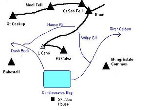
To the south of Great Calva, at the centre of the Northern Fells, is Skiddaw Forest. Confusingly this Forest contains no trees, —other than the windbreak of Skiddaw House — but is a marshy upland area at around 1,300 ft surrounded on all sides by higher fells. Three streams flow from Skiddaw Forest, dividing the Northern Fells into three sectors. Dash Beck runs north west, the River Caldew north east and the River Glenderaterra south. The three groups of fells can conveniently be thought of as the Skiddaw massif, the Blencathra group and Back O'Skiddaw. The single building in Skiddaw Forest is Skiddaw House which has variously seen service as a shepherds' bothy and a Youth Hostel.
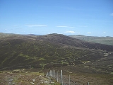
Great Calva appears from Skiddaw Forest as a steep sided pyramid, clad predominantly in heather. The summit is a curving ridge half a mile long, with Great Calva at the eastern end and Little Calva to the west. The ridge itself is extremely wet underfoot. From between the two tops, Dead Beck runs down into Candleseaves Bog, the source of both the Caldew and Dash Beck. Great Calva has a prominent southern spur, around which the Caldew flows before steering north east for the Eden Valley. In a strict topographical sense Candleseaves Bog is the connection between Great Calva and Skiddaw, but it could hardly be described as a ridge route.
Running north east from Little Calva is a ridge which drops to a col
Mountain pass
A mountain pass is a route through a mountain range or over a ridge. If following the lowest possible route, a pass is locally the highest point on that route...
at 1,797 ft, before rising up the flanks of Knott. There are a couple of small tarns
Tarn (lake)
A tarn is a mountain lake or pool, formed in a cirque excavated by a glacier. A moraine may form a natural dam below a tarn. A corrie may be called a cirque.The word is derived from the Old Norse word tjörn meaning pond...
on the Great Calva side of the depression. From the col Wiley Gill runs south east to join the Caldew and Hause Gill flows westward to Dash Beck.
Little Calva sends out a further descending ridge to the north west, running alongside Dash Beck. A series of spurs named Black Nettle Hause, Little Nettle Hause and White Hause drop toward the river. Between Black Nettle Hause and Birkett Edge on Bakestall
Bakestall
Bakestall is a fell in the English Lake District, it is situated seven kilometres north of Keswick in the quieter even secluded northern sector of the national park known as "Back o' Skiddaw".-Topography:...
the beck reaches Whitewater Dash, a fine series of waterfalls.
Summit and view
A cairnCairn
Cairn is a term used mainly in the English-speaking world for a man-made pile of stones. It comes from the or . Cairns are found all over the world in uplands, on moorland, on mountaintops, near waterways and on sea cliffs, and also in barren desert and tundra areas...
stands at the top of the south ridge with another a little to the north at the highest point. The remains of an old fence runs between the two. A few yards east of the summit a stone windshelter has been constructed. There is some rock in evidence but grass and heather predominate.
The view southward, particularly from the lower cairn is unexpectedly good. Looking directly down the Glenderaterra Valley and the Vale of St John, the gap gives an unimpeded view as far as Loughrigg
Loughrigg Fell
Loughrigg Fell is a hill in the central part of the English Lake District. It stands on the end of the long ridge coming down from High Raise over Silver How towards Ambleside, and is separated from its neighbours by the depression of Red Bank....
and Steel Fell
Steel Fell
Steel Fell is a fell in the English Lake District, lying between Thirlmere and Grasmere. It is triangular in plan, the ridges running north, west and south east...
. Additionally above the flanks of Lonscale Fell
Lonscale Fell
Lonscale Fell is a hill in the English Lake District. Its pointed second top is instantly recognisable, standing at the eastern end of the Skiddaw massif. The fell is easily climbed from Keswick or from Skiddaw House to the north...
Great Gable
Great Gable
Great Gable is a mountain lying at the very heart of the English Lake District, appearing as a pyramid from Wasdale , but as a dome from most other directions. It is one of the most popular of the Lakeland fells, and there are many different routes to the summit...
and the Scafells
Scafells
Image:Annotated Scafell range.jpg|thumb|right|300px|The Scafell range as seen looking west from Crinkle Crags. rect 23 372 252 419 Slight Side rect 173 794 560 834 Scafell East Buttress...
appear. The nearer fells by contrast turn their backs upon Great Calva, the northward vista being less inspiring.
Ascents
Great Calva is mainly covered in heather, which makes walking relatively difficult. From the north west an approach can be made from Orthwaite, following a bridleway between Great CockupGreat Cockup
Great Cockup is a fell in the northern region of the English Lake District, one of the four Uldale Fells .- Description :...
and Little Calva to the col between Knott and the summit. Alternatively Great Calva can be climbed up the pathless south ridge from Skiddaw Forest, which creates a number of options for starting points. The Skiddaw House supply road follows Dash Beck up from Peter House Farm, or a good track runs alongside the Caldew from the road at Mosedale. Access is also possible up the Glenderaterra valley from the south, starting either from the Gale Road car park or the vicinity of Threlkeld
Threlkeld
Threlkeld is a village and civil parish in the north of the Lake District in Cumbria, England, to the east of Keswick. It lies at the southern foot of Blencathra, one of the more prominent fells in the northern Lake District, and to the north of the River Glenderamackin.Historically a part of...
.