
Gragareth
Encyclopedia
Gragareth is a mountain in Lancashire
, England
. At 627 metres (2,057 ft) it is claimed to be the highest point in Lancashire, although Green Hill
(628 metres (2,060 ft)), 2 km north and on the Lancashire-Cumbria
border, takes this title in List of English counties by highest point. The summit
of Gragareth lies about 200m west of the boundary between Lancashire and North Yorkshire
, and thus lies just outside the Yorkshire Dales National Park
(whose boundary follows the county boundary at this point). The south eastern slopes are known as Leck Fell
and the southern slopes form Ireby Fell.
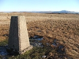
 The summit has a trig point
and extensive views towards Morecambe Bay
, the Lake District
fells, the Howgill Fells
, Ingleborough
, and the Forest of Bowland
. The county boundary wall running along the ridge is believed to be "one of the highest dry stone walls in the country." Historically it formed the boundary between Yorkshire and Westmorland
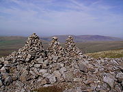
. The Three Men of Gragareth are a group of tall cairns on the western side of the hill above Leck Fell House.
The fell contains several caves including Lost John's Cave
, Rumbling Hole
and Ireby Fell Cavern
.
Wainwright
includes "The ascent of Gragareth via Leck Fell returning via Ireby Fell" in his Walks in Limestone Country. His route begins at Ireby
village, following a lane from Todgill farm on the Leck
road to the tarmac road which leads to Leck Fell House, then "a steep scramble" up past the Three Men. His descent route is down a long enclosure formed by the county boundary to the east and the almost-parallel boundary between Leck and Ireby parishes, dropping down Ireby Fell past the opening of Ireby Fell Cavern, to return to Ireby.
Lancashire
Lancashire is a non-metropolitan county of historic origin in the North West of England. It takes its name from the city of Lancaster, and is sometimes known as the County of Lancaster. Although Lancaster is still considered to be the county town, Lancashire County Council is based in Preston...
, England
England
England is a country that is part of the United Kingdom. It shares land borders with Scotland to the north and Wales to the west; the Irish Sea is to the north west, the Celtic Sea to the south west, with the North Sea to the east and the English Channel to the south separating it from continental...
. At 627 metres (2,057 ft) it is claimed to be the highest point in Lancashire, although Green Hill
Green Hill (Lancashire)
Green Hill is a mountain in north west England. Its summit is above sea level. It is located above Cowan Bridge, Lancashire, between Kirkby Lonsdale, Cumbria and Ingleton, North Yorkshire...
(628 metres (2,060 ft)), 2 km north and on the Lancashire-Cumbria
Cumbria
Cumbria , is a non-metropolitan county in North West England. The county and Cumbria County Council, its local authority, came into existence in 1974 after the passage of the Local Government Act 1972. Cumbria's largest settlement and county town is Carlisle. It consists of six districts, and in...
border, takes this title in List of English counties by highest point. The summit
Summit (topography)
In topography, a summit is a point on a surface that is higher in elevation than all points immediately adjacent to it. Mathematically, a summit is a local maximum in elevation...
of Gragareth lies about 200m west of the boundary between Lancashire and North Yorkshire
North Yorkshire
North Yorkshire is a non-metropolitan or shire county located in the Yorkshire and the Humber region of England, and a ceremonial county primarily in that region but partly in North East England. Created in 1974 by the Local Government Act 1972 it covers an area of , making it the largest...
, and thus lies just outside the Yorkshire Dales National Park
Yorkshire Dales
The Yorkshire Dales is the name given to an upland area in Northern England.The area lies within the historic county boundaries of Yorkshire, though it spans the ceremonial counties of North Yorkshire, West Yorkshire and Cumbria...
(whose boundary follows the county boundary at this point). The south eastern slopes are known as Leck Fell
Leck Fell
Leck Fell is a Site of Special Scientific Interest in Lancashire. An area of typically heavily grazed open moorland of rough grass and remnant patches of heather with little or no tree cover, it is characterised by the virtual absence of surface drainage and an extensive subterranean drainage...
and the southern slopes form Ireby Fell.
Trig point
A triangulation station, also known as a triangulation pillar, trigonometrical station, trigonometrical point, trig station, trig beacon or trig point, and sometimes informally as a trig, is a fixed surveying station, used in geodetic surveying and other surveying projects in its vicinity...
and extensive views towards Morecambe Bay
Morecambe Bay
Morecambe Bay is a large bay in northwest England, nearly due east of the Isle of Man and just to the south of the Lake District National Park. It is the largest expanse of intertidal mudflats and sand in the United Kingdom, covering a total area of 310 km².-Natural features:The rivers Leven,...
, the Lake District
Lake District
The Lake District, also commonly known as The Lakes or Lakeland, is a mountainous region in North West England. A popular holiday destination, it is famous not only for its lakes and its mountains but also for its associations with the early 19th century poetry and writings of William Wordsworth...
fells, the Howgill Fells
Howgill Fells
The Howgill Fells are hills in Northern England between the Lake District and the Yorkshire Dales, lying roughly in between the vertices of a triangle made by the towns of Sedbergh, Kirkby Stephen and Tebay....
, Ingleborough
Ingleborough
Ingleborough is the second highest mountain in the Yorkshire Dales. It is one of the Yorkshire Three Peaks, the other two being Whernside and Pen-y-ghent. Ingleborough is frequently climbed as part of the Yorkshire Three Peaks Challenge, which is a 24-mile circular challenge walk starting and...
, and the Forest of Bowland
Forest of Bowland
The Forest of Bowland, also known as the Bowland Fells, is an area of barren gritstone fells, deep valleys and peat moorland, mostly in north-east Lancashire, England. A small part lies in North Yorkshire, and much of the area was historically part of the West Riding of Yorkshire...
. The county boundary wall running along the ridge is believed to be "one of the highest dry stone walls in the country." Historically it formed the boundary between Yorkshire and Westmorland
Westmorland
Westmorland is an area of North West England and one of the 39 historic counties of England. It formed an administrative county from 1889 to 1974, after which the entirety of the county was absorbed into the new county of Cumbria.-Early history:...
. The Three Men of Gragareth are a group of tall cairns on the western side of the hill above Leck Fell House.
The fell contains several caves including Lost John's Cave
Lost John's Cave
Lost John's Cave is the most extensive cave system on Leck Fell, North Yorkshire, England. With its three major vertical routes it is a popular place to practice SRT because of the opportunity for exchange trips...
, Rumbling Hole
Rumbling Hole
Rumbling Hole is one of the many fenced off sink holes near the road on Leck Fell, North Yorkshire, England. The entrance shaft is approximately 50m deep and often with a small waterfall cascading down the side opposite the single solitary Yew tree that grows at the edge of the vertical shaft and...
and Ireby Fell Cavern
Ireby Fell Cavern
Ireby Fell Cavern is a cave system on Leck Fell, North Yorkshire, England.This popular cave starts with a pitch series that eventually opens out into a very large series of dry sandy passages....
.
Wainwright
Alfred Wainwright
Alfred Wainwright MBE was a British fellwalker, guidebook author and illustrator. His seven-volume Pictorial Guide to the Lakeland Fells, published between 1955 and 1966 and consisting entirely of reproductions of his manuscript, has become the standard reference work to 214 of the fells of the...
includes "The ascent of Gragareth via Leck Fell returning via Ireby Fell" in his Walks in Limestone Country. His route begins at Ireby
Ireby, Lancashire
Ireby is a small hamlet and civil parish on the edge of Lancashire, England, bordering North Yorkshire. It lies in the City of Lancaster, just outside the Yorkshire Dales, near the community of Masongill. The parish had a population of 78 according to the 2001 Census. The name means "Town of the...
village, following a lane from Todgill farm on the Leck
Leck, Lancashire
Leck is a civil parish in the English county of Lancashire. The parish of Leck had a population of 189 recorded in the 2001 census, It is on the River Leck close to the main A65, south east of the Cumbrian town of Kirkby Lonsdale...
road to the tarmac road which leads to Leck Fell House, then "a steep scramble" up past the Three Men. His descent route is down a long enclosure formed by the county boundary to the east and the almost-parallel boundary between Leck and Ireby parishes, dropping down Ireby Fell past the opening of Ireby Fell Cavern, to return to Ireby.