

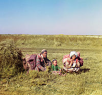
Golodnaya Steppe
Encyclopedia
Loess
Loess is an aeolian sediment formed by the accumulation of wind-blown silt, typically in the 20–50 micrometre size range, twenty percent or less clay and the balance equal parts sand and silt that are loosely cemented by calcium carbonate...
plain of some 10,000 km2 on the left bank of Syr Darya
Syr Darya
The Syr Darya , also transliterated Syrdarya or Sirdaryo, is a river in Central Asia, sometimes known as the Jaxartes or Yaxartes from its Ancient Greek name . The Greek name is derived from Old Persian, Yakhsha Arta , a reference to the color of the river's water...
in Uzbekistan
Uzbekistan
Uzbekistan , officially the Republic of Uzbekistan is a doubly landlocked country in Central Asia and one of the six independent Turkic states. It shares borders with Kazakhstan to the west and to the north, Kyrgyzstan and Tajikistan to the east, and Afghanistan and Turkmenistan to the south....
, extending from the mouth of Ferghana Valley on the border with Tajikistan
Tajikistan
Tajikistan , officially the Republic of Tajikistan , is a mountainous landlocked country in Central Asia. Afghanistan borders it to the south, Uzbekistan to the west, Kyrgyzstan to the north, and China to the east....
to the east across Syrdarya Province and the northern part of Jizzakh Province
Jizzakh Province
Jizzakh Province is a viloyat of Uzbekistan located in the center of the country. It borders with Tajikstan to the south and south-east, Samarqand Province to the west, Navoiy Province to the north-west, Kazakhstan to the north, and Sirdaryo Province to the east. It covers an area of 20,500 km²...
to the west. To the south it is bounded by Turkestan Range
Turkestan Range
One of the westernmost extensions of the massive Tian Shan system, the Turkestan Range stretches for a total length of 340 km from the Alay Mountains on the border of Kyrgyzstan with Tajikistan to the Samarkand oasis in Uzbekistan...
. Geographically Golodnaya Steppe is a south-eastern extension of the Kyzyl Kum
Kyzyl Kum
The Kyzyl Kum , also called Qyzylqum, is the 11th largest desert in the world. Its name means Red Sand in Turkic languages. It is located in Central Asia in the doab between the rivers Amu Darya and Syr Darya, and is divided between Kazakhstan, Uzbekistan and Turkmenistan...
desert, with about 240 mm of annual precipitation and extreme continental climate (average temperatures from 28°C in July to −2°C in January). Efforts that began as early as the end of the 19th century gradually transformed the Golodnaya Steppe from a desert into an intensively irrigated agricultural area, today one of the major cotton and grain producing regions of Uzbekistan with around 500,000 hectares of irrigated land under cultivation. Three main canals constructed in the 1950s and the 1960s bring water to Golodnaya Steppe farms. These are the north-south Central and Northern Canals and the east-west South Golodnaya Steppe Canal. Guliston
Guliston
Guliston also spelled as Gulistan , formerly known as Mirzachul , is the capital of Sirdarya Province in eastern Uzbekistan. It lies in the southeastern part of the Mirzachül steppe, 75 miles southwest of Tashkent. It has an approx. population of 77,300...
and Yangier
Yangier
Yangiyer is a city in Sirdaryo Province, Eastern Uzbekistan. It was established in 1957 as part of the grand Soviet project to cultivate the naturally saline virgin lands of Golodnaya Steppe, a vast area of about 10,000 square kilometres in Eastern Uzbekistan...
, both in Syrdarya Province, are the main population centers in Golodnaya Steppe.