

Gojal
Encyclopedia
Gilgit
Gilgit is a city in northern PakistanGilgit may refer to other terms related with the area of the city:* Gilgit River* Gilgit Valley* Gilgit District* Gilgit Agency * Gilgit Airport...
in the far north of Pakistan
Pakistan
Pakistan , officially the Islamic Republic of Pakistan is a sovereign state in South Asia. It has a coastline along the Arabian Sea and the Gulf of Oman in the south and is bordered by Afghanistan and Iran in the west, India in the east and China in the far northeast. In the north, Tajikistan...
near the Chinese
China
Chinese civilization may refer to:* China for more general discussion of the country.* Chinese culture* Greater China, the transnational community of ethnic Chinese.* History of China* Sinosphere, the area historically affected by Chinese culture...
and Afghan
Afghanistan
Afghanistan , officially the Islamic Republic of Afghanistan, is a landlocked country located in the centre of Asia, forming South Asia, Central Asia and the Middle East. With a population of about 29 million, it has an area of , making it the 42nd most populous and 41st largest nation in the world...
borders. It is the largest tehsil
Tehsil
A Tehsil or Tahsil/Tahasil , also known as Taluk and Mandal, is an administrative division of some country/countries of South Asia....
of the Gilgit-Baltistan autonomous area of northern Pakistan.
Gojal is a series of small and large valleys sharing borders with Hunza
Hunza (princely state)
Hunza was a princely state in the northernmost part of the Northern Areas of Pakistan until 1974. The state was also known as Kanjut. The state bordered the Gilgit Agency to the south, the former princely state of Nagar to the east, China, to the north and Afghanistan to the northwest. The state...
in the south, China in the north and east, and Afghanistan
Afghanistan
Afghanistan , officially the Islamic Republic of Afghanistan, is a landlocked country located in the centre of Asia, forming South Asia, Central Asia and the Middle East. With a population of about 29 million, it has an area of , making it the 42nd most populous and 41st largest nation in the world...
in the north-west. Shishkat is the first village of Gojal. Except for the Shimshal, Misgar and Chipursan valleys, all the villages of Gojal can be seen from the Karakorum Highway (KKH), which crosses Gojal, entering China at the Khunjerab Pass
Khunjerab Pass
Khunjerab Pass is a high mountain pass in the Karakoram Mountains in a strategic position on the northern border of Pakistan's Gilgit-Baltistan region within the disputed region of Kashmir and on the southwest border of the Xinjiang region of China...
.
History
The valleys and villages of Gojal were settled over time by people from surrounding regions. In the opinion of most researchers , Kirghiz nomads initially used the areas in upper Gojal as winter pastures. It is said that later on when Wakhies migrated from WakhanWakhan
Wakhan or "the Wakhan" is a very mountainous and rugged part of the Pamir and Karakoram regions of Afghanistan. Wakhan District is a district in Badakshan Province.-Geography:...
to this region, the Kirghiz nomads left. It is very difficult to determine when the Wakhies settled in Gojal. However, it is narrated that the earlier Wakhi migrated from Wakhan and settled in the Yishkuk (Chipursun) valley and later the Boiber areas. It is also narrated that when Hunza
Hunza (princely state)
Hunza was a princely state in the northernmost part of the Northern Areas of Pakistan until 1974. The state was also known as Kanjut. The state bordered the Gilgit Agency to the south, the former princely state of Nagar to the east, China, to the north and Afghanistan to the northwest. The state...
was under the Central Government of Gilgit
Gilgit
Gilgit is a city in northern PakistanGilgit may refer to other terms related with the area of the city:* Gilgit River* Gilgit Valley* Gilgit District* Gilgit Agency * Gilgit Airport...
the Ishkook settlement was wealthy and paid cattle and other dairy product
Dairy product
Dairy products are generally defined as foods produced from cow's or domestic buffalo's milk. They are usually high-energy-yielding food products. A production plant for such processing is called a dairy or a dairy factory. Raw milk for processing comes mainly from cows, and, to a lesser extent,...
s to the Raja of Gilgit. As Hunza emerged as an independent state
Sovereign state
A sovereign state, or simply, state, is a state with a defined territory on which it exercises internal and external sovereignty, a permanent population, a government, and the capacity to enter into relations with other sovereign states. It is also normally understood to be a state which is neither...
during the early 15th century so it can be inferred that different valleys in upper Gojal were inhabited by the Wakhi speaking migrants prior to the emergence of the Hunza state
Hunza (princely state)
Hunza was a princely state in the northernmost part of the Northern Areas of Pakistan until 1974. The state was also known as Kanjut. The state bordered the Gilgit Agency to the south, the former princely state of Nagar to the east, China, to the north and Afghanistan to the northwest. The state...
. Later, the oral history
Oral history
Oral history is the collection and study of historical information about individuals, families, important events, or everyday life using audiotapes, videotapes, or transcriptions of planned interviews...
holds, a catastrophic flood destroyed the Ishkook settlement during the 18th century.
Settlement of Gulkin
There is no accurate historical record of the origin of the village, though it is estimated to be around 600 years old. According to local folklore, there were settlements here while the lake was still in existence, this area being used as pastureland in summer. The name is derived from two words of the local WakhiWakhi
Wakhi may be:* The Wakhi language, the language of the majority of the people of Wakhan* Wakhi, an ethnic group in Wakhan, Afghanistan* An adjective; of or relating to Wakhan, the extreme northeastern region of Afghanistan that borders China, Tajikistan, and Pakistan...
dialect, 'Ghulk', meaning 'well' and 'kin', meaning 'whose'. Being an area of low rainfall, the most vital requirement is water for irrigation, livestock, drinking and domestic use. Khawaja Ahmed, and Ismaili Muslim who came here with the Mir of Hunza
Mir of Hunza
The Mir of Hunza was the title of the rulers of the Hunza Valley in the Northern Areas, Pakistan.The Mir used to have the Burushaski title of Tham, later changed to Mir. In 1974 the state became a part of the Northern Areas of Pakistan under the Pakistani Federal Government...
, asked him for land. After the Mir agreed, Khawaja Ahmed mobilised the people of the area to construct a water-channel to irrigate the land. This made cultivation possible and the Ismaili settlement flourished. Now small scale health and educational institutions, electricity and water-sully facilities are available in the village. Through the involvement of capacity-building NGOs, there is also a handicraft production centre and opportunities for other vocational training.
The Jammatkhana, the central religious institution for all Ismaili Muslims, holds a strong position in the community. Apart from its religious functions, it provides a central location for community meetings, festivals, celebrations, resolution of disputes and other community activity. In Upper Hunza, winters are long and can become bitterly cold. Snowfall brings with it the Himalayan ibex, descending in search of grass under the snow cover. Summers are hot in the north, though more pleasant than the harsh temperatures in summer are around 30 degrees Celsius. In winter the temperature remains below freezing point, further dropping at night
Geography
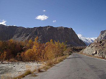
Geographically Gojal is located between 70 latitude and 61 and is spread over an area of 8,500 km² of land, at an elevation ranging from 2,340m to 4,877m, above the sea level.Gojal is a mountainous region forming the western part of the Karakoram and Eastern Pamir mountain range
Mountain range
A mountain range is a single, large mass consisting of a succession of mountains or narrowly spaced mountain ridges, with or without peaks, closely related in position, direction, formation, and age; a component part of a mountain system or of a mountain chain...
. This area also hosts the 56 km long Batura glacier
Batura Glacier
Batura Glacier is one of the largest and longest glaciers outside the polar regions. It lies in the Gojal region of the Northern Areas of Pakistan, just north of Batura and Passu massifs. It flows west to east...
the fourth longest of Pakistan (after Siachin, Hispar and Biafo).
The region is home to lofty ice capped peaks, roaring rivers, lush green pastures and long glaciers.
Villages
The main villages of this district include: Shishket (now Nazeemabad), GulmitGulmit
Gulmit is the headquarter of the Gojal Tehsil, in the upper Hunza region of the Gilgit territory in the deep in the Karakoram Mountain Range. Gulmit is a centuries-old historic town, with mountains, peaks and glaciers. It is a tourist spot and has many hotels, shops and a museum...
, Ghulkin, Husseini
Husseini
Husseini is an Arabic surname.-Etymology:It is a nisba derivation of the given name Hussein...
(older names Sisoni/Ghusani), Borith, Passu
Passu
Passu is a small village on the Karakoram Highway, beside the Hunza River, some 15 kilometers from Gulmit, the Tehsil Headquarter of Gojal in the Gilgit-Baltistan region of Pakistan, and about 150 km upriver from Gilgit. It lies very near the tongue of the Pasu Glacier, and just south of the...
, Shimshal
Shimshal
Shimshal شمشال is a beautiful village located in Gojal, Hunza-Nagar District, in the Pakistan-administered Gilgit-Baltistan formerly known as Northern Areas of Pakistan. It lies at an altitude of 3,200 m above sea level, and is the highest settlement in Hunza Valley of Pakistan...
, Khyber
Khyber
The term Khyber may refer to:*The Khyber Pakhtunkhwa, a province of Pakistan*The Khyber Pass, a mountain pass that links Pakistan and Afghanistan.*The Khyber Agency, part of the Federally Administered Tribal Areas of Pakistan....
, Ghalapan, Morkhoon, Jamalabad
Jamalabad
Jamalabad fort, located 8 km north of Beltangadi town, is 1788 ft above sea level and was formerly called Narasimha Ghada, which refers to the granite hill on which the fort is built. It is also referred locally as 'Jamalagadda' or 'Gadaikallu'.The fort was built by Tippu Sultan in 1794 and named...
, Gircha, Sartiz, Sost
SOST
Sclerostin is a protein that in humans is encoded by the SOST gene.-External links:*-Further reading:...
, Khudaabad, Misgar, Yarzerech, Raminj, Kirmin, Reshit Khill, Shersabz, Ispenj, Shitmerg and Zoodkhoon.
Administration
GulmitGulmit
Gulmit is the headquarter of the Gojal Tehsil, in the upper Hunza region of the Gilgit territory in the deep in the Karakoram Mountain Range. Gulmit is a centuries-old historic town, with mountains, peaks and glaciers. It is a tourist spot and has many hotels, shops and a museum...
, the winter-capital of the then Hunza state until 1974, is the main town (Tehsil Head Quarters) and seat of government, while Sost
SOST
Sclerostin is a protein that in humans is encoded by the SOST gene.-External links:*-Further reading:...
is the border check-post and gateway for Pakistan
Pakistan
Pakistan , officially the Islamic Republic of Pakistan is a sovereign state in South Asia. It has a coastline along the Arabian Sea and the Gulf of Oman in the south and is bordered by Afghanistan and Iran in the west, India in the east and China in the far northeast. In the north, Tajikistan...
-China overland trade. The entire region is governed by Pakistani bureaucrats, sitting in Gilgit
Gilgit
Gilgit is a city in northern PakistanGilgit may refer to other terms related with the area of the city:* Gilgit River* Gilgit Valley* Gilgit District* Gilgit Agency * Gilgit Airport...
. Law and order is supported by two police station
Police station
A police station or station house is a building which serves to accommodate police officers and other members of staff. These buildings often contain offices and accommodation for personnel and vehicles, along with locker rooms, temporary holding cells and interview/interrogation rooms.- Facilities...
s and a magistrate
Magistrate
A magistrate is an officer of the state; in modern usage the term usually refers to a judge or prosecutor. This was not always the case; in ancient Rome, a magistratus was one of the highest government officers and possessed both judicial and executive powers. Today, in common law systems, a...
.
Tourist Sites
Passu ValleyPassu is known for the Batura Glacier and Passu Glacier, and Mount Tupopdon at the north end of the villages. Inspired by its unique structural attributes, tourists have promoted the peak by giving it new names. Some call it "Passu Cones" and others "Passu Cathedral". Mount Tupopdon is the most photographed peak of the region.
With its diverse places, people and customs, Passu is the mixing bowl of ancient civilization and dream of nature lovers, is well known for its contrasting landscapes of the world. From times, immemorial, the village has served as a mountainous resort, situated in the spectacular Karakoram Mountains on the old silk route 150 km from Gilgit in the west banks of Hunza River and border on China. Many adventurers, eco-tourists, historians and nature lovers visit the area.
Passu is a high mountainous region, with nothing below 2,500 metres; specific mountain peaks include Passu (7284 metres), Shisper (7611 metres), Batura (7785 metres), and the most remarkable is Passu cathedral peak at 6500 metres.
Shimshal Valley ŠIMŠAL DIYOR
Shimshal's inaccessibility does not stop tourists from visiting the area as there is a great deal of natural beauty.
Chipursan Valley
Chipursan valley is a network of small and large villages close to the border of Afghanistan and parts of China. Historians say that this was the earliest human settlement
Colonisation
Colonization occurs whenever any one or more species populate an area. The term, which is derived from the Latin colere, "to inhabit, cultivate, frequent, practice, tend, guard, respect", originally related to humans. However, 19th century biogeographers dominated the term to describe the...
of the entire region. Chipursan is home to the Irshad Pass that connects Gojal Valley with Afghanistan. Also located in the vicinity of Chipursan Valley are Ishkoman, Buroghil and Yasin valleys.
Misgar Valley
Misgar valley is a narrow human settlement located very close to the Chinese border, almost parallel to Chipursan. Misgar is home to the Qalamdarchi Fort Fort of the Naked Saint. This "fort" was created by the British rulers of Hunza Valley to keep an eye on the movement of Soviet troops and spies in the region. Kilik and Mintika Passes were used by traders, troops, travellers and spies in the past. This fort is in a dilapidated condition. Parts of the fort are being used by Jawans of Pakistan Army
Pakistan Army
The Pakistan Army is the branch of the Pakistani Armed Forces responsible for land-based military operations. The Pakistan Army came into existence after the Partition of India and the resulting independence of Pakistan in 1947. It is currently headed by General Ashfaq Parvez Kayani. The Pakistan...
.
External links
- Blankonthemap The Northern Kashmir WebSite
- PAMIR TIMES
- GOJAL NET
- Ghulkin Village
- Gojal Photo Gallery
- Gojal Eco Tourism Study
- http://www.passu.webs.com
- http://www.gulbaturpassu.com
Pakistan°N date=December 2010°W